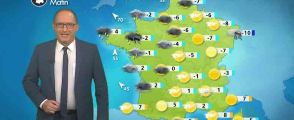
To remember
– degradation in the north rainy in the north, especially in Brittany
– black ice possible before the evening thaw in the northeast
– strong winds in Brittany as well as from Midi-Toulousain to Languedoc
– very severe frosts in the morningdown to -15°C in the plain in the northeast on snowy ground
Evolution compared to yesterday
This Sunday marks the beginning of a radical change in weather with the lifting of the southerly wind linked to the approach of an Atlantic depression. This is accompanied by a deterioration in the north with the return of rain and wind, preceded by a little snow and ice. In the south, the sun is less valiant than on Saturday with a sky that becomes increasingly cloudy in the afternoon and the return of maritime entries into Languedoc-Roussillon and the Cévennes.
Details by region
To the northwest, the change in weather is radical with rain preceded by a bit of ice this morning before the thaw in the afternoon. The South wind rises and blows at 90 km / h in gusts in the evening on Finistère where the rains are very abundant.
Min: from -5 to 5°C / Max: from 2°C in Rouen to 11°C in Brest where the thaw will be marked
On the Paris basinafter a freezing night, the sky quickly covered and a little rain fell from the middle of the afternoon.
Min: from -8 to 0°C / Max: 0°C in Seine-et-Marne to 5°C in Yvelines, the thaw will be quick in the evening
To North-east, like the previous mornings, very strong frosts occur at daybreak. On the sky side, it veils in the afternoon in the Grand-Est where the weather remains dry and becomes cloudy in the Hauts-de-France and the Ardennes where a little icy weather precedes the mild spell of the night from Sunday to Monday. Be careful in these regions at the risk of ice tonight.
Min: from -15 to -5°C / Max: around 0°C, the thaw is expected overnight from Sunday to Monday
At the South West, after the dissipation of the fogs, you spend the day in the dry under a sky which veils more and more frankly as the hours go by. The South wind rises over the Pyrenees and the Autan at 80 km/h north of Toulouse towards the Tarn.
Min: from -3 to 2°C / Max: from 7 to 15°C in the Basque country
In the Center East, It’s very cold this morning under a sky that is getting heavy over the south of Rhône-Alpes with showers in the afternoon in Ardèche and a southerly wind that reaches 70 km / h in Haute-Loire and Loire in the evening . In the Alps, you enjoy a superb day of skiing, after a freezing night.
Min: from -10 to -20°C in the mountains to -3°C south of Lyon / Max: from 3 to 7°C with a thaw that sets in in the evening
Near the Mediterranean, it is degradation. The marine wind rises and strengthens to 70 km / h in gusts in the evening. It transports the clouds from the Mediterranean to Languedoc-Roussillon to Provence with a few showers. From Provence Côte d’Azur to Corsica, after the morning sun, the sky is veiled.
Min: from -3°C in the hinterland to 5°C in the Roussillon plain in the morning / between 9 and 11°C in the afternoon, with peaks of 15°C in Bastia and Nice.
Subsequent trend : tomorrow Monday, the disturbance of Sunday will go up towards the English Channel with an improvement in the north of the Loire. In the south, the weather will be quite fine, except for the Cévennes on the shores of the Mediterranean where there will be some showers in the mountains.

