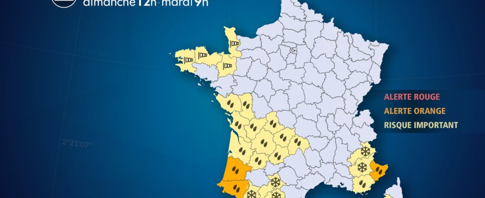
From Sunday February 25 at 12:00 to Tuesday February 27 at 9:00.
Complete live weather forecasts by telephone at
3201*
Situation
A vast system of low pressure encompasses all of western Europe and is causing lastingly disturbed weather in France. A depression plunges from the English Channel towards the Mediterranean between Sunday and Tuesday. It brings heavy rains in the southwest and southeast as well as a gale along the Channel. Due to this ongoing or expected heavy rainfall, there is a risk of runoff and flooding. In the mountains, in the Pyrenees and the southern Alps, heavy snowfall occurs with blizzard conditions at altitude.
Observation
This Sunday
At 6 p.m., the rains continued in the southwest where the accumulations increased quickly. Between Saturday and Sunday 5 p.m., they reach 65 mm in Gujan-Mestras (33), 50 mm at Cap Ferret (33), 42 mm in Bordeaux (33) and 30 mm in Laruns (64), which corresponds to 2 weeks of precipitation. In the Alpes-Maritimes, the rains are intensifying rapidly: on Sunday, between 4 and 6 p.m., 21 mm of water has already fallen in Fréjus (83) and 10 mm in Mandelieu (06).
At 15h, The rains continue in the southwest, bringing significant quantities of water since this morning with an average of 10 to 20 mm in the departments placed on alert by our services. The sky is getting busy in Provence Côte d’Azur and Corsica.
At 12, the Atlantic disturbance continues to cause a lot of rain in the southwest. Over the last 12 hours, 30 mm fell in Cazaux (33), 25 mm in Biarritz (64), 20 mm in Plouay (56) and 15 mm in Dax (40). Since Thursday, accumulations have already reached 100 mm in Dax and Biarritz, corresponding to 1 month of precipitation.
At 9 a.m., New Aquitaine is subject to rain, sometimes heavy storms, from Gironde to the Pyrénées-Atlantiques. Since Friday morning, 75 mm of water has fallen in Biarritz (64), 72 mm in Bidache (64), 50 mm in Dax (40) and Captieux (33), which corresponds to 2 to 3 weeks of rain.
Evolution
Tonight
As the Irish depression approaches, precipitation continues, increasing the risk of river reactions in the south-west regions with waterlogged soils on alert. At the same time, an episode of bad weather is setting in in the south-east of France this evening, with Provence Alpes Côte d’Azur and Corsica being particularly targeted. The wind picks up near the English Channel, reaching 90 km/h at dawn Monday.
Monday
The episode of heavy precipitation continues in PACA and Corsica, bringing significant amounts of rain along the seaside and intense snowfall in the south of the Alps, from Mercantour to Queyras. In the southwest, heavy rain or thunderstorms are circulating from the Aquitaine basin to the Pyrenees, which increases the risk of floods and floods. In the mountains, blizzard conditions persist all day in the Pyrenees from 1200 meters. Near the English Channel, the north wind blows strongly at nearly 100 km/h, with a risk of submersion at high tide due to fairly high tidal coefficients (86).
Tuesday
Bad weather persists in PACA, Corsica and near the Pyrenees with continued heavy rain and thunderstorms as well as heavy snowfall in the mountains. From the afternoon onwards, precipitation begins to weaken, except in Corsica.
Afterwards, Wednesday, if the weather remains very turbulent in Corsica, the improvement continues near the Pyrenees and the south of the Alps in PACA despite some occasional heavy showers in the morning. In the mountains, be careful in the south of the Alps and the Pyrenees with an avalanche risk which could become maximum.
Until Tuesday, we wait
– 50 to 100 mm, locally 150 to 200 mm in the Landes and Pyrénées-Atlantiques, i.e. 3 weeks to 1 and a half months of rain
– 50 to 100 mm of water in Provence Côte d’Azur, locally 150 mm in the interior of the Alpes-Maritimes, between Sunday evening and Tuesday, i.e. 3 weeks to 1 and a half months of rain
– 50 cm to 1.50 m of snow in the mountains around 2000 m in the Pyrenees and the south of the Alps with an avalanche risk which could become maximum on Tuesday
– a gale in the Channel on Monday with gusts to 100 km/h and a risk of submersion at high tide due to fairly high tide coefficients (85 and 86)
List of departments concerned
- 04 – Alpes de Haute Provence
Snow – Significant Risk
- 05 – High mountains
Snow – Significant Risk
- 06 – Alpes-Maritimes
Precipitation – Orange Alert
- 09 – Ariège
Snow – Significant Risk
- 15 – Cantal
Precipitation – Significant Risk
- 16 – Charente
Precipitation – Significant Risk
- 17 – Charente Maritime
Precipitation – Significant Risk
- 19 – Corrèze
Precipitation – Significant Risk
- 2A – South Corsica
Precipitation – Significant Risk
- 22 – Côtes-d’Armor
Wind – Significant Risk
- 24 – Dordogne
Precipitation – Significant Risk
- 29 – Finistère
Wind – Significant Risk
- 31 – Haute-Garonne
Snow – Significant Risk
- 33 – Gironde
Precipitation – Significant Risk
- 35 – Ille-et-Vilaine
Wind – Significant Risk
- 40 – Landes
Precipitation – Orange Alert
- 46 – Batch
Precipitation – Significant Risk
- 47 – Lot-et-Garonne
Precipitation – Significant Risk
- 50 – Sleeve
Wind – Significant Risk
- 64 – Pyrénées-Atlantiques
Precipitation – Orange Alert
- 65 – Hautes-Pyrénées
Snow – Significant Risk
- 79 – Two Sevres
Precipitation – Significant Risk
- 83 -Var
Precipitation – Significant Risk
- 85 – Vendee
Precipitation – Significant Risk
- 87 – Haute-Vienne
Precipitation – Significant Risk