By Briac Trebert
Published on
updated on 21 Nov 22 at 16:23
As expected from last weekenda new Gale is announced for this beginning of the week. And rain. A lot of rain.
From this Monday, November 21, 2022 and Tuesday, November 22, 2022, the entire western part of France and Corsica will be swept away by very strong gusts. For Corsica, it will be a storm, “Storm Denise” named by Aemet, the Spanish weather agency. It should be formed this Monday evening:
3 departments in orange vigilance, 30 others in yellow vigilance
Disturbances generating a lot of rain and a lot of wind are on the menu for the next few hours.
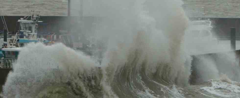
This Monday, November 21 at midday, gusts of wind at more than 110 km / h have already been noted at the tip of Brittany: 120 km / h at Brignogan (Finistère) or 117 km / h at the tip du Raz (Finistère). And it’s not over.
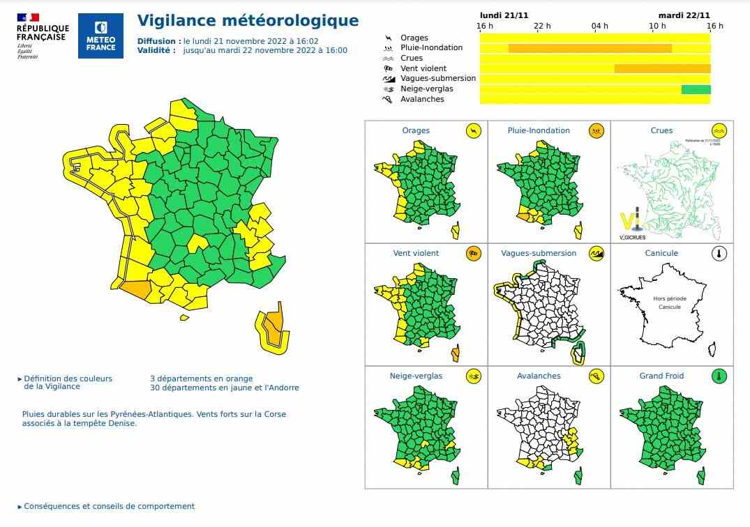
Météo France placed this Monday, November 21, 2022, at 4 p.m., two departments in orange vigilance (Haute-Corse and Corse-du-Sud) and 21 othersmainly on the western side of France in yellow “violent wind” vigilance: Pas-de-Calais, Somme, Seine-Maritime, Eure, Calvados, Manche, Mayenne, Ille-et-VilaineCôtes-d’Armor, Finistère, Morbihan, Loire-Atlantique, Maine-et-Loire, Deux-Sèvres, Vendée, Charente-Maritime, the GirondeThe Landes, Pyrenees-Atlantiquesas well as Aude and Pyrénées-Orientales.
Coasts in yellow vigilance “submergence waves”
And the west coast of France (Seine-Maritime, Côtes-d’Armor, Ille-et-Vilaine, Manche, Finistère, Morbihan, Loire-Atlantique, Vendée, Charente-Maritime, Gironde, Landes, Pyrénées-Atlantiques) is also placed in yellow vigilance “submersion waves” as well as Corse-du-Sud.
“The wind will strengthen this Monday on the entire western facade of France with possible gusts between 110 to 120 km / h on the northwest quarter and more particularly on the coast”, estimates on news.fr meteorologist Yann Amice.
Between Monday and Tuesday, the gusts will also become general in the southwest and in Corsica, where, on the western facade of the island of beauty, gusts of more than 130 km / h are possible.
11 departments on rain-flood vigilance
The reason for this bad weather: two depressions, hollow, at the start of the week, one located south of the British Isles, the other near Corsica. Two depressions which will also generate a lot of rain in the northwest, the southwest and in Corsica, but especially on the Pyrenees-Atlantiques where nearly 100 mm are expected in 24 hours between Monday and Tuesday, locally more by blocking effect on the Pyrenees.
Météo France has placed the Department of Pyrénées-Atlantiques on orange vigilance for “rain-flooding”. The two departments of Corsica, as well as Landes, Gers, Hautes-Pyrénées, Haute-Garonne, Ariège, Manche, Seine-Maritime, and Pas-de-Calais are on yellow alert for the same reason.
Yellow vigilance for “avalanches”due to heavy snowfall, were also issued for the Alps and the Pyrenees.
“The masses of cold air that reign over the North American continent”
In the background of these new disturbances, “the masses of cold air which reign over the North American continent, a cold coming from the Arctic”, details Météo France. “The powerful high-altitude jet current blowing over the North Atlantic is currently exposing it to the deepening of depressions”, popularizes Yann Amice.
Was this article helpful to you? Know that you can follow Actu in space My News . In one click, after registration, you will find all the news of your favorite cities and brands.