
No matter what time of year – the Black Forest High Road keeps making headlines. In the summer it causes trouble, among other things, because motorcyclists loudly heat up their curves. And in winter it is often parked by skiers and other relaxation seekers. Because there were chaotic scenes on the fourth weekend in Advent, the police even want to block the access roads to the Black Forest High Road in the future if the rush should become too big. The scenario is not new: as early as January 2021, thousands from Stuttgart, Karlsruhe and Mannheim streamed into the supposedly quiet heights of the northern Black Forest to stretch their legs during the lockdown, to go around the circular Mummelsee and to enjoy the view over the Rhine enjoy. France is so close here that the cell phone receives short messages about the tariffs in the neighboring country.
The Black Forest High Road, about 60 kilometers long, officially called the B 500, is one of the oldest holiday routes in the country and probably also one of the most historic. It meanders from Baden-Baden up to the Bühlerhöhe and then leads at a height of 800 to 1000 meters from north to south in the direction of Freudenstadt, past peaks of the northern Black Forest such as Hornisgrinde or Schliffkopf. Those who drive it often venture into the unknown: it may well be that the weather down in the health resort at its 161 meters is foggy and cloudy, while the sun is laughing up above. But it can also be that you start in the most beautiful weather, only to torment yourself 700 meters later through a foggy soup.
Building the road along the main ridge of the northern Black Forest was such an ambitious project that many associate it with the megalomania of National Socialism. “The myth that the Black Forest High Road was a child of the Third Reich continues to this day,” says local history researcher Ernst Kafka, who in 2007 compiled a great deal of detailed knowledge about the road in a book. In fact, the idea is a lot older.
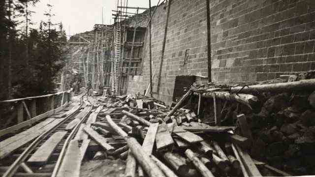
Construction of a retaining wall in the late thirties and early forties.
(Photo: Stadtgeschichtliches Institut Bühl, estate Gottfried Kastl)
While the plateau with its excursion restaurants and ski lifts today mainly attracts day visitors, it has long been a popular destination for long holiday stays: from the end of the 19th century, when luxurious high-altitude hotels were built there, which are mostly empty today, to the time of Federal Chancellor Konrad Adenauer who liked to recover from the rigors of governing on the Bühlerhöhe.
For centuries, the wooded highlands of the northern Black Forest had been an almost impenetrable no man’s land. It was not significantly developed until the 18th century, when the beginning industrialization required more and more wood. While the fuel and building material was initially transported on rivers, in the late 18th and 19th centuries, trafficable roads gradually emerged.
Such logging routes were the forerunners of the elevated road. At the end of the 19th century, guests of the spa town of Baden-Baden made their way to the highlands on them and discovered its charms. Workers’ economies first turned into excursion restaurants and then later high altitude hotels, where summer visitors like to spend several weeks.
A horse-drawn bus drove to the Höhenhotels as early as 1892. Later a motorized bus chugged up the unpaved roads from Baden-Baden. And then more and more “motorists” explored the northern Black Forest – and often got stuck somewhere on poor forest roads.
The Nazis took over the project for themselves
That’s how it started. The designation as a National Socialist project is not unfounded. On the one hand, the Nazi propaganda took over the project, although planning and construction began long before Adolf Hitler came to power in 1933. In July 1933, however, as Kafka reports in his book, a large celebration with swastika flags was staged, after which the route from Baden-Baden to Mummelsee, 31 kilometers long and an average of six meters wide, was opened to traffic.
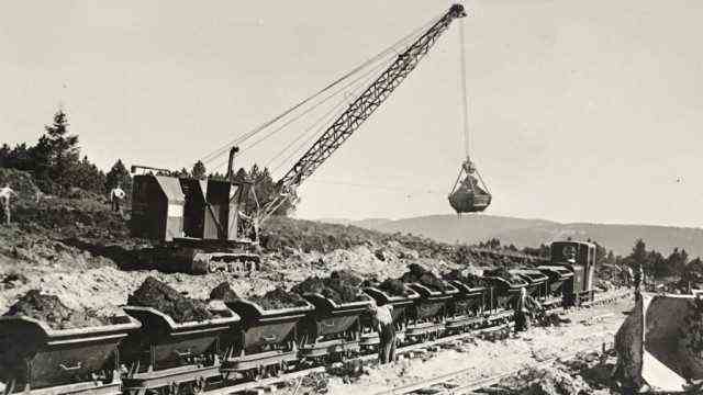
The earthworks were carried out with steam-powered excavators and field railways.
(Photo: Stadtgeschichtliches Institut Bühl, estate Gottfried Kastl)
The extension to the Ruhestein, a mountain pass where the information center of the Northern Black Forest National Park founded five years ago is located, was then pushed forward as part of the so-called job creation programs of the Nazi regime.
The fact that the further course of the Hochstrasse was hammered into the landscape under high pressure in 1939 and 1940 is ultimately entirely due to the Nazi dictatorship.
The northern Black Forest was part of the approximately 50 kilometers wide air defense zone behind the so-called Siegfried Line on the border with France. The military installed guns at strategically favorable points such as the Schliffkopf, and the Kniebis ridge, 15 kilometers away, was chosen as the location for a “Führer Headquarters”.
How strenuous and dangerous the work on the elevated road was in this area was documented by one of those involved with photos that are still impressive today. The photo albums of the builder Georg Kastl are an archival treasure that has been stored in a box in the urban history institute of Bühl for several years and is waiting to be scientifically processed. The grandson had discovered it in the attic and sent it to the small town at the foot of the Black Forest.
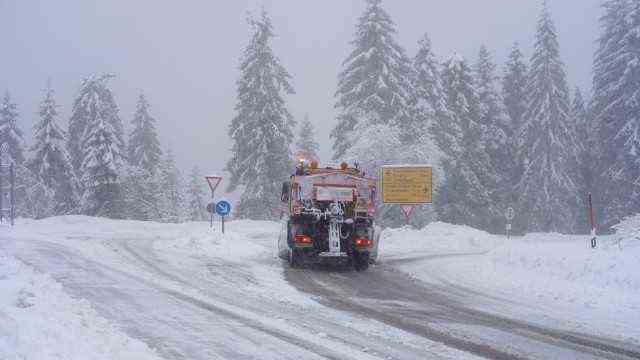
The clearance and gritting services are often used on the road in winter.
(Photo: Benedikt Spether / picture alliance / dpa)
Kastl’s photos show how the workers wrestle a route piece by piece, meter by meter, from the sometimes steep terrain between Ruhestein and Kniebis – first for the locomotive that transported building materials, then for the road itself. They show steam and diesel excavators, formwork and concreting work and workers who collect boulders in order to later split them into red sandstone blocks that were used to cover the retaining walls. It took more than a kilometer and a half of such walls to build the road. Some of Kastl’s additional texts testify to the conditions under which the street was built – even if it is unclear with what time interval and under what political precedent Kastl put his memories on paper.
As a 30-year-old, the builder was initially hired to build camps on the Black Forest heights, which would later house up to 1,300 workers. “350 French prisoners and 350 Yugoslav (sic!) Workers” also lived there for a time, according to the records.
Difficult construction work
According to Kastl’s memories, the work on a 200-meter-long retaining wall, which was erected in steep terrain between the later “Führer Headquarters” and the positions on the Schliffkopf, was particularly arduous – around 500 men were there for weeks on a 400-meter stretch in the autumn of 1940 Mission. “It happened that larger stone avalanches started rolling during blasting and devastated the forest on the steep slope,” noted Kastl. These weren’t the only incidents: “Once, three loaded concrete trucks disconnected, crashed onto the concreting scaffolding, derailed and fell ten meters into the excavation of the wall foundation.” Another time a whole lorry train with two locomotives fell down the slope. “As if by a miracle there were no deaths during the actual construction of the wall. Only when making the road behind the wall was a man crushed while lubricating an excavator.”
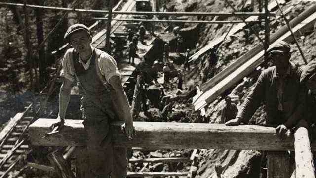
Workers on a concreting scaffold in the construction pit for a retaining wall.
(Photo: Stadtgeschichtliches Institut Bühl, estate Gottfried Kastl)
Overall, from October 1938 to February 1941, Kastl was employed by the Freudenstadt Road and Water Authority for the construction of the Black Forest High Road. He had kept a certified copy of his job reference with the photo albums. The authority was very satisfied.
Hitler was up there only once
The significance of the “Führer Headquarters” is, by the way, controversial. Kafka researched that it consisted of a tea house and a casino, as well as two bunkers for the Wehrmacht command staff, two bathhouses, a summer house and Hitler’s bunker. “This was not an operational headquarters,” he writes, “the facility was too small for that and, if it had been occupied for a longer period of time, it would not have been able to cope with the inadequate infrastructure of the area at the time.”
Hitler is said to have been on his knee only once, namely from June 28 to July 5, 1940, with about a thousand staff and guards who were also distributed to the surrounding hotels. From his “Fuehrer’s headquarters” he made a few trips to battle sites in Alsace and eastern France.
It was only one episode in the history of the holiday route. It finally became passable in 1952.