Status: 01/29/2022 10:08 p.m
The people in the north are faced with stormy hours at night due to the “Nadia” low. The German Weather Service (DWD) warns of storms up to hurricane gusts. A severe storm surge is imminent.
Because of the storm, long-distance Deutsche Bahn traffic has been disrupted. There are cancellations and delays. Long-distance traffic was temporarily stopped in the evening. In the meantime, however, he had started again, reported a railway spokesman. According to the information, the ICE routes between Hamburg and Bremen and between Hamburg and Berlin are particularly affected. There are still major impairments there, the spokesman continued.
the Bahn provides information on its website about the current status.
Warning of severe storm surge in Hamburg and on the North Sea
According to the Federal Maritime and Hydrographic Agency (BSH) there is a risk of a severe storm surge for the German North Sea coast. Accordingly, the flood on the East Frisian coast should be 1.50 to 2 meters higher, on the North Frisian coast and in the Weser and Elbe area 2 to 2.50 meters higher than the average flood. It will also be very stormy throughout Mecklenburg-Western Pomerania. There is a risk of storm surges on the Baltic Sea coast there on Sunday afternoon.
The Hamburg storm surge warning service also warned of a severe storm surge on Sunday night. For Hamburg, the high water peak is expected at 1 a.m. on Sunday night at the St. Pauli level with a height of 5.20 meters above sea level, which corresponds to 3.05 meters above the mean high water.
Further information
“Highlight on Sunday night”
“The peak of the storm is expected on Sunday night,” said a DWD meteorologist in Offenbach. As the DWD announced, the winds on the coasts can reach speeds of up to 110 kilometers per hour. Occasionally in Schleswig-Holstein and on exposed sections of the Baltic Sea coast in Mecklenburg-Western Pomerania, hurricane gusts of wind force twelve with speeds of up to 120 kilometers per hour cannot be ruled out.
Ferry connections are cancelled
The ferry connections of the Hallig line of the Wyker Dampfschiffs-Reederei (WDR) are canceled due to the storm. According to the shipping company, connections from Föhr, Amrum and Dagebüll are also affected. For the trips on the Hallig line to and from Hooge, there are replacement connections on Sunday at 2 p.m. from Schlüttsiel and at 3.15 p.m. from Langeneß. According to the WDR, there could be further timetable changes depending on the actual weather conditions. The Elbe ferry Glückstadt – Wischhafen ceased operations in the evening.
In addition, several ferries on the Baltic Sea between Rostock and Gedser are canceled until Sunday 9 a.m. According to the shipowner, the regular timetable is to be resumed in both directions at 11.15 a.m. on Sunday. The Hiddensee shipping company used a special timetable between Schaprode and the island of Hiddensee that was valid until Sunday.
200 deployments for fire brigades in Kiel and Neumünster

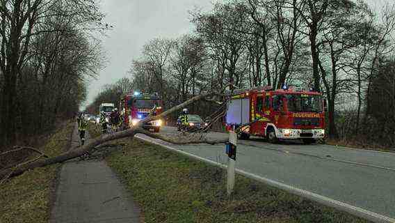
Again and again, emergency services had to move out – especially to salvage fallen trees from the roadways, as here in Aurich.
The storm has kept the fire brigades in suspense since Saturday afternoon. In the East Frisian district of Aurich, trees and construction fences fell, triggering more than a dozen operations.
In Schleswig-Holstein, too, the emergency services were in demand because of fallen trees, loose roof tiles and overturned construction site barriers – especially in the Kiel, Neumünster and Rendsburg areas, where around 200 operations were counted.
The Hamburg fire brigade also had to move out to clear away fallen trees. The Hamburger Verkehrsverbund tweeted that the subways in the outer areas are running at reduced speeds. There were also problems with a fallen tree on line S3.
National Park Administration: Do not enter the Harz Mountains
The DWD is also expecting severe gusts of wind on the Brocken in the Harz Mountains – hurricane gusts are also possible on the 1,141 high summit by Sunday afternoon. The national park administration therefore advises against forest visits beyond the weekend. The hurricane-like gusts pose an acute danger to life, it said. Trees could be uprooted and entire treetops and branches could fall. Efforts will be made to eliminate the damage in the Harz forests in a timely manner, said a spokesman. However, it could be that individual paths are temporarily not accessible after the storm.
Sunday it will be quieter – Monday storm again
“In the night to Monday and on Monday there is a risk of new adversity,” warns the DWD. A low ensures rain and snow above 200 to 400 meters across the country. In addition, stormy winds are blowing, especially in the west and south-west. The changeable and very windy weather will not change in the coming days.
Further information


