It will be stormy this Thursday and Friday! Storm ZOLTAN is bringing changeable and turbulent weather across Germany.
It will be stormy this Thursday and Friday! Storm ZOLTAN is bringing changeable and turbulent weather across Germany. Hurricane-like gusts of over 103 km/h are expected, especially around the coasts, in the higher elevations of the low mountain ranges and in the foothills of the Alps.
Storm Zoltan is currently centered off the coast of Norway and will move over the south of Sweden towards the Baltics in the coming hours. The storm field of the depression extends all the way to Germany. All parts of the country are affected and there are widespread stormy squalls and squalls. These are wind speeds between 62 and 88 km/h. Be especially careful when going outside. You should especially avoid forests today and tomorrow.
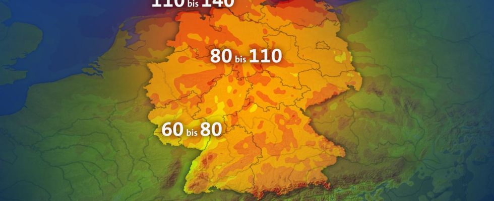
At 10 a.m. this morning, some squalls were already recorded around the North Sea and in southern Germany. In isolated cases, severe squalls have already been recorded in the North Sea. For example, 94 km/h were measured in front of the mouth of the Weser at the old lighthouse. In the Black Forest on the Feldberg there were hurricane-like gusts of 107 km/h and in the Harz on the Brocken hurricane gusts of 126 km/h were measured. The storm will intensify throughout the day. Gusts of between 80 and 110 km/h are expected throughout northwest Germany. So squalls to hurricane-like gusts. Hurricane gusts can occur again and again in the immediate coastal area and in the foothills of the Alps. We expect wind speeds of 110 to 140 km/h here.
However, these wind speeds are not record-breaking. 263 km/h were measured on the Brocken on November 24, 1984. We are still very far from that today. The Zugspitze offers much more. On June 16, 1985, 335 km/h was recorded.
The peak of the storm is in northwest Germany this afternoon and then shifts towards the southeast as it progresses. It will remain stormy on the coasts and at higher altitudes throughout the day. But much of the night will also be restless, although wind speeds will decrease slightly away from the coast. Stormy gusts and isolated severe squalls may still occur. There is currently no all-clear for wind in the immediate coastal area and the Alps.
The ZOLTAN storm field still has us under control on Friday. In the morning there will still be widespread stormy gusts and squalls. On the coasts and in the Alps, as usual, heavy squalls and even hurricane-force winds. From midday onwards, the wind from the northwest decreases significantly, especially in the northeast half. In the southwest half it will remain stormy throughout the day.
The weekend doesn’t bring us much better prospects either. It remains changeable and windy to stormy. However, wind speeds as high as today are no longer expected. On the coasts and in eastern Germany the wind takes a breather, especially on Saturday.