News Weather
This early meteorological spring will be well in season, with new heavy showers circulating in a disturbed and relatively cool ocean flow.
To remember :
A disturbance moves away from the eastern borders and another arrives in the northwest.
– the overall feeling is quite cool with the wind but the values are seasonal
– sustained wind gusts in the northwest, up to 90 km/h at the seaside.
Still sometimes heavy showers in the morning over eastern Corsica.
Evolution compared to the day before
The parade of disruptions continues. They are more active in the western half with stronger winds, while clearings are more beautiful in the east.
Thermal indicator (average temperature over 30 cities in France)
Minimum temperature: 4.9°C
Maximum temperature: 11.3°C
Average temperature: 8.1°C i.e. an excess of +0.7°C compared to normal
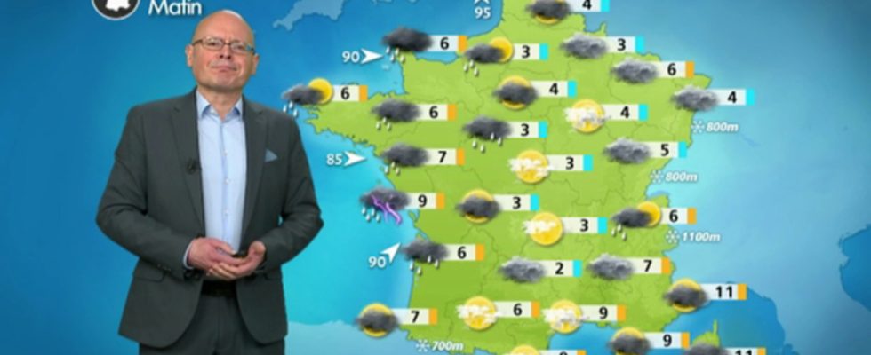
Details by region
In the northwest, from Brittany and Pays de la Loire to Normandy, the weather is disrupted from the morning with heavy rain accompanied by sustained gusts of wind, up to 90 km/h on the coasts. In the afternoon, the disturbance disappears and clearings return.
T°C Min: 6 to 9°C T°C Max: 8 to 11°C
From Centre-Val de Loire and Ile-de-France to Hauts-de-France, the weather gets heavier during the morning as the wind picks up, and it rains in the afternoon. These showers will sometimes be moderate, in an unpleasant atmosphere.
T°C Min: 3 to 5°C T°C Max: 9 to 10°C
From the Grand Est to Burgundy-Franche-Comté and the northern Alps, the disturbance of the night will have given a little rain and fresh snow from 800 m altitude. The Vosges may have received a little dusting. As this disturbance recedes, clearings return and the day is quite pleasant.
T°C Min: 4 to 5°C T°C Max: 10 to 11°C
From New Aquitaine to Limousin and Center-West, the weather is disrupted all day with strong winds (90 km/h by the sea) and fairly heavy rain. The feeling is therefore very gloomy.
T°C Min: 3 to 7°C T°C Max: 8 to 15°C
In Auvergne-Rhône-Alpes, Occitanie and PACA, the day promises to be pleasant with generous sunshine. The sky becomes cloudy in the afternoon over the west and north of Auvergne. After the cool morning, temperatures are quite mild for the season in the afternoon.
T°C Min: 3 to 7°C T°C Max: 10 to 17°C
In Corsica, the weather remains unsettled with stormy showers still frequent.
T°C Min: 7 to 12°C T°C Max: 12 to 14°C
Later development :
The weekend will be degraded with a new active disturbance on Saturday arriving from the Atlantic. We expect further heavy snowfall in our massifs and a risk of flooding to watch out for.