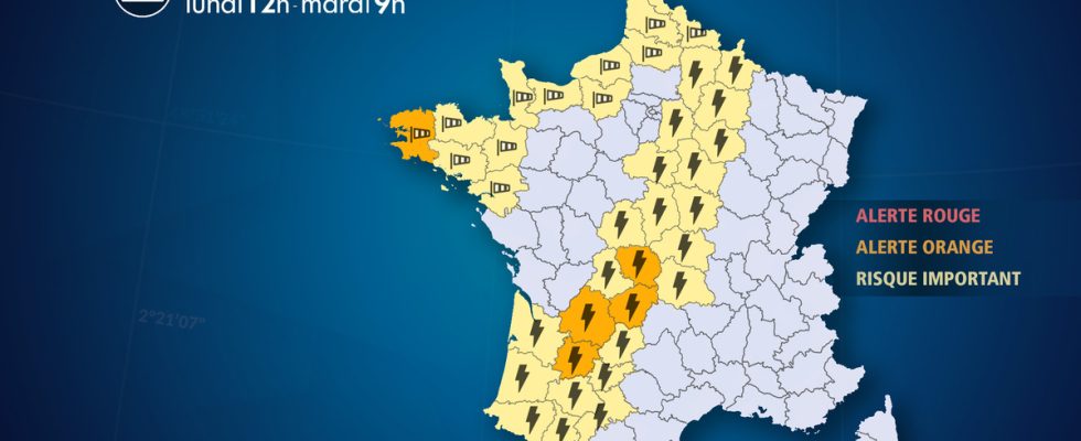
From Monday April 8 at 12:00 to Tuesday April 9 at 9:00.
Complete live weather forecasts by telephone at
3201*
Situation
A depression is forming off the coast of Portugal this Sunday evening. Named Pierrick, this storm, carried by a very dynamic southwest jet stream at 200 km/h, rises very quickly towards Brittany on Monday evening, deepening at 985 hPa. It reaches the North Sea on Tuesday morning via the Channel basin.
This depression causes a strong gale from Brittany to the Channel coasts with gusts which can reach 90 to 110 km/h, occasionally speeds 10 to 20% higher under storm squalls and on exposed capes and coasts.
Due to the high tidal coefficients (110 Monday and 113 Tuesday), the risk of coastal submersion is high during this period at high tide, especially as waves of 4 to 6 meters will propagate from the sea towards the side.
Associated with this depression, a disturbance crosses France from west to east. This disturbance collides with very warm air which rises from the Maghreb to Germany. As a result, thunderstorms form on Monday evening from the Pyrenees towards central France. These storms, occasionally strong, can be accompanied by hail and sudden, brutal winds, particularly in the departments placed in orange.
During the night from Monday to Tuesday, this disturbance quickly reached the northeast of the country where the situation is under surveillance with a risk of heavy stormy rain, requiring an extension of our alert to other departments and regions.
Observation
Monday
At 8 o’clock, the Pierrick depression, responsible for the bad weather to come, is approaching the French coast with heavy showers ahead which are rising over Morbihan and Finistère. In the southwest, the first storms break out between the north of Lot-et-Garonne and Limousin, locally causing heavy rainfall and lightning.
Evolution
Regarding the gale
Monday afternoon, as storm Pierrick approaches, the weather becomes heavy over France with the development of large, threatening cumulus clouds from the Pyrenees to central France. From Normandy to Nord-Pas-de-Calais, brief storms develop. In Brittany, the south wind is strengthening.
Monday evening the real degradation begins. The south wind is rapidly gaining power, reaching 90 to 110 km/h in Brittany, up to 120 km/h on the coasts of the Finistère department placed on orange alert by our services. At the same time, the disturbance is taking place between the Pyrenees and the central regions with storms that are sometimes virulent and occasionally accompanied by hail. The risk of hail is marked in the departments placed on orange alert by our services.
During the night from Monday to Tuesday, the depression sweeps the entire Channel basin with gusts reaching 100 km/h. Initially oriented to the south, the wind turns to the west then to the northwest. Convective gusts of 100 km/h are widespread across the entire Channel basin, up to the Opal Coast at the end of the night.
Tuesday morning, while the wind weakens on the Breton coasts, it remains violent from Normandy to Nord-Pas-de-Calais with gusts in squalls at 90 km/h on the seaside, up to 110 km/h on the capes and exposed ribs. With the shift of the wind to the west and northwest, a coefficient of 110 and waves of 3 to 6 meters coming from the sea, the risk of submersion will become significant at the time of high seas especially as the storm surge reaches 50 to 70 cm.
Tuesday afternoon, the wind will begin to weaken. But, due to the strong instability, powerful convective gusts persist for a few hours from Seine-Maritime to Nord-Pas-de-Calais.
Regarding storms
Monday afternoon, brief storms break out from Normandy to Hauts-de-France.
It’s Monday evening that the situation is the most delicate. Indeed, strong storms are developing from the Pyrenees to the center of the country with a risk of significant hail and gusts of 90 km/h due to a significant air mass conflict, causing risks of agricultural damage. At the end of the evening, these storms move up to the Ardennes as the cold front passes. These storms are organized online. They can also be accompanied by hail and gusts of 80 km/h in the yellow departments of the northeast.
During the night from Monday to Tuesday, storms reach the regions east of the Rhône and the Saône during the night from Monday to Tuesday. It is then sometimes stormy rain which is not of an aggravating nature.
Tuesday morning, heavy stormy rains are concentrated from Franche-Comté to Rhône-Alpes. Total rainfall (up to 30 to 50 mm) is expected to be quite significant. Due to saturated soils, these new rains present risks of hydrological reactions (floods, floods). The situation is also under surveillance for Provence Alpes Côte d’Azur where a fairly significant stormy spell is likely to occur. In the mountains, heavy snowfall is expected from 1,300 meters above sea level in the Alps, which could increase the risk of avalanches.
Tuesday afternoon, the disturbance will evacuate towards Italy and Switzerland and the precipitation will weaken. But, with the plunge of cold air into the Mediterranean, the mistral and tramontane will take over from the rains and storms. They will blow violently from Tuesday evening to Wednesday morning, with gusts reaching more than 90 km/h from the lower Rhône valley to the Camargue to the Provencal coast as well as in the Roussillon plain to the Narbonne region.
List of departments concerned
- 02 -Aisne
Thunderstorms – Significant Risk
- 03 – Allier
Thunderstorms – Significant Risk
- 08 – Ardennes
Thunderstorms – Significant Risk
- 10 – Dawn
Thunderstorms – Significant Risk
- 14 – Calvados
Wind – Significant Risk
Submergence – Significant Risk
- 18 – Dear
Thunderstorms – Significant Risk
- 19 – Corrèze
Thunderstorms – Orange Alert
- 22 – Côtes-d’Armor
Wind – Significant Risk
Submergence – Significant Risk
- 23 – Dig
Thunderstorms – Orange Alert
- 24 – Dordogne
Thunderstorms – Orange Alert
- 27 – Eure
Wind – Significant Risk
- 29 – Finistère
Wind – Orange Alert
Submergence – Orange Alert
- 31 – Haute-Garonne
Thunderstorms – Significant Risk
- 32 – Gers
Thunderstorms – Significant Risk
- 33 – Gironde
Thunderstorms – Significant Risk
- 35 – Ille-et-Vilaine
Wind – Significant Risk
- 36 – Indre
Thunderstorms – Significant Risk
- 40 – Landes
Thunderstorms – Significant Risk
- 44 – Loire Atlantique
Wind – Significant Risk
- 45 – Loiret
Thunderstorms – Significant Risk
- 46 – Batch
Thunderstorms – Significant Risk
- 47 – Lot-et-Garonne
Thunderstorms – Orange Alert
- 50 – Sleeve
Wind – Significant Risk
Submergence – Significant Risk
- 51 – Marne
Thunderstorms – Significant Risk
- 56 – Morbihan
Wind – Significant Risk
- 58 – Nièvre
Thunderstorms – Significant Risk
- 59 – North
Wind – Significant Risk
- 62 – Pas-de-Calais
Wind – Significant Risk
Submergence – Significant Risk
- 63 – Puy de Dome
Thunderstorms – Significant Risk
- 64 – Pyrénées-Atlantiques
Thunderstorms – Significant Risk
- 65 – Hautes-Pyrénées
Thunderstorms – Significant Risk
- 76 – Seine-Maritime
Wind – Significant Risk
Submergence – Significant Risk
- 77 – Seine et Marne
Thunderstorms – Significant Risk
- 80 – Sum
Wind – Significant Risk
Submergence – Significant Risk
- 82 – Tarn-et-Garonne
Thunderstorms – Significant Risk
- 87 – Haute-Vienne
Thunderstorms – Significant Risk
- 89 – Yonne
Thunderstorms – Significant Risk