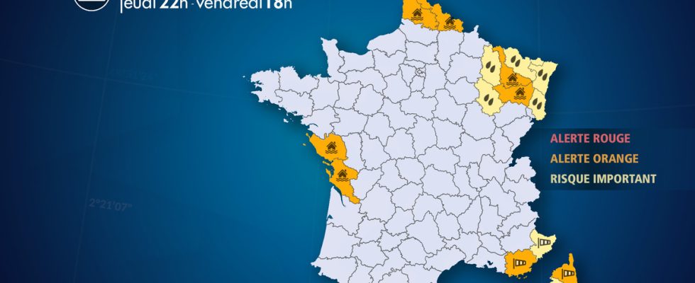
From Thursday November 16 at 10:00 p.m. to Friday November 17 at 6:00 p.m.
Complete live weather forecasts by telephone at
3201*
Situation
The depression named Frederico evacuates the country from the northeast. The wind is losing its power except in the extreme south-east and Corsica where it will blow like a storm until Friday morning. In the Var and the Alpes-Maritimes, peaks of 130-150 km/h are expected on the hills most exposed to the northwest wind. In the east of the Var, violent gusts of 120-130 km/h are likely to sweep through the inland valleys and even into the Gulf of Saint-Tropez. In Corsica, violent gusts of wind could reach 160-180 km/h on Cap Corse, 130 to 150 km/h in Balagne and on the Corsican mountains.
Observation
First part of the night from Thursday to Friday, the wind blows violently in the south-east with 153 km/h in Saint-Cézaire-sur-Siagne (06), 139 km/h on Île Rousse (2B), 134 km/h in Cagnano (2B), 127 km/h in Dramont (83), 113 km/h in Péone (06) and 104 km/h in Fréjus (83).
Total rainfall in 24 hours reached 60 mm in Sewen (68), 58 mm in Basslon d’Alsace (68), 52 mm in Wangenbourg (67), 41 mm in Gérardmer (88).
Evolution
Tonight, it is in the extreme south-east and Upper Corsica that the wind will blow the most violently. In the Var and the Alpes-Maritimes, peaks of 130-150 km/h are expected on the hills most exposed to the northwest wind. In the east of the Var, violent gusts of 120-130 km/h are likely to sweep through the inland valleys and even into the Gulf of Saint-Tropez. In Corsica, violent gusts of wind could reach 160-180 km/h on Cap Corse, 130 to 150 km/h in Balagne and on the Corsican mountains.
On this episode of strong winds and heavy rain, we are waiting :
– gusts of more than 100 km/h on the Vosges terrain
– gusts of 120 to 150 km/h on the reliefs of the Var and the Alpes-Maritimes
– gusts of 100 to 130 km/h in the plains in the east of the Var, up to the Gulf of Saint-Tropez
– gusts of 130-150 km/h in Balagne and 170-180 km/h on the Corsican Cap
– cumulative rainfall of 40 to 70 mm over part of Lorraine and locally 80-100 mm over the Vosges terrain with a risk of floods and floods.
List of departments concerned
- 06 – Alpes-Maritimes
Wind – Significant Risk
- 17 – Charente Maritime
Floods – Orange Alert
- 2A – South Corsica
Wind – Significant Risk
- 2B – Upper Corsica
Wind – Orange Alert
- 52 – Haute-Marne
Precipitation – Significant Risk
- 54 – Meurthe-et-Moselle
Precipitation – Significant Risk
Floods – Orange Alert
- 55 – Meuse
Precipitation – Significant Risk
- 57 – Moselle
Precipitation – Significant Risk
- 59 – North
Floods – Orange Alert
- 62 – Pas-de-Calais
Floods – Orange Alert
- 67 – Bas-Rhin
Precipitation – Significant Risk
- 68 – Haut-Rhin
Precipitation – Significant Risk
- 83 -Var
Wind – Orange Alert
- 85 – Vendée
Floods – Orange Alert
- 88 – Vosges
Precipitation – Significant Risk
Floods – Orange Alert

