From Saturday May 11 at 6:00 p.m. to Sunday May 12 at 9:00 p.m.
Complete live weather forecasts by telephone at
3201*
Situation
After a hot summer day and in contact with a mass of humid air arriving via the Bay of Biscay, occasionally strong thunderstorms broke out in the southwest of the country this Saturday evening, particularly in Aquitaine. These storms move very quickly, but they can occasionally be accompanied by a risk of hail and gusts of 80 km/h. Tomorrow Sunday, as a depression approaches from the Atlantic, a new stormy deterioration affects the central regions up to the north of the country in the afternoon and evening. These storms are expected to be quite strong from time to time from Normandy north of Paris to Picardy and Champagne. These storms can occasionally be accompanied by a risk of hail and gusts of 80 km/h.
In the context of this Ascension Bridge conducive to outdoor activities, be careful if you find yourself in these regions placed on alert by our services.
Observation
This Saturday evening, storms come up from the Pyrenees-Atlantique and cross the Landes as well as the north of the Hautes-Pyrénées. They are scattered, but very electric. Hail was observed in Pau (64). Under the strongest storms, more than 30 mm of water fell in a few minutes around Pau where urban runoff was reported.
At 15h, the heat reaches its peak in Aquitaine where the 30°C mark is close to or exceeded between the Pyrénées-Atlantiques and Gironde with 30°C in Bordeaux, Mont-de-Marsan, Pau and Dax, up to 32°C in Begaar. The storms which break out in the north-west of Spain are progressing towards the French border.
At 12, the heat increases rapidly in the southwest. 25°C is well exceeded in the south of Aquitaine, between Biarritz and Pau. Thunderstorms break out in the northwest of Spain. Ahead, the sky is veiled over the south of Aquitaine where the atmosphere becomes heavy.
Evolution
Tonight, from 6 to 11 p.m., storms circulate very quickly from the Pyrenees to Aquitaine. These storms are occasionally strong and accompanied by a risk of hail. They rise quickly from the Pyrénées-Atlantiques to the Gironde where they lose intensity.
Tonight and Sunday morningstorm activity declines rapidly in the southwest while sustained rains are organized from Pays de la Loire to Center-Val de Loire.
Sunday afternoon, a new stormy offensive is being organized from the central regions of Normandy and Picardy to the Paris basin and Champagne. These storms are scattered, but they occur in a heavy atmosphere. It is between the end of the afternoon and the middle of the evening that these storms are expected to be strongest and occasionally accompanied by a risk of hail in these regions.
From late Sunday eveningthese storms weaken as they reach Alsace and Lorraine, which is why this special press release will be lifted.
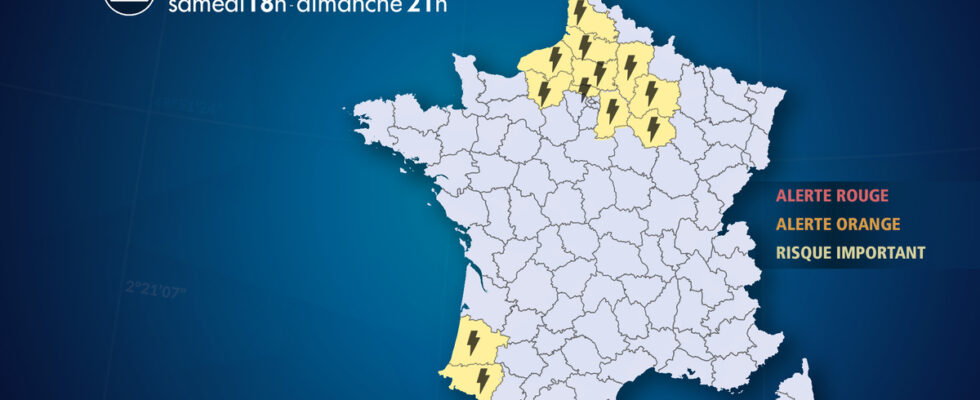
List of departments concerned
- 02 -Aisne
Thunderstorms – Significant Risk
- 10 – Dawn
Thunderstorms – Significant Risk
- 27 – Eure
Thunderstorms – Significant Risk
- 40 – Landes
Thunderstorms – Significant Risk
- 51 – Marne
Thunderstorms – Significant Risk
- 60 – Oise
Thunderstorms – Significant Risk
- 62 – Pas-de-Calais
Thunderstorms – Significant Risk
- 64 – Pyrénées-Atlantiques
Thunderstorms – Significant Risk
- 76 – Seine-Maritime
Thunderstorms – Significant Risk
- 77 – Seine et Marne
Thunderstorms – Significant Risk
- 80 – Sum
Thunderstorms – Significant Risk
- 95 – Val d’Oise
Thunderstorms – Significant Risk