From Thursday March 28 at 9:00 a.m. to Thursday March 28 at 6:00 p.m.
Complete live weather forecasts by telephone at
3201*
Situation
France is located in a strongly depressed context linked to the deepening of a depression named Nelson on the British Isles, up to 955 hPa. It brings lastingly turbulent weather to a large part of the country with a succession of disturbances for this weekend.
Observation
At 9:00 a.m., an extremely violent gust of wind was recorded at the Pointe du Raz on the Breton tip with 183 km/h as a stormy squall passed. We also observed 139 km/h at Pointe Saint-Mathieu. On the Morbihan islands, there are 110 km/h at Belle-île and 114 km/h at Groix. On the island of Ré in Charente-Maritime, the wind reached 121 km/h in Saint-Clément-des-Baleines. Finally inland, we observe 95 km/h in Brest, 92 km/h in Quimper.
At 7:00 a.m., very unstable weather affected the Atlantic coast with violent gusts of wind on the most exposed coasts. In Finistère, we observed 133 km/h at Pointe Saint-Mathieu, 128 km/h at Pointe du Raz, 108 km/h at Saint-Clément-des-Baleines on the island of Ré (Charente-Maritime), 107 km/h on Belle île (Morbihan) 100 km/h in Groix (Morbihan) and 88 km/h in Brest (Finistère).
Evolution
This morning, the wind strengthens significantly on the Breton tip with gusts up to 130-140 km/h. Strong gusts also affect the coast between Morbihan and Charente-Maritime with 100 to 120 km/h, locally 130 km/h. The sea is clearly choppy in the Mediterranean with a risk of submersion on the coasts of Provence linked to the strong southwest wind. Indeed, a swell of 3 to 4 m will suddenly circulate between Corsica and the continent between late night and mid-morning, potentially causing strong waves on the coastlines facing the southwest.
This afternoonconditions become less degraded over the hours over Brittany and the Atlantic arc while the swell strengthens near the southern coast of Corsica with waves of 3 to 5 m.
Throughout the episode, we wait :
– maximum gusts of 90 to 110 km/h inland and 100 to 140 km/h on the coasts
– cumulative precipitation of 30 to 50 mm in western Brittany, up to 60 mm on the hills of the Monts d’Arrée and the Montagne Noire on the southern slope.
– a swell of 8 to 9 m off the coast of Finistère, 5 to 7 m on the Atlantic coast, 3 to 5 m in the Mediterranean
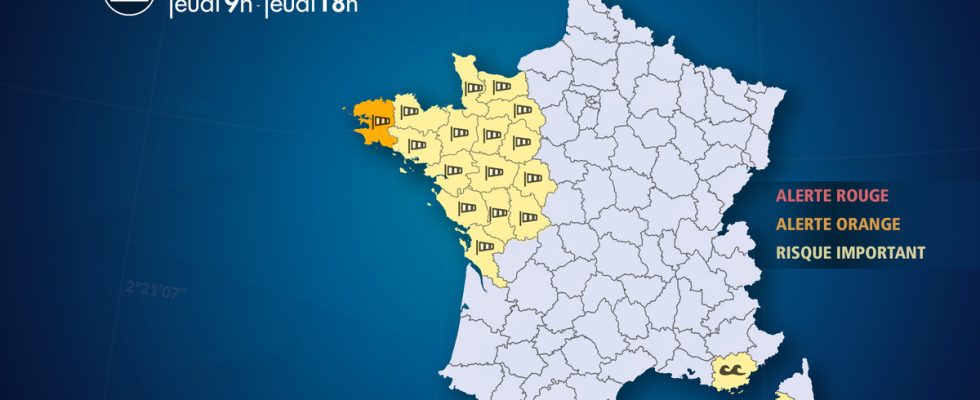
List of departments concerned
- 14 – Calvados
Wind – Significant Risk
- 17 – Charente Maritime
Wind – Significant Risk
Submergence – Significant Risk
- 2A – South Corsica
Submergence – Significant Risk
- 22 – Côtes-d’Armor
Precipitation – Significant Risk
Wind – Significant Risk
Flooding – Significant Risk
- 29 – Finistère
Precipitation – Significant Risk
Wind – Orange Alert
Flooding – Significant Risk
Submergence – Significant Risk
- 35 – Ille-et-Vilaine
Wind – Significant Risk
- 37 – Indre-et-Loire
Wind – Significant Risk
- 44 – Loire Atlantique
Wind – Significant Risk
Submergence – Significant Risk
- 49 – Maine-et-Loire
Wind – Significant Risk
- 50 – Sleeve
Wind – Significant Risk
- 53 – Mayenne
Wind – Significant Risk
- 56 – Morbihan
Precipitation – Significant Risk
Wind – Significant Risk
Flooding – Significant Risk
Submergence – Significant Risk
- 61 – Orne
Wind – Significant Risk
- 72 – Sarthe
Wind – Significant Risk
- 79 – Two Sevres
Wind – Significant Risk
- 83 -Var
Submergence – Significant Risk
- 85 – Vendee
Wind – Significant Risk
Submergence – Significant Risk
- 86 – Vienna
Wind – Significant Risk