
“The sea is the greatest museum in the world,” said archaeologist Salomon Reinach in 1928. It is not Bruno Jonin who will say the opposite. This diving instructor has been exploring the seabed in Brittany for nearly fifty years. Passionate about history, the diver from Guilvinec (Finistère) is also a wreck hunter. “I want to know the story behind these bits of scrap metal that sleep at the bottom of the water,” he says. To know the reasons for the sinking, the mechanics of these ships and the human stories behind it”.
Brittany offers him a formidable playground for this, since the Hydrographic and Oceanographic Service of the Navy (Shom) has identified more than 1,330 wrecks in the Breton seabed. “It’s a real marine cemetery, assures Bruno Jonin. And there is still so much to discover. I think our great-great-grandchildren will still find wreckage.”
“To pay tribute to the missing sailors”
Our Bigouden diver not only admires and photographs the old carcasses lying at the bottom of the sea. With his colleague Eric Le Gall, based in Lorient, he has also embarked on a real work of memory. For several decades, these two underwater archeology enthusiasts have been publishing maps that locate wrecks and detail the reasons for the sinking as well as the human toll. “It’s our way of paying tribute to these missing sailors,” says Bruno Jonin. Because behind every wreck, there are human tragedies”.
Their first map focused on the area from Penmarc’h to Trévignon, including the Glénan archipelago, which is full of boat skeletons. Helped by other diving enthusiasts, gathered within the Society of Archeology and Maritime Memory (Samm), the two friends now have around fifteen published maps, from the bay of Saint-Malo to the coasts of Trégor via the island of Groix.
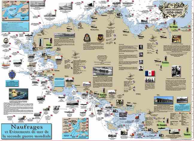
A map of WWII shipwrecks
Their latest achievement focuses on the 300 ships and planes that sank off the coast of Brittany during the Second World War. Like the Nazi submarine U767, bombarded by five Royal Navy destroyers on June 18, 1944 near the island of Bréhat with 49 men on board. Where the Tera French steam trawler sunk by Allied aircraft on March 14, 1944 off the southern tip of Finistère.
“We often talk about the Normandy Landings, but the battle was also very tough at sea in Brittany”, indicates Bruno Jonin, proud to participate in “this inventory of marine heritage”.