As of: October 20, 2023 7:52 a.m
Because the wind blows strongly from the east, people on the Baltic Sea coast have to prepare for floods. The peak of the storm surge is expected this evening, the hotspot is Flensburg. On the North Sea, the consequences of the storm are completely different.
Schleswig-Holstein has to prepare for a severe storm surge on the Baltic Sea coast. On the entire coast, the water level will rise 1.50 meters or more above the mean high water, said the Federal Maritime and Hydrographic Agency (BSH). In the Flensburg Fjord, water levels will reach up to two meters above normal by midday on Saturday. “The last time there was such a flood there was in 1904,” said Ines Perlet-Markus from BSH. In Mecklenburg-Western Pomerania, the flood will only reach the level of a severe storm surge near the Bay of Lübeck.
Goldschmidt calls for precautionary measures
Schleswig-Holstein’s Environment Minister Tobias Goldschmidt (Greens) appealed to coastal residents to be well informed and take appropriate precautionary measures. With a possible duration of up to 40 hours, the storm surge could last significantly longer than similar severe weather events in 2017 and 2019. The German Weather Service (DWD) issued an official severe weather warning of hurricane-like gusts on parts of the Baltic Sea coast, on Heligoland and the East Frisian Islands. It applies from this morning until Saturday night.
The hotspot is the Flensburg Fjord
The storm surge is expected to reach its peak this evening, the hotspot is Flensburg. On Thursday afternoon, the streets at the harbor affected by the flood were closed. By early afternoon the water was already climbing over the edge of the quay. The city called for vehicles parked near the water to be moved away. On Saturday night, citizens were asked not to leave their houses and apartments: because of the storm, falling roof tiles or breaking branches should be expected, according to the city. This morning the city of Schleswig also issued danger information: As the water levels of the Schlei rose, streets were flooding. Some roads near the water were closed.
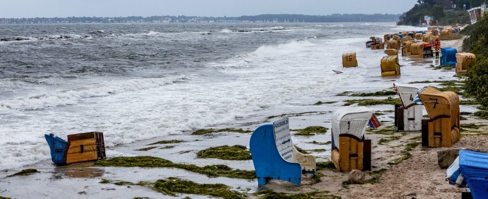
Flooding also on Baltic Sea beaches
A water level of up to 1.70 meters above normal is also expected in the Bay of Lübeck. The BSH predicts values of up to 1.80 meters for the Bay of Kiel. There is also a risk of flooding on the Baltic Sea beaches. Walkers should be particularly careful on the cliffs – there could be crashes due to strong waves and high water levels.
Further information
Hurricane-like gusts possible on the coasts
From this morning, hurricane-like gusts of up to 110 kilometers per hour can be expected on the Baltic Sea coast, on Helgoland, the East Frisian Islands and on Rügen. “We are dealing with a stable wind field, which causes the entire Baltic Sea to move,” explained BSH expert Perlet-Markus.
According to the DWD, heavy, continuous rain can be expected in Schleswig-Holstein, Hamburg and Lower Saxony today. Rainfall amounts of between 25 and 40 liters per square meter are expected in Schleswig-Holstein. The wind and rain only subside on Saturday night.
Wismar warns its port residents
There is also said to be an exceptional flood situation on the Baltic Sea coast in Mecklenburg-Western Pomerania. The Baltic Sea water level in the port of Wismar rose faster than expected on Thursday afternoon to 95 centimeters above the mean water level. For today, the BSH expects the water level to be up to two meters above sea level. That would be the water level that caused flooding in the harbor and parts of the old town in January 2019. The City of Wismar therefore calls on the people who live at the port to take protective measures. They should drive vehicles out of the flood-prone area. Sandbags have also been made available since Thursday afternoon.
West of Rügen, water levels of up to 1.50 meters above normal can be expected until midday on Saturday. Values of up to 1.20 meters are expected on the eastern coast of Rügen. According to the BSH, increased water levels of up to 1.10 meters can be expected in the inner coastal waters. Values of up to 1.50 meters can be reached in the Greifswalder Bodden and up to 1.10 meters on the Stettiner Lagoon.
Greifswald: Middle segment of the barrage closed
According to the local fire department, the middle segment of the barrage in Greifswald was closed on Thursday afternoon. After a visit to the Wieck district, the situation was still assessed as relaxed, so that the two side segments could remain open for the time being. In the afternoon a water level of 5.95 meters was measured, 90 centimeters above normal. According to the forecasts, a significantly higher water level should be expected, it was said. However, the maximum level is not expected there until Saturday night.

VIDEO: Wind from the east: Will the flood also come to MV? (10 mins)
Denmark: Holidaymakers should leave the coastal area
People in Denmark and Sweden are also preparing for the storm. Residents and holidaymakers on the Baltic Sea coast in the south and east of Denmark should leave the coastal area by this morning at the latest. The Danish police called for this on Thursday. The summer house areas on the southern coasts of the islands of Lolland, Falster and Funen as well as in the fjords of Haderslev, Aabenraa and Flensburg, which are popular with German holidaymakers, are among those affected.
The Danish Meteorological Institute (DMI) warned of flooding in the affected coastal areas from this morning until Saturday afternoon. The water level could rise up to 2.40 meters above normal, the DMI said. The responsible authority also predicted floods for the Swedish southern coast.
Ferry cancellations to North and Baltic Sea islands due to low water

Extremely low water levels will disrupt the timetables of some North Sea ferries.
Islanders and autumn vacationers on Lower Saxony’s North Sea coast will have to prepare for postponements and cancellations of ferries to and from the East Frisian Islands in the coming days. Significantly lower water levels are expected there due to the easterly wind. In Cuxhaven, for example, there are expected to be water levels of more than 1.50 meters below the usual average low water level today, as the BSH announced on Thursday. According to the information, the water level on the German North Sea coast has only fallen below the value of 1.50 meters below the mean low water three times in the past 25 years – twice in March 2018 and once in November 2022. That’s why the ferries are sometimes unable to drive more.
Ferry traffic to the islands of Juist, Baltrum and Spiekeroog will be completely stopped today. Ferries to and from Wangerooge do not run until Saturday. The operator Deutsche Bahn announced that further restrictions are also to be expected on Sunday due to the strong easterly wind. Ferry companies along the coast are also reporting changed departures or cancellations for the islands of Borkum, Norderney and Langeoog. The Elbe ferry Glückstadt-Wischhafen is also completely ceasing operations today.
The water levels on the Schleswig-Holstein North Sea coast are also expected to be well below normal values by Saturday. The shipping companies have therefore announced cancellations and postponements for connections to islands and Halligen.
On the Baltic Sea coast in Mecklenburg-Western Pomerania, the Hiddensee shipping company announced that it would stop all ferry operations today. Numerous departures on the Rostock-Gedser line of the ferry company Scandlines are also canceled up to and including Saturday morning.
The weather will only improve on Monday
There is hardly any significant improvement in the weather in sight in the next few days. Although the wind will die down on Saturday morning, “but precipitation will continue to appear,” predicts Tobias Schaaf from the DWD. The sun will hardly play a role, but it will be milder with temperatures of 14 to 16 degrees. There will be a somewhat friendlier interlude on Monday. But the DWD doesn’t hold out much hope for a lasting improvement: things are expected to remain changeable next week.
Further information


