storm
Storm Ciaràn is raging in North Rhine-Westphalia: These maps show where the wind is strongest today
Wind gusts of up to 100 kilometers per hour are raging in North Rhine-Westphalia. The maps in the article show where the strongest gusts occur
© wetter.de
Hurricane Ciaràn moves across Europe. The storm left a particularly big impact in France. But the hurricane could also have an impact in North Rhine-Westphalia.
The German Weather Service (DWD) warns of severe weather on Thursday North Rhine-Westphalia. There is no severe weather warning yet. However, some localities are already reporting fallen trees and demolished cars. Hurricane-like gusts of more than 100 km/h were already recorded in the Eifel this morning. The fire brigade is constantly on duty to repair the damage. Hurricane-like wind speeds are expected to remain outliers in North Rhine-Westphalia today.

The maps below provide an overview of the weather situation:
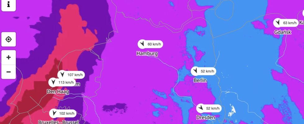
Map I: Where wind speeds are highest
The map above shows the wind speeds in Germany. The view is provided by the portal wetter.de, which, like stern, belongs to RTL Deutschland. Clicking on the map leads to wetter.de.
Map II: Storm warnings for today
The map above shows the thunderstorm warnings for today according to DWD. The view is also provided by the wetter.de portal.
Map III: See live where squalls are currently occurring
The interactive map below shows where gusts are currently occurring. You can also view the forecast for a later date using the timeline at the bottom of the graphic. At the top right, the level displayed can be changed to, for example, thunderstorms.
The service is provided by Windy.com. The makers use the model from the “European Center for Medium-Range Weather Forecasts” for their representations and forecasts.
Climate change
What the weather was like in Germany 50 years ago – and what it will be like in 2070
In the gallery: Was the weather in the 1970s like it is today? No. Even if some people feel otherwise: the data is crucial. And they also point to the future.