After Pas-de-Calais, which has been facing floods for several days, Haute-Savoie is in turn affected by significant rainfall. Tuesday evening, Météo-France placed the department on red alert for floods, particularly for the rise in the level of the Arve, a river which crosses the department. The Arve downstream sector was particularly concerned, notably the municipalities of Gaillard, Annemasse and Etrembières. On the morning of this Wednesday, the territory returned to orange. Exceptional weather event, people evacuated, roads cut… 20 minutes takes stock of the situation.
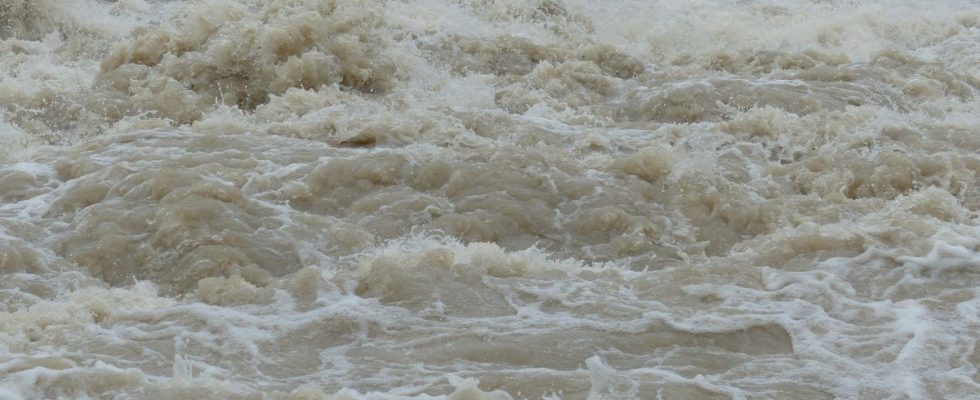
The Arve burst its banks and around a hundred people evacuated
According to information from France Bleu Pays de Savoie, the Arve river burst its banks on Tuesday evening in Sallanches and Magland. It had an “exceptional” flow rate of 1,100 cubic meters per second. This Wednesday morning, it is especially the agglomeration ofAnnemasse which was affected, as well as Etrembières, where around fifteen residents were invited to take refuge on the first floor of their homes, with water rising up to 90 cm. In the same town, 300 homes are without electricity due to falling trees and flooding.
Also according to local radio, around thirty people were evacuated by boat after the water passed over the bridge in the hamlet of Pont-Neuf, in Reignier-Ésery. The residents were woken up around 4 a.m. by firefighters to “rescue” them with “a boat”, according to the testimony collected.
In total, nearly 200 interventions have been carried out by the Haute-Savoie firefighters since Tuesday evening, with the treatment of 110 people overnight. The prefecture clarified that no victims were reported.
Cut roads and isolated villages
The mountain villages of Argentières, Vallorcine and Reposoir are isolated due to roads cut by mudslides or rockfalls, the prefecture said. In these areas, more than 200 mm of rain fell in forty-eight hours.
“We have no human damage yet, no flooded houses like in Pas-de-Calais,” explained the mayor of Sallanches. The water overflowed but on plains, in places that were not too impactful, perhaps some electrical damage to the treatment plant.” The basements of the city hospital were flooded, but pumps were installed and no patients had to be evacuated.
A “centennial flood” which should calm down this Wednesday
At the microphone of France Bleu this Wednesday morning, the prefect of Haute-Savoie, Yves Le Breton, specified that the Arve was in “a hundred-year flood, therefore very violent, very brutal, but with fairly rapid evacuation”. “Since Tuesday, we have been facing an exceptional climatic event with very heavy precipitation at altitude, accompanied by the melting of the snow that had already fallen before,” he added. Wednesday “should be calmer than the previous one”, he continued, expecting a decline. The prefect nevertheless insisted on the need to remain “cautious” about “possible land movements and mudslides” which could occur.
“We expect rockfalls and landslides,” said Martial Saddier, president of the Haute-Savoie departmental council, also interviewed by local radio. For the elected official, the time of recession will also be that of taking stock, where it will be possible to discover “the dikes washed away”, “piles of battered bridges”. He also called for “extreme vigilance” around rivers in the coming days, to allow time to assess whether there is no longer any danger.
And elsewhere ?
In Savoie, the Notre-Dame-de-Briançon station is completely flooded and traffic is interrupted between Albertville and Bourg-Saint-Maurice, according to the SNCF. Traffic is not expected to resume today.
In Grenoble, the bank road along the Isère is underwater and closed. The level of the river rose sharply, reaching 3.31 m at 8 a.m. at the Grenoble Bastille station, more than the flood of March 22, 2001, but still far from that of November 2, 1859 (5.23 m), according to Vigicrues. The rising waters should reach their maximum in the middle of the day this Wednesday, at 3.80 m.