As of: December 22, 2023 5:51 a.m
The German Weather Service (DWD) continues to warn of storm “Zoltan”. Hurricane-like gusts are possible on the coasts and islands until tomorrow. A severe storm surge is expected this morning. There are cancellations and delays in rail transport.
One applies to the coasts of northern Germany until tomorrow evening storm warning. According to the DWD, heavy, continuous rain and hurricane-like gusts can be expected until then. There is therefore a risk of hurricane gusts of level 3 out of 4 on the Brocken in the Harz Mountains. In the rest of northern Germany there can be severe squalls. This morning, the DWD is expecting gusts on the North and Baltic Sea coasts that can reach speeds of 90 to 110 kilometers per hour; stronger hurricane gusts are possible. It is also expected to remain stormy in the rest of Northern Germany for the time being.
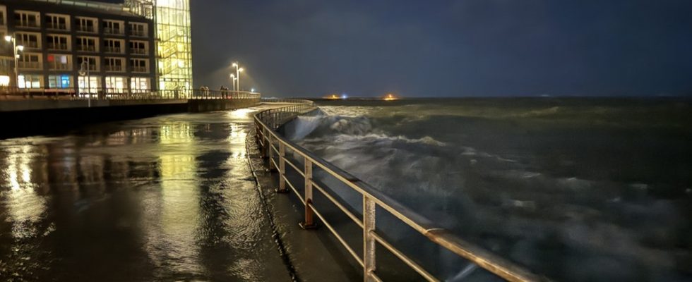
Severe storm surge expected
The port of Helgoland was already flooded on Thursday. A severe storm surge is expected today.
There is a risk of a severe storm surge for the German North Sea coast and Hamburg. In the Elbe area of Hamburg, the police warned of a severe storm surge in the morning. According to the Federal Maritime and Hydrographic Agency (BSH), the water levels will then rise to around three meters above mean high water. According to police, the affected area should be avoided. According to the information, the flood peak is expected at around 11 a.m. at the St. Pauli gauge with a height of up to 3.05 meters above the mean flood level. The BSH also predicts severe storm surges for the East Frisian coast and the Weser area. Flood waters there are expected to be 2.5 meters to 3 meters above average in the morning and midday. On the North Frisian coast, water levels of 2 meters to 2.5 meters above mean high water are expected.
Further restrictions on rail traffic
videos

Deutsche Bahn expects further restrictions on passenger transport today. Yesterday there were numerous cancellations and delays in regional and long-distance transport due to the storm damage. “In some cases, damage can only be finally assessed in daylight,” said a railway spokesman. According to initial information, long-distance trains between Hamburg/Hannover, Kassel and Frankfurt/Stuttgart/Basel as well as Würzburg and Munich are canceled today. There are delays and isolated cancellations between Berlin/Leipzig/Erfurt and Frankfurt. ICE and IC trains do not stop in Marienhafe, Norden, Norddeich and Norddeich Mole. The EC train routes in Hamburg and Schleswig-Holstein are also affected.
Failures also in regional transport
There were also weather-related delays and cancellations in regional transport yesterday, which continued into Friday night. There is still no train service possible on the routes between Hamburg, Flensburg and Kiel that were closed on Thursday, according to a Deutsche Bahn post on platform Then, according to the DB, a tree fell onto the overhead line between the Kiel and Neumünster stations. The regional trains between Hamburg and the island of Sylt, however, are running again. However, there could still be delays and partial cancellations due to weather conditions, the railway said. Travelers should check their connection before traveling.
Deutsche Bahn also announced that the train connection had been lifted for Thursday and Friday. Passengers could use their ticket on a later day. However, the DB also pointed out that long-distance trains were already very busy due to the upcoming Christmas period. Deutsche Bahn is also expecting restrictions on passenger transport on Friday.
Due to the weather conditions, the Brockenbahn had already stopped operations between Schierke and the Brocken. The Harz narrow-gauge railways said there could also be restrictions in the coming days.
Further information


Storm damage, flooding and traffic disruptions
The storm has been raging over the north since yesterday morning. In Hamburg, the fire department was called out for weather-related operations almost 80 times, as NDR 90.3 reported. In the Altona district, she had to free a man from his car who was trapped by floodwaters. When the car floated open, he could no longer open the door. Dozens of onlookers gathered late on Thursday evening on the steps to the St. Pauli fish market, which had been completely flooded by the storm surge. The water flowed into nearby house entrances, shops and restaurants. According to police, no one was injured in the storm.
In Bremen, a 15 meter high tree fell next to a bus stop. According to the information, no one was injured. In Wilhelmshaven, parts of scaffolding fell over, which is why a street was closed. There were no reports of injuries from there either. In Braunschweig, a person was injured by a falling tree.
In Schleswig-Holstein, the North regional control center reported 42 storm operations in the early evening, the West control center even reported 50. In Flensburg, for example, some roof tiles fell down. After several accidents the… Fehmarnsund Bridge completely closed due to the storm.
Further information


Several ferries are canceled
Due to the stormy weather, travelers also have to be prepared for limited ferry traffic. The shipping company Scandlines is temporarily suspending its trips between Rostock and Gedser in Denmark. Ferry service was expected to resume this afternoon. The shipping company Weiße Flotte also canceled ferry trips. You shouldn’t be running at all today. The Wittow ferry in the north of Rügen also stopped operating. In Rostock, Rostocker Straßenbahn AG (RSAG) stopped operating the Warnow ferry up to and including today.
In Schleswig-Holstein, the Wyker Dampfschiff-Reederei has partially stopped ferry traffic. This affects both the Föhr-Amrum line and the Hallig line. In some cases special timetables apply. All trips between the mainland and the island of Helgoland have also been canceled to date. The ferry from Pellworm to Nordstrand, however, runs according to a special timetable. Travelers to Sylt also have to be prepared for restrictions. According to the shipping company FRS Syltfähre, various connections between Havneby on Rømø and List on Sylt are canceled. Deutsche Bahn’s Syltshuttle does not transport vehicles that are susceptible to wind, such as trucks with empty trailers, dangerous goods or motorcycles. Operator RDC’s car train says it may not be able to carry very light, larger vehicles.
Today the ferry service to and from the East Frisian island of Wangerooge is to be completely stopped, as announced by Deutsche Bahn, which operates the ferry service with a subsidiary.
- Emden – Borkum (AG Ems, ferry, catamaran): Ferry crossings on December 22nd with a delay, catamaran trips are canceled on December 22nd. Current information at: www.ag-ems.de/fahrplan
- Norddeich – Juist (Island ferry): Restrictions on ferry traffic possible on December 22nd. Current information at: www.inselfaehre.de/juist
- Norddeich – Norderney (Frisia island ferry): Restrictions on ferry traffic are possible on December 22nd. Current information at: www.inselfaehre.de/norderney
- Neßmersiel – Baltrum (Baltrum line): Restrictions expected on December 22nd. Current information at: www.baltrum-linie.de/aktuelles-blog/
- Bensersiel – Langeoog (Langeoog shipping): Several crossings are canceled on December 22nd. Current information at: www.langeoog.de/schiffahrt-langeoog/
- Neuharlingersiel – Spiekeroog (Ferry Spiekeroog, Watt’n Express) Several crossings are canceled on December 22nd. Restrictions possible on weekends. Current information at: www.spiekeroog.de/buchen/faehre
- Harlesiel – Wangerooge (SIW Wangerooge and Watt Sprinter) No crossings on December 22nd. Current information at: www.siw-wangerooge.de/siw-de
Christmas markets closed for security reasons

The Bremen Christmas market was closed due to the storm “Zoltan”.
The Christmas markets in Bremerhaven and Bremen remained closed on Thursday for safety reasons. In Hamburg and Schleswig-Holstein, the operators of the Christmas markets initially want to keep their stalls open as planned. “We’ll see how things go in the next few days,” said a spokesman for the Roncalli Christmas market on the town hall market. In Mecklenburg-Western Pomerania, some Christmas markets closed earlier than planned – such as in Neubrandenburg.
Almost certainly not a white Christmas
Weather expert Böttcher told NDR that it should remain rainy and mild at the weekend. The maximum temperature on Christmas Eve on Sunday is expected to be between 4 and 10 degrees Celsius: “So far from freezing. Snow and ice won’t be a big risk.” And that means there will be no white Christmas this year either.
Further information


Keywords for this article
Storm
