As of: October 18, 2023 7:51 p.m
According to the German Weather Service, a storm over Schleswig-Holstein will cause a storm surge in the next two days – and thus high water on the Baltic Sea and low water on the North Sea.
The German Weather Service (DWD) is predicting a storm over Schleswig-Holstein in the coming days. The reason is that a low is moving from the Bay of Biscay over Great Britain to Schleswig-Holstein – and at the same time a high is over Scandinavia, which is blocking the low’s approach. From Wednesday afternoon, the DWD predicts wind gusts of 55 kilometers per hour, stormy gusts of 65 for Thursday morning, and 80 kilometers per hour on Heligoland (Pinneberg district).
Ferries to Amrum, Föhr and Pellworm are canceled
The storm depression means high water for the Baltic Sea coast and low water for the North Sea coast. That’s how they have it Wyker steamship shipping company and Neue Pellwormer Dampfschiffahrts GmbH have already announced that ferry connections, including to Amrum, Föhr and Pellworm (all in the Nordfriesland district), will be canceled up to and including Saturday due to the announced low water levels.
Elbe ferry Glückstadt-Wischhafen partially stops operations
The Elbe ferry between Glückstadt (Steinburg district) and Wischhafen also announced restrictions. On Wednesday, due to low water, the last ferry leaves Wischhafen at 9 p.m. and from Glückstadt at 9:45 p.m. According to the company, ferry traffic will be completely stopped on Thursday from 10:30 a.m. to 2:30 p.m.
BSH water level forecasts for the Baltic Sea coast in SH
According to the Federal Maritime and Hydrographic Agency (BSH) There is a risk of a storm surge until Saturday afternoon. According to its own information, the BSH works with various model forecasts. These are not official water level forecasts.
These are the highs in the forecast until Saturday:
- Flensburg: 1.60 to 1.90 meters on Saturday
- Langballigau (Schleswig-Flensburg district): 1.60 to 1.85 meters on Saturday
- Kalkgrund lighthouse: 1.50 to 1.80 meters on Saturday
- Slime Mouth (Schleswig-Flensburg district): 1.50 to 1.80 meters on Saturday
- Eckernförde: 1.60 to 1.80 meters on Saturday
- Kiel lighthouse: 1.50 to 1.70 meters on Saturday
- Kiel-Holtenau: 1.50 to 1.70 meters on Saturday
- Heiligenhafen (Ostholstein district): 1.30 to 1.45 meters on Saturday
- Marienleuchte on Fehmarn (Ostholstein district): 1.25 to 1.45 meters on Saturday
- Neustadt (Ostholstein district): 1.45 to 1.50 meters on Saturday
- Travemünde: 1.55 to 1.60 meters on Saturday
- Lübeck: 1.50 to 1.60 meters on Saturday
As of: 6:21 p.m. October 18, 2023
Water levels are probably highest in Flensburg
In Flensburg the water levels could therefore rise between 1.60 meters and 1.90 meters on Saturday increase. This means that Flensburg would be most affected by the storm surge. A forecast that Sebastian Wache from the Meeno Schrader weather team agrees with. “The water could even rise to two meters or more. In that case, it would be a very severe storm surge,” says the meteorologist. For comparison: During the last storm surge in January 2019, the water in Flensburg rose to 1.68 meters above mean flood. “At this level we are talking about a severe storm surge,” says Sebastian Wache.
Two peaks expected for Flensburg
The BSH storm surge warning is valid until Saturday afternoon. Sebastian Wache expects two peaks: “The first on Friday night with water levels of 1.40 to 1.50 meters. Then the wind decreases slightly and the water recedes slightly. The second comes on the night from Friday to Saturday with a water level of two meters or even higher.” After that, the situation calmed down: the high moved out of Scandinavia, and the low could move on from Schleswig-Holstein.
The situation in the city of Flensburg is still relaxed on Wednesday. “If this is confirmed with the 1.90 meters on Thursday, we will take further measures if necessary,” says a city spokesman. For example, closing the parking lot at the Flensburg harbor or having cars that are still parked there towed away. The harbor masters then made sure that the boats were secured accordingly.
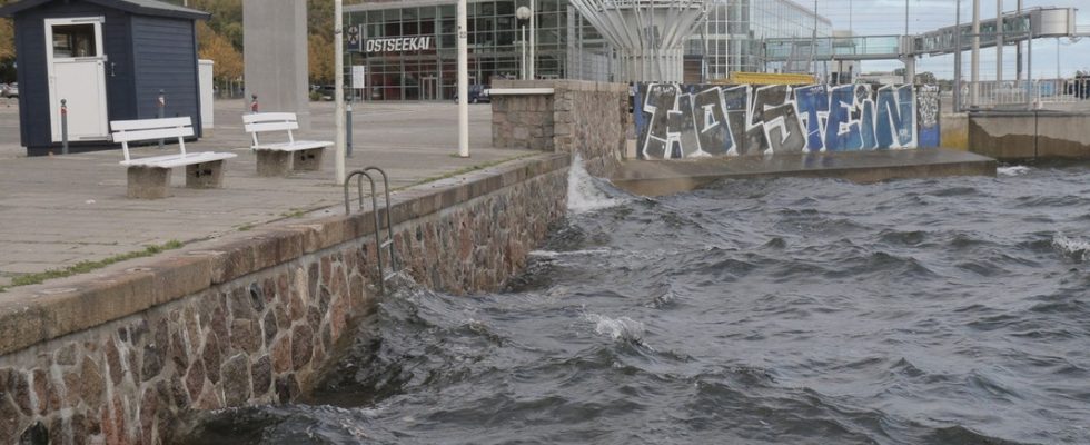
Water is also rising in the Bays of Lübeck and Kiel
According to the BSH on Wednesday afternoon The water in the Bay of Lübeck and Kiel could rise by 30 to 70 centimeters above the average water level as early as Wednesday evening (as of 1:11 p.m.). For Thursday, the BSH models have calculated a flood of between 55 and 110 centimeters in the Bay of Lübeck and between 60 and 130 centimeters in the Bay of Kiel.
City of Eckernförde: People should avoid the area around Eckernförde Bay
The city of Eckernförde (Rendsburg-Eckernförde district) recommends that citizens avoid the affected area around Eckernförde Bay. This includes in particular the spa promenade, the harbor tip, the harbor and the Borbyer Ufer. The city also advises re-parking cars that have been parked in the immediate vicinity of the Baltic Sea and finding parking spaces in higher areas. The city also refers to the German Weather Service’s WarnWeather app.
Further information

