
If you hang out from time to time on Google Earth, the visualization service of our dear planet Earth, or on Google Street View, which allows you to navigate virtually anywhere in the world, you may have already come across images more or less weird or scary. “Proof” of a murder, islands that disappeared in the Pacific, a pentagram in a field, ghosts of children or an unidentified flying object… Since its launch in 2007, the Google Street View service has been making Internet users sensitive to the paranormal talk a lot, nourishing the web’s love of weird stories.
Many of these disturbing images have been the heart of conspiracy theories or at least helped to create new ones. creepypasta, those scary urban legends that circulate on the Internet. It must be said that recently, when Google Street View celebrated its 15th anniversary, a blog post of the Silicon Valley giant indicated that “Street View cars equipped with cameras have captured and shared more than 220 billion images […] and traveled more than 16 million kilometres, the equivalent of going around the world more than 400 times! “. Enough to accumulate some somewhat bizarre shots…
Image bugs
In 2020, an image taken in the park of a cemetery in Texas thus unleashed the canvas. Behind a large tree, a small head appeared, while a hooded figure could be made out in the background of the image… That was all it took to cry phantom. In fact, many web sleuths have found the entity in question to be just a little girl, whose family was photographed having a picnic a little further away… She allegedly got behind the tree as the Street View car, tasked with taking images, passed.
In the same way, for a long time, a thoroughfare in New Baltimore in the State of New York, in the United States, was nicknamed the “haunted street” because it appeared as if it were deformed on Google Maps by an acid trip. A technical bug in image capture that lasted several years: today the street in question looks… perfectly normal.
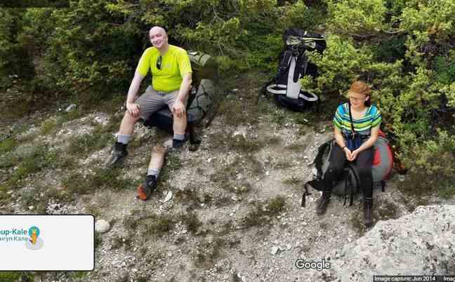
Google Street View’s small mobile cars, equipped with cameras, take snapshots along the way. This sometimes gives rise to overlapping images or inconsistencies, a kind of grain of sand in the matrix.
Thereby, in 2014, a couple is photographed in Crimea as he takes a break in the middle of a hike. With the movement of the cameras, the man found himself with… a third leg. A fairly common bug in reality, given the number of photos taken per minute by Google cars to try to reproduce as much as possible an impression of reality in 360°.
optical illusions
And then there are cases where the vision carried by the cameras of Google Street View is misleading: the wrong angle, the photo in the wrong place and at the wrong time… Enough to give rise to many conspiracy theories, easy to deny.
Like this image captured in Chile in 2013, which continues to resurface on social networks: stacked near a dumpster, disarticulated “bodies”. It will not take more for Internet users to see dead bodies there, when they are simply mannequins thrown in the garbage.
Likewise, the rumor of the image of a flying saucer captured by Google Earth returns quite regularly on the Internet: in the small town of Urseni, in Romania, a cylindrical shape has attracted attention, even appearing in videos conspirators supposed to prove the existence of extraterrestrial life. Lack of luck: the image, taken from above, is just a church…

Another image that terrified the Internet for several years: the overhead photo of a pontoon, taken from above on the side of Almere, in the Netherlands. The wooden dock appears to be covered in a trail of blood, and some even seem to make out the shape of a body in the photo taken by Google Earth. After web sleuths went wild trying to solve this case on Reddit, zooming in and altering the image to show the bloodstains and the face of the potential murderer or victim, netizens realized that the image actually showed… a dog. Rama, the doggie in question, had left his traces on the wooden pontoon while going for a swim, coloring the dock. A hypothesis that some Internet users found it difficult to believe, being convinced that the possibility of murder was still possible…
Those who joke (or make art)
If you walk in the streets of Tokyo on Google Maps, you may come across a whole troop of people decked out in pigeon masks: since 2013, this surprising image has been fairly representative of the jokes made to Google cameras. Masks of all kinds, unusual positions… Everything is good to be immortalized on Google Maps for years.
But these jokes can take a terrifying turn: if you wander around Finland on Google Street View, specifically on the side of Suomussalmiyou may see what appears to be an army of people looking in the same direction in a field, a ritual way of Midsommar. In reality, it is an art installation by Reijo Kela, named SilentPeople, where dressed scarecrows are presented in a field, in particular to evoke loneliness. More than a hundred dolls are presented, and their clothes changed twice a year.
If you are going to explore Google Street View the village of Nagoro, Japanyou will notice that lots of dolls are scattered all over the city : at bus stops, in cafes, on park benches. Nagoro, nicknamed the “village of dolls” or “village of scarecrows”, has become an attraction thanks to Google Maps. These huge human-sized dolls represent all the dead people in the village, and have been made by a grandmother for about ten years. It is even said that today, with the aging of the population, there are more dolls than humans in Nagoro…
The “real mysteries”
Google Street View, Google Earth and Google Maps also cultivate their share of unsolved mysteries, such as the island of Vostok, a triangular island in the middle of the Pacific Ocean, which quickly became a magnet for conspiracy theories after Internet users noticed that it only appeared as a black hole surrounded by sand. As if Google were trying to hide the nature of what is happening there… For some, the island of Vostok was proof that there was an Area 51, or a global conspiracy: in fact, the black hole effect has was created… by trees.
But this is not the first time that certain areas have been hidden or blurred by Google to protect certain spaces: military or war zones at risk are blurred to prevent their use by one side or the other. On Google Maps, some places don’t even appear, such as the island of North Sentinel, off Burma, home to the last population that had no contact with the outside world. Now, on Google’s “Local Guides”, you can even visit haunted places recommended by Internet users, even from his couch. And happy Halloween!