There has not yet been a high pressure situation in Germany that has been stable for several days this spring. That doesn’t change at first.
This week, a low is moving from north-western Europe via France to Italy and another across the North Sea. These lows bring rain in Germany from Tuesday, first in the western half and then on Wednesday in the eastern half. After the rain has subsided, it will remain changeable with showers and brief thunderstorms. At the weekend it will rain more extensively from the south. In the southwest half of Germany, 30 to 50 l/m² of rain is expected up to and including Sunday, and significantly more in the Alps. It gets less wet in the north-east half with mostly 10 to 20 l/m². In the direction of the Oder and Neisse, it will not be 10 l/m² due to the proximity to a stable high over the Baltic Sea. Winter (December to February) brought a lot of rain in the northern half of Germany, March in almost all of Germany. Thus, the topsoil is currently sufficiently moistened throughout the country. The situation has also eased in the deeper layers after several years of drought. Nevertheless, more rain can be used, in the north-east of Germany there is still a lot of water missing in the deeper layers.
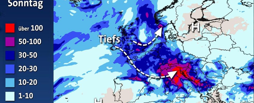
The low will be over northern Italy for several days. For this reason, rainfall of over 100 l/m² can be expected in some regions. It will also be wet in north-west and west Europe. Almost no rain is to be expected under the influence of high pressure around the Baltic Sea and in southwestern Europe. There is an extreme drought in northern Italy. The upcoming rain is urgently needed there. But even in France, where it was very dry recently, everyone gets wet for every rain.