News Weather
This Monday, April 22, don’t expect a softening, on the contrary. Indeed, France remains under the influence of a cold air mass of Scandinavian origin. The kiss accentuates the cold feeling in the wind. Like the weekend, the Atlantic and southern regions benefit from sunnier weather than elsewhere.
Highlights of the day
– a freshness as remarkable as ever and temperatures at a late February level in the east
– there kiss which blows at 50 km/h and accentuates the very cool, even cold feeling over ¾ of the country
– there snow which continues to fall from 600 meters on the eastern reliefs
– of the jellies (0 to -2°C) between inland Brittany, Limousin and the sheltered plains of the southwest, as well as in Auvergne to the Ardennes and Lorraine
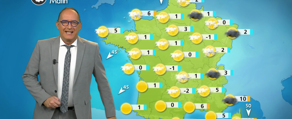
Morning
You have to cover up, because it is cold with many small white frosts. On the sky side, from Pas-de-Calais to the Grand Est to Auvergne-Rhône-Alpes, the weather quickly becomes threatening and windy with snow from 600 in the form of showers in the mountains. In Provence Côte d’Azur and Corsica, the early morning sun is challenged by large cumulus clouds. Everywhere else, the sun shines even if the sky gets heavy near the Channel with coastal showers. The wind still blows just as strongly in the Mediterranean in the form of mistral and tramontane, up to 90 km/h in gusts.
Temperatures from -1°C in Aurillac to 10°C in Ajaccio passing through 0° in Rennes, 1°C in Nancy, Rouen and Toulouse, 3°C in Paris and 7°C in Nice to Perpignan.
Afternoon
In an atmosphere which remains cool, even cold because of the north wind, a few showers are circulating near the Channel as well as Hauts-de-France in the East Center and the Alps with snow from 500 to 800 m. In Provence Alpes Côte d’Azur and Corsica, the weather is deteriorating with occasional stormy showers. The mistral blows strongly between the lower Rhône valley and Provence with gusts of nearly 90 km/h. From the Atlantic regions to the Pyrenees and Languedoc, the weather is quite sunny despite the development of cumulus clouds over the hours in a cooler atmosphere compared to Sunday due to the rise of the north wind.
Temperatures from 8°C in Sedan to 15°C in Montpellier via 9°C in Colmar, 11°C in Orléans and Lyon, 13°C in Rennes and 14°C in Bordeaux
Evening
The risk of showers persists in the east with snow from 700 meters on the hills. There are many clouds over the northern regions with a few drops near the English Channel. From the southwest to Languedoc-Roussillon, the sky is not very cloudy. The freshness and cold return as soon as night falls.
Temperatures from 4°C in Charleville-Mézières to 12°C in Perpignan passing through 9°C in Paris to Albi.
Further trend
It will almost be winter weather! Indeed, a cold drop will cross France from east to west accompanied by showers, sleet in the plains and snow from 500 to 900 meters in the mountains, from the Vosges and the Alps to the Pyrenees. It will rain in the southwest. Temperatures will often reach mid-February levels.