After the unusually hot weather for September, the next few days will bring a significant cooling down. We take a look at the weather developments this week.
Persistent high pressure and an unseasonably warm air mass brought us back to midsummer last week. However, this weather situation is now coming to an end at the beginning of the new week. Because the associated high pressure area is weakening and leaving Central Europe towards the east. Low pressure areas temporarily take over. By Wednesday, the hot air will be displaced by cooler Atlantic air.
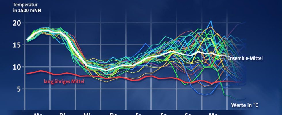
Our figure shows the time course of the temperature at about 1500 meters above sea level for Frankfurt am Main, starting on Monday. This is a so-called ensemble forecast. It is made up of a larger number of different model predictions (thin lines of different colors). With the help of such ensemble calculations, it is possible to estimate how robust the forecast is for a specific point in time. The closer the thin curves are to each other, the more reliable the forecast is. Naturally, they fan out and spread out the more the further into the future you look. The scatter of the predictions results from slightly changed simulated initial states of the atmosphere at the start of the model calculations. The thick white line shows the average of all forecasts, the thick red line shows the climatological mean temperature.
The temperature at 1500 meters has some advantages over the usual 2 meter temperature. Small regional structures, day/night fluctuations or the effects of wind and cloud cover on the temperature are noticeably lower at an altitude of 1500 meters. On the other hand, you are not too high up to be able to draw clear conclusions about the situation near the ground. Or to put it another way: cold or warm at the top usually also means cold or warm at the bottom. Above all, such representations give a better impression of supra-regional events.
From around 17°C (degrees Celsius) on Monday and Tuesday of this week, the temperature values shown decrease noticeably on Wednesday and average just under 10°C on Thursday. Despite the strong cooling, it is still too warm for the time of year, as a comparison with the long-term average shows.
Tuesday brings showers and thunderstorms, especially to the northwest half, while on Wednesday the focus of events moves to the southeast half of the country. Then it sometimes rains for a long time. There is a risk of local storms on both days.
For the rest of the week the influence of high pressure is already looming again and the temperature trend is pointing upwards. On the front side of a low approaching from Western Europe, very warm air could reach us again over the weekend. The exact development remains to be seen, not least because the individual temperature curves will then increasingly diversify.
Monday, September 11, 2023 (publication date)