News Weather
This Monday, September 11, the intense heat is gradually receding, but the atmosphere is quite tropical due to the humidity brought by the showers and storms.
To remember
– end of heat wave over 2/3 of the country in a heavy and stormy atmosphere
– the intense heat persists for another 24 hours in the east
– generalized stormy offensive during the night from Monday to Tuesday
Thermal indicator of the day (average temperature over 30 cities in France)
Minimum temperature: 18°C
Maximum temperature: 29.1°C
Average temperature: 23.6°C, or +5.2°C compared to seasonal norms
Evolution compared to yesterday
What changes compared to Sunday is the drop in temperatures in the west in an atmosphere that remains heavy. There is also a change in the sky in the central regions where clouds are increasing in a humid and tropical atmosphere. For the east of the country, this Monday is the last day of the heat wave.
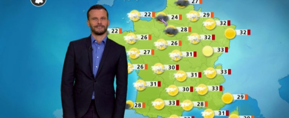
Details by region
Of the Normandy coasts And Breton to Pyrenees, you spend the day under a cloudy sky, with a few stormy showers. Although it is cooler than Sunday, the feeling nevertheless remains heavy.
Min temperature: 15 to 24°C
Max temperature: 25 to 33°C
Of the Hauts-de-France At Paris Basin to the center Regionthe heat wave ends, but the atmosphere is very heavy under a milky-looking sky, sometimes threatening, with a risk of thunderstorms which increases in the evening
Min temperature: 17 to 24°C
Max temperature: 28 to 33°C
In Occitanie, low clouds remain at the seaside, pushed by the sea wind. The Autan continues to blow across Midi-Toulouse, up to 60 km/h in gusts.
Min temperature: 17 to 23°C
Max temperature: 28 to 31°C
Everywhere else, that is to say over a large eastern half of the territory, you continue to be very hot. The south wind strengthens in the Rhône valley.
Min temperature: 17 to 23°C
Max temperature: 30 to 35°C
Further trend : Tuesday, the heat wave ends. Thunderstorms gain ground and reach most of the country and are sometimes strong and accompanied by hail. Temperatures are dropping, air quality is improving and we are breathing better!