News Weather
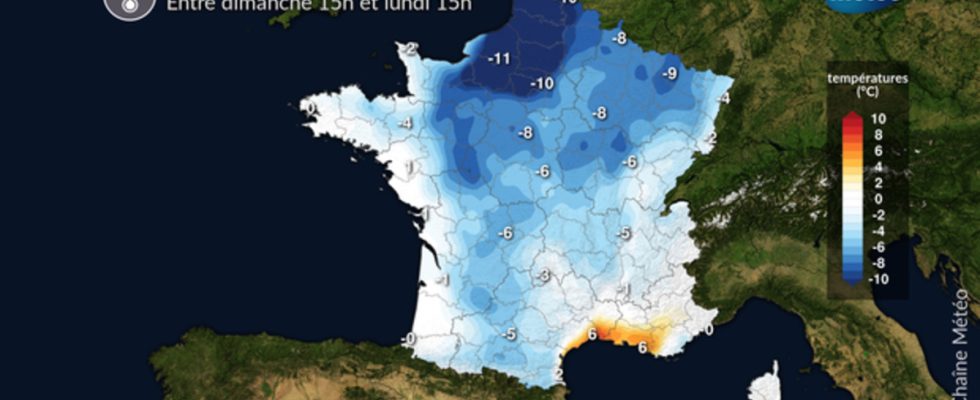
This Monday, June 26, the heat drops a notch compared to Sunday due to the lifting of a sometimes sensitive north-westerly wind which sometimes causes the temperature to drop by 10°C in 24 hours. On the sky side, there are a few more clouds than Sunday, without affecting the impression of good weather.
To remember
– drop in temperature compared to Sunday, except near the Mediterranean
– lifting of the mistral and the tramontane to the south-east increasing the risk of fires starting
– despite a few clouds, especially in the morning, the impression of good weather is largely maintained
Evolution compared to yesterday
What changes compared to yesterday is the drop in temperature over 3/4 of the country, except in the south-east where the mistral and the tramontane have a foehn effect and cause the temperature to rise between 37 and 39°C from Provence in Languedoc. The other difference comes from the color of the sky, with greyness this morning in the southwest and a sometimes thick cloudy veil circulating in the north of France.
Details by region
North of the Loire, your sky is cloudy, without altering the impression of good weather. The northwest wind blows around 40 km / h in gusts, which has the effect of lowering the temperature compared to Sunday with a maximum of 23 to 28°C in the afternoon, i.e. 5 to 10° C less than yesterday. We will breathe well!
Min T°: 13 / 18°C Max T°: 23 / 28°C
Of Aquitaine basin to Pyrenees, low clouds are numerous this morning. As the hours go by, they allow a few clearings to pass. The clouds remain clinging to the Pyrenees, with persistent fog at altitude and a risk of thunderstorms on the east of the chain.
Min T°: 13 / 18°C Max T°: 26 / 29°C
On the Mediterranean regions, mistral and tramontane rise and reach 60 km/h in gusts. They accentuate the heat. Due to the Foehn effect, temperatures reach 37 to 39°C in the afternoon, and locally 40°C in the Languedoc hinterland and the interior of the Var.
Min T°: 17 / 22°C Max T°: 36 / 39°C with peaks at 40°C
Everywhere else, the weather is nice with less heat compared to Sunday. A few cumulus develop in the afternoon over the northern Alps and the Jura, which can cause an isolated thunderstorm.
Min T°: 12 / 18°C from the Ardennes to Poitou Max T° around 30°C in the plain
Further development: Tuesday, it will be cool in the morning north of the Loire, with locally 7 to 9°C at daybreak in the countryside, while it will continue to be very hot in the Mediterranean regions in the afternoon with 35°C on average. On the sky side, inconsequential clouds will circulate in the sky of the northern regions, without altering the impression of fine summer weather without excess.