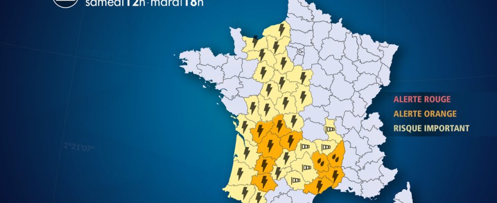
From Saturday April 27 at 12:00 to Tuesday April 30 at 6:00 p.m.
Complete live weather forecasts by telephone at
3201*
Situation
The weather situation will deteriorate very significantly this weekend with first of all a powerful storm wave in the west and the onset of a Mediterranean episode from Saturday to Tuesday evening. This Mediterranean episode, atypical for the season, lasting and intense, will be likely to cause significant flooding in the south of the Massif Central and in Languedoc-Roussillon. In this context, the Pyrénées-Orientales will finally be able to benefit from beneficial watering.
Here is the chronology of these bad weather:
– Saturday, violent thunderstorms, sometimes severe, will break out from Aquitaine to the Loire Valley and Normandy. This stormy wave will be violent but brief, ending in the evening.
– Saturday, southeasterly winds blow strongly in Languedoc and the south of the Massif-Central, as well as in the mountains with a storm at altitude and strong waves on the coast.
– Sunday, the improvement is clear in the west and the winds weaken in the southeast. But the rain-storm episode takes place over the long term on a not very mobile and stationary axis going from the Gulf of Lion to the Cévennes and going up to the center-east. These heavy rains will take on a marked stormy character over the Hérault. By the persistence of this rain until at least Tuesday evening in these same regions, the accumulations will become very abundant (exceeding 200 to 250 mm locally), we can now fear significant flooding in the Cévennes watersheds and in the south of the central massif. .
Observation
The episode hasn’t started yet.
Evolution
Chronology and characteristics of this degradation:
– SATURDAY : the stormy deterioration sets in in the afternoon, between the Pyrenees, Aquitaine, Limousin, and all of central-west France. The strongest storms break out between the Garonne and Limousin at the end of the afternoon, with hail and powerful wind gusts of up to 100 km/h. In the Loire Valley, rainfall amounts are expected to be significant. In the evening, these storms reach as far as Normandy, also affecting, to a lesser extent, Ile-de-France. The lull will be quite rapid after 10 p.m. Accumulated rain could reach 40 to 50 mm under the strongest storms, which could lead to heavy runoff and occasional flooding.
– At the same time, south-easterly winds are clearly strengthening between the Gulf of Lion, the south of the Massif Central and the Rhône valley (gusts between 80 and 100 km/h in plains and valleys, and 120 km/h in the mountains ).
– Saturday evening and night:
The storms are calming down, but still heavy showers persist in the central regions and Normandy.
To the south-east, the winds blow strongly around the Gulf of Lion and the Massif Central, as well as in the Rhône valley and the Pre-Alps (up to 100 km/h on the plains). At altitude, a Foehn storm is expected (gusts reaching 130 km/h).
– Sunday :
The weather becomes calm again in the west. To the south, the wind weakens significantly. But the rains will continue all day from the Gulf of Lion to the Cévennes and the center-east. They will be regular, with temporary intensifications, particularly in the morning, then at midday and especially at the end of the afternoon, when violent storms will break out in Hérault and Gard. Some of the largest accumulations are even expected on the Hérault plain, and not only in the mountains as is often the case. The risk of flooding will therefore be increasing both in areas of relief, but also in the plains under stationary storms (“V” storms, taking the shape of this letter on satellite images). risk seems to be Sunday evening.
Further trend:
The rainy episode will persist overnight from Sunday to Monday in the same regions, temporarily losing a little intensity.
List of departments concerned
- 07 – Ardeche
Precipitation – Orange Alert
Thunderstorms – Significant Risk
- 12 – Aveyron
Precipitation – Significant Risk
Wind – Significant Risk
- 14 – Calvados
Thunderstorms – Significant Risk
- 15 – Cantal
Wind – Significant Risk
- 16 – Charente
Thunderstorms – Orange Alert
- 17 – Charente Maritime
Thunderstorms – Significant Risk
- 18 – Dear
Thunderstorms – Significant Risk
- 19 – Corrèze
Thunderstorms – Orange Alert
- 23 – Dig
Thunderstorms – Significant Risk
- 24 – Dordogne
Thunderstorms – Orange Alert
- 27 – Eure
Thunderstorms – Significant Risk
- 28 – Eure-et-Loir
Thunderstorms – Significant Risk
- 30 – Gard
Precipitation – Significant Risk
Thunderstorms – Orange Alert
Submergence – Significant Risk
- 32 – Gers
Thunderstorms – Orange Alert
- 33 – Gironde
Thunderstorms – Significant Risk
- 34 – Hérault
Precipitation – Significant Risk
Thunderstorms – Orange Alert
Submergence – Significant Risk
- 36 – Indre
Thunderstorms – Significant Risk
- 37 – Indre-et-Loire
Thunderstorms – Significant Risk
- 40 – Landes
Thunderstorms – Significant Risk
- 41 – Loir-et-Cher
Thunderstorms – Significant Risk
- 42 – Loire
Wind – Significant Risk
- 43 – Haute-Loire
Wind – Significant Risk
- 45 – Loiret
Thunderstorms – Significant Risk
- 46 – Batch
Thunderstorms – Significant Risk
- 47 – Lot-et-Garonne
Thunderstorms – Orange Alert
- 48 – Lozere
Precipitation – Orange Alert
Thunderstorms – Significant Risk
Wind – Significant Risk
- 61 – Orne
Thunderstorms – Significant Risk
- 64 – Pyrénées-Atlantiques
Thunderstorms – Significant Risk
- 65 – Hautes-Pyrénées
Thunderstorms – Significant Risk
- 72 – Sarthe
Thunderstorms – Significant Risk
- 76 – Seine-Maritime
Thunderstorms – Significant Risk
- 79 – Two Sevres
Thunderstorms – Significant Risk
- 81 -Tarn
Wind – Significant Risk
- 82 – Tarn-et-Garonne
Thunderstorms – Significant Risk
- 86 – Vienna
Thunderstorms – Significant Risk
- 87 – Haute-Vienne
Thunderstorms – Orange Alert