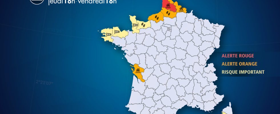
From Thursday November 9 at 6:00 p.m. to Friday November 10 at 6:00 p.m.
Complete live weather forecasts by telephone at
3201*
Situation
Due to further heavy rainfall in progress until Friday, Pas-de-Calais has returned to red level alert for the Liane and Aa rivers.
According to the Vigicrues organization, the floods of the Liane and the Aa were exceptional, exceeding historic flood levels (March 2002 in particular) with numerous damaging overflows affecting around sixty municipalities. The decline which began between Tuesday and Wednesday was short-lived due to the return of rain and showers from Wednesday evening. As a result, rivers are in flood again with a new red alert in effect.
Until Friday, the weather is very unsettled and unstable with a succession of lines of heavy rain or showers. This precipitation locally takes on a stormy character with intensities of around ten millimeters in an hour. Over the entire episode, until Friday evening, cumulative rainfall could reach 70 to 90 mm and locally more than 100 mm in the areas most exposed to heavy precipitation, notably the hills of Artois.
Seine-Maritime and the Bay of Somme and to a lesser extent the Nord department are also affected by episodes of heavy rain with 30 to 60 mm between now and Friday evening, locally 80 mm on the Alabaster Coast.
In Charente-Maritime, total rainfall reaches 15 to 30 millimeters, locally 40 mm. These rains lead to moderate flooding and some flooding.
Finally, Corsica is experiencing heavy stormy rains with cumulative rainfall of 40 to 50 mm on average, but locally up to 80-90 mm with floods and some river overflows to be expected.
Observation
This Thursday
At 6:00 p.m., showers followed one another in Hauts-France and in particular Pas-de-Calais. The gale was in place in Brittany and on the Cotentin with a gust measured at 110 km/h at Belle-Île en-mer (Morbihan), 102 km/h at Ouessant (Finistère) and 90 km/h at Carteret ( Sleeve).
At 3:00 p.m., over the last 6 hours, we recorded 17.1 mm in Boulogne (Pas-de-Calais) and 9.6 mm in Cap Gris-Nez (Pas-de-Calais). Sustained showers are now taking over. The wind is blowing strongly in Brittany with gusts up to 80-90 km/h on the Breton and Cotentin coasts. We recorded up to 101 km/h at Pointe du Raz (Finistère)
At 9:00 a.m., a line of showers circulates between the Côte d’Opale and the hills of Boulonnais, giving 1 to 3 mm in a short time. It circulates quite quickly and will be followed by a more intense and widespread rainy deterioration in the second part of the morning and afternoon. The weather remains dry between Seine-Maritime and the Somme but heavy rain will arrive at midday. The wind increases significantly between Brittany and Cotentin with 103 km/h on the island of Groix (56), 96 km/h at the tip of Penmarc’h (29), 87 km/h at Brignogan (29) and 81 km/h at Carterets (50).
At 7:00 a.m., a temporary lull occurs after the rains of recent hours. Between 20 and 25 mm fell over the last 24 hours between the Côte d’Opale and the hills of Artois, which corresponds to a week of precipitation. We noted 20.6 mm in Radinghem, 21.4 mm in Boulogne-sur-mer, 22.3 mm in Attin and 24 mm in Le Touquet. The Liane in Isques reacts after this new rain with a level of 4.08 m, approaching the 2015 flood (4.39 m). The Aa in Wizernes reacts more moderately with a water level of 1m62, still far from the flood peak of November 7 of 2m41.
In Seine-Maritime we recorded 15 mm in Goderville, 17 mm in Saint-Romain-de-Colbosc and 19 mm in Saint-Martin-du-Bec. The wind blows between 70 and 80 km/h on the Breton tip.
Evolution
Friday, new heavy rains or showers accompanied by violent gusts of wind are sweeping the Channel coasts, Normandy and Hauts-de-France. The showers locally take on a stormy character and will give an additional 20 to 40 mm in the Pas-de-Calais department most affected by the floods and floods. Over the entire episode (until Friday), cumulative rainfall will reach 70 to 80 mm and locally more than 100 mm on the hills of Boulonnais and Artois. Serious flooding and river overflows are in the news. Strong gusts occur on the Breton coasts and in Cotentin with peaks of 100 km/h. The critical period extends between 10 a.m. and 3 p.m., when an active and stormy front passes. In Corsica, another stormy spell is expected at the end of the morning with heavy rain activity and accumulations of an additional 30 to 40 mm.
SATURDAY, an improvement is expected with the swelling of a dorsal, but the respite will be short-lived. As soon as the flood has subsided, more rain is expected from Sunday in these same regions.
List of departments concerned
- 14 – Calvados
Precipitation – Significant Risk
- 17 – Charente Maritime
Floods – Orange Alert
- 2A – South Corsica
Precipitation – Significant Risk
Thunderstorms – Significant Risk
- 22 – Côtes-d’Armor
Wind – Significant Risk
- 29 – Finistère
Wind – Significant Risk
- 50 – Sleeve
Wind – Significant Risk
- 59 – North
Precipitation – Significant Risk
Floods – Orange Alert
- 62 – Pas-de-Calais
Precipitation – Orange Alert
Floods – Red Alert
- 76 – Seine-Maritime
Precipitation – Orange Alert
- 80 – Sum
Precipitation – Orange Alert
Flooding – Significant Risk

