From Saturday March 30 at 6:00 p.m. to Monday April 1 at 12:00 a.m.
Complete live weather forecasts by telephone at
3201*
Situation
For more than a month, the south-east of France has suffered a succession of Mediterranean and Cévennes episodes. This is the case again this weekend, between this Saturday evening and the night of Sunday to Monday. This Mediterranean and Cévennes episode is the sixth since the beginning of February, which has never happened at this time of the year. The context is always the same: in the middle of a vast low pressure system extending from the Atlantic to the Mediterranean, small depressions circulate from the Balearic Islands to Corsica. They bring up unstable air saturated with humidity which causes intense rain between Languedoc, the Cévennes and Provence-Alpes Côte d’Azur. In the mountains, snow replaces rain above 1300 meters. These bad weather conditions are accompanied by very strong winds in the mountains and rough seas, which can lead to the risk of submersion.
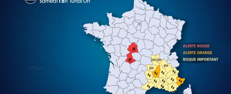
Furthermore, due to the heavy rain that fell during the night from Friday to Saturday, Vienne and Creuse are experiencing major flooding. VIGICRUE has passed the RED level (maximum level) in the departments of Indre-et-Loire and Vienne. Even if the precipitation weakens in the coming days, occurring in the form of showers, the decline should be slow.
Observation
This Saturday
At 6 p.m., heavy stormy showers move up along the Rhône towards the Saône Valley. Other stormy showers are circulating from the Côte d’Azur to the south of the Alps. During these showers, intensities can reach 5 to 10 mm/h. This is the case in Valencia where between 3 and 4 p.m. 9 mm of water fell.
At 15h, after a calm at the beginning of the afternoon, the instability strengthens very quickly. Stormy showers are increasing between Ardèche and Drôme where electrical activity is particularly strong.
At 12, heavy rains move up from the Cévennes towards the Rhône valley and the Lyon region. In the Isère Pre-Alps and the Vercors as well as between Saint-Etienne and Lyon, the wind has weakened compared to the night, but this calm is only temporary.
At 9 a.m., heavy rains come from the Mediterranean towards the Cévennes. These precipitations occasionally take on a stormy character. The wind blows strongly at 90 km/h between the Cévennes, the Lyon region and the Vercors.
Evolution
Between this evening and the middle of the night from Saturday to Sunday, a lull is emerging. But it is only temporary.
Sunday morning, a new episode of intense rains comes up from the Mediterranean and reaches the entire south-east, from Languedoc and the Cévennes to PACA. The wind blows violently between Le Puy, Saint-Etienne, Lyon and the center of Isère with gusts reaching 90 km/h.
Sunday afternoon, a temporary lull takes place.
From Sunday evening until the middle of the night from Sunday to Monday, a burst of heavy rain is sweeping the entire east of the country, and in particular the Mediterranean and Cévennes regions, once again affected by intense stormy rains. This will be the most critical moment of this episode of bad weather: through accumulation, this precipitation will lead to significant risks of flooding and intense urban runoff. In the mountains, it will snow heavily in the south of the Alps.
Monday morning, the disturbance will linger east of the Rhône and the Saône until around 9 a.m., bringing still quite marked rain, before a rapid improvement.
List of departments concerned
- 04 – Alpes de Haute Provence
Precipitation – Significant Risk
- 05 – High mountains
Precipitation – Significant Risk
- 06 – Alpes-Maritimes
Precipitation – Orange Alert
- 07 – Ardeche
Precipitation – Orange Alert
- 13 – Bouches-du-Rhône
Precipitation – Significant Risk
- 26 – Drôme
Precipitation – Significant Risk
- 30 – Gard
Precipitation – Significant Risk
- 34 – Hérault
Precipitation – Significant Risk
- 36 – Indre
Floods – Red Alert
- 38 – Isère
Wind – Significant Risk
- 42 – Loire
Wind – Significant Risk
- 43 – Haute-Loire
Wind – Significant Risk
- 48 – Lozere
Precipitation – Significant Risk
- 69 – Rhone
Wind – Significant Risk
- 83 -Var
Precipitation – Significant Risk
- 84 – Vaucluse
Precipitation – Significant Risk
- 87 – Haute-Vienne
Floods – Red Alert