From Friday March 8 at 12:00 to Sunday March 10 at 12:00.
Complete live weather forecasts by telephone at
3201*
Situation
A deep depression is deepening over the Bay of Biscay this weekend, generating a strong southerly current disturbed in the south-eastern quarter. Heavy rains are blocking the Cévennes massif, generating very significant rainfall accumulations, up to 250 mm. The southerly wind is also building up along the Rhône valley and into the Loire with gusts exceeding 100 to 110 km/h this Saturday.
More rain will return to the PACA region at the end of the day on Saturday with also high accumulations expected, up to 150 to 200 mm between the Var and the Maritime Alps. Snow falls in abundance above 1300 m in the south of the Alps.
On Sunday, the agitation will quickly evacuate towards Italy.
Observation
This Friday
At 2 p.m., conditions are very degraded on the coast with a lot of instability. We recorded 106 km/h in Aigues-Mortes (30) and 102 km/h in Montpellier (34).
At 12, the rains continue to rise through the Gulf of Lion with intensities reaching 12 to 15 mm/h. These rains reach the Cévennes relief with the snow which begins to fall on the summits, above 1300 m. The rain-storm bursts also concern the Bouches-du-Rhône with high intensities noted in Marseille (13).
At 8 o’clock, the black autan wind blows strongly in its area, with gusts that exceed 100 km/h on the reliefs of the Tarn. We find 109 km/h in Sorèze (338 m) and 105 km/h in Dourgne (234 m).
Rains are returning to Languedoc-Roussillon with intensities of 6 to 9 mm/h. These rains have not yet reached the Cévennes.
Evolution
This afternoon :
Heavy rain and strong winds persist between the Gulf of Lion and the southern heights of the central massif. Snow falls heavily from 1200 m on the terrain. Lozère is particularly concerned. With the wind blowing strongly, snowdrifts can form with difficult traffic conditions on secondary networks.
Tonight and next night:
Precipitation persists in the Cévennes, but is of less intensity. A lull occurs on the Languedoc plain with the return of dry weather and significantly less wind. The Autan wind will have calmed down on the Tarn and Aveyron. The south-east wind strengthens, on the other hand, over the Cévennes, the south of the Massif Central, up to the Pilat massif with peaks between 80 and 90 km/h.
Saturday morning :
The rains are getting stronger again in the Cévennes while the weather still remains calm in the PACA region. It is especially from 9 a.m. that the precipitation intensifies from the north of Hérault to the Ardèche Cévennes with maximum intensities of 15 to 20 mm/h. It snows on the peaks of Lozère from 1200 meters. The south-southeast wind is strengthening again over the center-east and the Rhône valley with peaks of 100 km/h on the terrain. Be careful, in coastal areas, strong waves (3-4 meters) are likely to cause marine submersion.
Saturday afternoon :
The rains intensify and spread from the north of Hérault to Haute-Loire with maximum intensities of 25 mm/h. It snows heavily on Aubrac from 1200 meters. The rains spread at the end of the afternoon, towards Provence and the Côte d’Azur with maximum intensities of 10 to 15 mm/h. The critical period begins with gusts of up to 100-110 km/h in the east of Haute-Loire and with surges in the Gier valley and the Saint-Etienne basin.
Saturday evening and following night:
The heavy rains continue in the Cévennes until around midnight then they only concern the PACA region in the second part of the night with heavy snowfall in the southern Alps and an avalanche risk becoming strong. The southerly wind weakens quickly on the Massif Central, while it remains strong on the coast with strong waves of 3 to 4 meters.
Sunday morning
The improvement will be rapid with the evacuation towards the east of the depression responsible for the bad weather. However, the risk of avalanches will remain high in the southern Alps.
Over the entire episode, we expect:
– cumulative rainfall of 150 to 250 mm, with peaks of 300 mm very locally on the Cévennes peaks, which is equivalent to 1 to 2 months of precipitation
– snow depths of 60 to 80 cm in the southern Alps, locally 1 meter with a high risk of avalanche
– maximum gusts of 100-110 km/h, locally 120 km/h due to surging effect in the valley
– a strong swell of 3 to 4 m around the Gulf of Lion and especially on the coasts of the Camargue
– a risk of waterspout on the coast
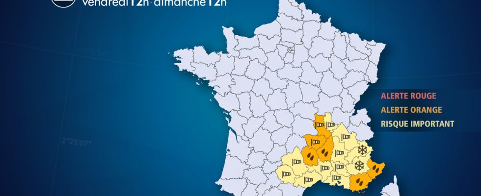
List of departments concerned
- 04 – Alpes de Haute Provence
Snow – Significant Risk
Avalanche – Significant Risk
- 05 – High mountains
Snow – Significant Risk
Avalanche – Significant Risk
- 06 – Alpes-Maritimes
Precipitation – Orange Alert
- 07 – Ardeche
Precipitation – Orange Alert
Wind – Significant Risk
- 12 – Aveyron
Precipitation – Significant Risk
Wind – Significant Risk
- 13 – Bouches-du-Rhône
Wind – Significant Risk
Submergence – Significant Risk
- 26 – Drôme
Wind – Significant Risk
- 30 – Gard
Precipitation – Significant Risk
Wind – Significant Risk
Submergence – Significant Risk
- 34 – Hérault
Precipitation – Significant Risk
Wind – Significant Risk
Submergence – Significant Risk
- 38 – Isère
Wind – Significant Risk
- 42 – Loire
Wind – Orange Alert
- 43 – Haute-Loire
Wind – Orange Alert
Snow – Significant Risk
- 48 – Lozere
Precipitation – Orange Alert
Wind – Significant Risk
Snow – Significant Risk
- 69 – Rhone
Wind – Significant Risk
- 81 -Tarn
Precipitation – Significant Risk
Wind – Significant Risk
- 83 -Var
Precipitation – Orange Alert
- 84 – Vaucluse
Wind – Significant Risk