From to
Situation
A very disturbed flow from the southwest sector circulates from the near Atlantic towards the British Isles, called “atmospheric river”. In this flow, the winds are blowing steadily, causing a typical gale for this time of year.
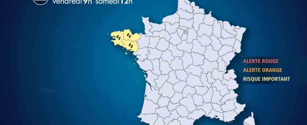
On the other hand, the parade of disturbances will lead to regular and abundant rains in Brittany. The soils being already saturated following the rains of this month of December, the additional accumulations could generate moderate reactions of the rivers descending from the Monts d’Arrée and the Montagnes Noires.
The interior of Finistère and Morbihan are the most exposed to abundant accumulations. The tidal coefficients, falling towards 50, are low and will facilitate the flow of river water to the sea, but the strong waves can still hinder this flow during high seas.
This month of December is already rainier than average in Brittany, especially in Brest. But we will remain far from the rainfall records of December 2020 or even December 1965.
Observation
At 10.30 a.m., the rains had subsided. The accumulations were between 15 and 25 mm in Brittany, with 26 to 30 mm on the Arrée mountains (Finistère). The southwest wind was blowing strongly at times. Thus, we recorded up to 118 and km / h at the tip of the Roc (Granville, Manche), 115 km / h at the tip of Penmarch (Finistère), 114 km / h at Ouessant. Inland, gusts between 80 and 90 km / h were recorded in Lower Normandy and Brittany (91 km / h in Brest).
This Friday morning, ppouring rain and high winds affected Brittany with gusts between 75 and 80 km/h generalized, locally 100 km/h on exposed capes. The accumulations of rain linked to the disturbance which arrived this night gave accumulations of 11 to 15 mm generalized with 26 mm in the Arrée mountains. The small streams descending on southern Brittany had a weak reaction (30 cm rise in Quimper since yesterday).
Yesterday Thursday marked a lull before the arrival of the strong disturbance at the end of the night, this Friday, from around 4 a.m. by Finistère.
The accumulations of the previous night had remained moderate, with 5 to 10 mm in the plain and on the littoral zone, but around 18 mm on the reliefs of Finistère and Morbihan.
Evolution
During this episode, we expect:
– additional accumulations of rain of 50 to 80 mm by Saturday afternoon in the interior of Finistère and Morbihan, with possible peaks of 100 mm on the reliefs.
– strong winds reaching 80 to 90 km/h, with gusts between 100 and 110 km/h on exposed headings.
– very rough seas with waves of 5 to 8 m, but with low tidal coefficients, which will limit coastal flooding.

