
Hurricane Ian is rapidly gaining strength. The hurricane is heading towards Florida with wind gusts of around 250 km/h. The news ticker.
- Catastrophic storm surges, winch and floods: Hurricane “Ian” now reaches wind speeds of up to 250 km/h
- Hurricane Alert in Florida: TV presenter warns drastically – “You can’t survive that”
- Hurricane Ian continues to move on course Florida
- This News Ticker for Hurricane “Ian” becomes regularly updated.
Update from September 28, 3:24 p.m.: The National Hurricane Center is forecasting life-threatening storm surges of almost 5.5 meters for some parts of southwest Florida. The authorities are already assuming high water levels and severe flooding. Record levels are forecast for at least five places in Florida, with the level rising to over seven meters.
Meanwhile, Florida residents continue to be warned – because the time to evacuate is becoming increasingly scarce. Jamie Carson, communications director for Sarasota County, Fla., told residents that this is “the last opportunity to get to the evacuation centers” at this time. Otherwise, people “must be prepared to take shelter on the ground.”
Hurricane “Ian” now reaches wind speeds of up to 250 km/h
Update from September 28, 1:13 p.m: “Ian is strengthening fast” – according to the latest data from the National Hurricane Center, the wind speed is now 250 km/h. Hurricane “Ian” thus almost reaches category 5 on the Saffir-Simpson hurricane wind scale.
“Hurricane Ian could cause catastrophic storm surges, winds and flooding in the Florida peninsula,” the National Hurricane Center said. The hurricane will make landfall during Wednesday afternoon.
- Hurricane Category 4 (Very Strong): wind 209 to 251 km/h; Rise in water level 3.8 to 5.4 meters.
- Category 5 hurricane (devastating): wind > 251 km/h; Rise of the water level over 5.5 meters.
“It’s a big, big storm. There will be major damage, including to the infrastructure. The power will also go out,” said Florida Governor Ron DeSantis at a press conference. He warned residents to heed local authorities’ warnings and not go outside until the storm has passed.
Hurricane alert in Florida: TV presenter warns drastically – “You can’t survive that”
Update from September 28, 10:41 am: Hurricane Ian moves relentlessly toward Florida’s coast. Florida Governor Ron DeSantis urges the population in risk areas to get to safety as a matter of urgency. “This is their last chance.” At first it is unclear exactly how the hurricane’s track is going. No one should take the current situation lightly. A moderator at Fox News broadcaster makes this clear with drastic words. He makes an absolutely grim prognosis.
“See that? Melbourne, Daytona Beach all the way to Jacksonville,” a Fox News presenter explains a chart forecasting the hurricane’s path. But what if the hurricane moved 20 miles west, he asks viewers. He provides the answer right away: “All of you are dead. You can’t survive that. It is not possible. Unless they’re just very, very lucky. And your children will die too.”
With the comment “most intensive weather transmission of all time” a user shares this gloomy forecast on Twitter. The clip has since been clicked on more than 6.8 million times.
Hurricane Ian: 2.5 million people have to evacuate their homes
Update from September 28, 9:25 am: “This is a life-threatening situation,” says the US weather service NOAA. Hurricane Ian is the first major hurricane to hit the west coast of Florida this year. Its track has recently shifted slightly to the east again, moving further away from Tampa Bay and approaching Cape Coral, a less densely populated area.
2.5 million people have fled their homes in high-risk coastal areas, the reports Miami Herald. The wind pushes water masses against the coast. Storm surges of up to four meters high are therefore to be expected. Heavy rainfall – sometimes 600 liters of rain per square meter – could be in parts of Florida. The US Weather Service has also issued a tornado warning. Two tornadoes have wreaked havoc at a North Perry airport. Several small aircraft are damaged. Miami International Airport will remain open until further notice. The hurricane is already making itself felt with heavy rainfall and strong gusts of wind.
Hurricane Ian continues on course for Florida
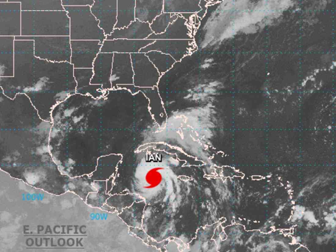
Update from September 28, 6:19 am: Hurricane “Ian” is currently over the Gulf of Mexico, said the US weather service. The hurricane continues to head for Florida, as can be seen on current satellite images.
“Ian” will cause a life-threatening storm surge, catastrophic winds and flooding across the Florida Peninsula, authorities warn on Twitter. A storm surge warning has been issued for the Lower Florida Keys. Experts believe Ian will make landfall as a Category 3 or 4 hurricane.
| Tropical low | from 62 km/h |
| tropical storm | 63 – 118 km/h |
| Category 1 hurricane | 119 – 153 km/h |
| Category 2 hurricane | 154 – 177km/h |
| Category 3 hurricane | 178 – 208km/h |
| Category 4 hurricane | 209 – 251km/h |
| Category 5 hurricane | from 252 km/h |
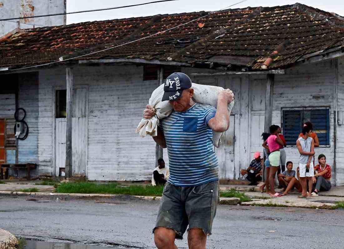
All of Cuba in the Dark – Power Outage After Hurricane “Ian”
Update from September 28, 6:05 am: Hurricane Ian has caused a nationwide power outage in Cuba. Cuba’s power grid is considered ailing and the infrastructure is outdated. Restoring the power supply is a complicated process that will take place gradually during the night and in the morning. In the capital, Havana, lights could only be seen in the few buildings that had generators — mostly hotels. Parts of the country, including the capital, were without power for most of Tuesday.
Update from September 27, 5:12 p.m.: The dangerous hurricane “Ian” has reached Cuba and caused flooding and damage there. With sustained wind speeds of up to 205 kilometers per hour, the hurricane hit land near the town of La Coloma in the west of the Caribbean island early Tuesday, according to the US Hurricane Center (NHC). After Cuba, the storm center was expected in the nearby US state of Florida.
Social media users reported a terrifying night from the hard-hit areas of western Cuba. A video showed a house flooded during heavy rain because the roof was missing. Flooded streets and fallen trees were seen in several locations in pictures.
Communication with the people affected was restricted, according to reports on state television, internet access and telephone connections failed in some places. It appealed to the solidarity that Cubans are known for. The storm also made itself felt in the capital, Havana, with rain and strong winds. In view of the general lack of many products and basic necessities, the residents were only able to make makeshift preparations. In addition, many houses in Cuba are in a state of disrepair and were therefore ill-equipped for a storm.
Hurricane Ian makes landfall in western Cuba
Update from September 27, 10:55 am: Hurricane Ian made landfall in western Cuba with wind gusts of around 205 km/h.
Hurricane “Ian” hits Cuba: Peak gusts of around 205 km/h – Florida evacuates 300,000 people
Florida, meanwhile, has issued an evacuation order for Tampa residents. 300,000 people are affected. Authorities warn that other regions and cities will follow in the next few days. The situation could quickly deteriorate. Hurricane Ian has been gaining strength in the past few hours. Ian could develop into a Category 4 hurricane over the warm waters of the Gulf of Mexico.
Hurricane Ian upgraded to Category 3
Update from September 27, 7:51 a.m: Hurricane Ian is making landfall in Cuba soon, the U.S. Weather Bureau’s National Hurricane Center tweeted Tuesday morning. According to current data, the weather experts now estimate the wind speed at 185 km/h – sometimes even higher. This makes Ian a Category 3 hurricane.
Hurricane “Ian” now a Category 3 on the Saffir-Simpson Hurricane Scale since 2012
Update from September 27, 7:34 a.m: Hurricane Ian is gaining strength and heading for Cuba and the US state of Florida. The hurricane was a Category 2 out of 5, according to the US Hurricane Center.
“Life-threatening storm surges, hurricanes, flash floods and possible landslides” are expected in Cuba. According to the latest information from the Cuban weather authorities, wind speeds of 111 km/h have already been measured on Isla de la Juventud.
The hurricane may then move further towards the west coast of Florida with a magnitude of 4. Meteorologists there warn of storm surges from Wednesday – the risk is greatest between the cities of Fort Myers and Tampa.
Tropical storm “Ian” develops into a hurricane: Cyclone heads for Florida – state of emergency declared
First report from September 26, 2022
Miami – The US state of Florida is already declaring a state of emergency. Tropical Cyclone Ian is heading for the coast. The tropical storm continues to increase in strength. “Ian” is expected to become a on Monday hurricane and continue to gain strength as a result, the US Hurricane Center (NHC) announced on Monday.
Hurricane “Ian”: This course is taken by the tropical storm
Weather officials are watching “Ian” very closely. It’s the fourth hurricane of the season. The tropical storm will first hit parts of Cuba and Jamaica. previously had Tropical Storm Fiona wreaked havoc in the Caribbean.
“Ian” is moving at a speed of 22 kilometers per hour, according to INSMET. According to the Cuban weather authorities, the tropical storm will reach wind speeds of up to 120 km/h. The storm center west of the Cayman Islands is therefore heading for the island.
The hurricane will hit the Florida coast in the middle of the week, the NHC said in a recent forecast. That also takes care of the Moon mission “Artemis” for more problems.
US Hurricane Center warns of extreme storm surges
Strong winds and heavy rain are to be expected, especially in the western part of Cuba. The water level there could rise up to four meters above normal. The area around the capital Havana was also affected by tropical storm conditions. The expected large amounts of rain could cause flash floods and mudslides in higher areas of Cuba as well as Jamaica.
Hurricane Ian: US President postpones trip to Florida
with heavy RainAccording to the information, flash floods and floods are also to be expected in Florida by the middle of the week, first in the Florida Keys island chain and then further north. The governor of the southeastern US state, Ron DeSantis, declared a state of emergency as a precaution and called on the population to take precautions. US President Joe Biden, who wanted to travel to Florida for a campaign event on Tuesday, postponed the trip because of the storm. (ml/dpa)