Status: 02/17/2022 05:33 a.m
Two storm lows are moving across Germany from the west. Schools are closing in many regions, and there is a storm surge warning on the North Sea coast. In some places, sandbags are supposed to protect against the impending flood.
Fallen trees, loose roof tiles, canceled flights and delayed trains: Storm depression “Ylenia” initially hit the north and east of Germany in particular. The fire brigades and police control centers reported numerous operations in the early morning, but there was no major damage for the time being.
The German Weather Service in Offenbach had previously issued severe weather warnings for Wednesday evening to Thursday evening, mainly for the northern half of the country.
Sebastian Duden, NDR, with impressions of the storm “Ylenia”
daily topics 10:30 p.m., 16.2.2022
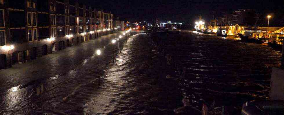
Storm surge in Schleswig-Holstein
Some of the flood levels on the North Sea coast of Lower Saxony were lower than expected. Unlike for Schleswig-Holstein and Hamburg, the Federal Maritime and Hydrographic Agency (BSH) had not warned of a storm surge here either. However, water levels about 1 meter higher than mean high water (MHW) were expected. According to a BSH spokesman, the water levels on Borkum were about 84 centimeters above the mean high water level. On Norderney, the water rose to 1.01 meters above sea level. Values of 1.15 meters were reached in Emden and 1.09 in Wilhelmshaven.
In Schleswig-Holstein, on the other hand, there was a storm surge. In Husum, at the Eidersperre and in Büsum, for example, the early morning high water values were more than 1.5 meters above the mean high water level. Exact figures were not initially available. In the Hamburg Elbe area, the flood should reach values that are 1.5 to 2 meters higher than the average flood. There is a risk of storm surges here until about 5:00 a.m. in the morning. Then the highest water level in Hamburg is expected. Then the fish market in Altona should be partly flooded again – like a few times earlier this year.
State of emergency in Berlin
The Berlin fire brigade declared a state of emergency early Thursday morning due to the storm “Ylenia”. Since 2 a.m. there has been a sharp increase in weather-related operations. Several volunteer fire brigades were called into service to support the professional fire brigade. In Lichterfelde, for example, three trees fell on several parked cars and a light pole was also carried away. There were initially no reports of injuries from Berlin.
A corona test station in Kleve on the Lower Rhine could not withstand the storm in the evening. The wind destroyed the tent of the drive-in test center in North Rhine-Westphalia, according to the fire brigade. According to firefighters, no one was injured.
Rail and air traffic affected
The storm also affected rail and air traffic. Fallen trees hampered trains. The extent was initially limited during the night. A tree fell on the tracks near Buchholz between Bremen and Hamburg. An ICE therefore had to be diverted, as a railway spokesman said. According to the company, trees in North Rhine-Westphalia blocked isolated side routes in the Dortmund area. The Dortmund-Münster connection was temporarily affected. Deutsche Bahn advised to find out about delays or train cancellations.
As a precaution, Lufthansa canceled 20 flights, as the company announced during the night on request. Travelers were advised to check the airline’s website for the status of their flight. According to the operator, connections to Berlin, Hamburg and Munich are affected at the largest German airport in Frankfurt.
Gusts of up to 152 km/h on the Brocken
According to the German Weather Service, average wind speeds of 120 kilometers per hour were measured between 12:30 a.m. and 1:00 a.m. on the exposed Brocken in the Harz Mountains. The peak wind during this period was 152 kilometers per hour. In other parts of Germany, too, there were hurricane gusts and hurricane-like gusts in exposed locations such as mountain peaks: In the above-mentioned period, wind speeds of an average of 87 km/h were measured on the Feldberg in the Black Forest, with peaks of 125 km/h. There were heavy gusts of wind, for example, at Cape Arkona on Rügen (77 km/h, 105 km/h peak) and at the Kiel lighthouse (79 km/h, 101 km/h peak).
In North Rhine-Westphalia, state school minister Yvonne Gebauer (FDP) canceled classes for Thursday. In several regions of Lower Saxony or Bavaria, for example, schoolchildren are allowed to stay at home on Thursday because of the weather hazards.
The next hurricane low is already waiting for Friday
According to the DWD, the wind from low “Ylenia” will slowly decrease from Thursday afternoon. However, the breather should only be brief. The next hurricane – called “Zeynep” – is expected to come from the British Isles as early as Friday afternoon. According to the DWD, the northern half in particular will probably be affected again.
Karsten Schwanke, meteorologist, with information about the severe storm low over Germany
tagesschau24 9:45 p.m., 16.2.2022