storm
Warning of squalls: These maps show where the wind is strongest today
Severe weather: The map shows where the fastest gusts of the day are expected. A current version can be found at the bottom of the article
© wetter.de

It will be stormy on Wednesday, especially in northern Germany. Maps give an impression of the weather situation and show where the wind is strongest.
Wind follows winter: According to the German Weather Service (DWD), a storm is moving east across the Arctic Ocean and will cause a stiff breeze throughout the country on Wednesday. In the north and west, severe squalls can be expected temporarily, and on the coasts and at higher altitudes, hurricane-like gusts can be expected, according to the DWD warning situation report on Wednesday morning. The storm peaks in the morning on the North Sea and in the afternoon and evening on the Baltic Sea. In the south and southwest of Germany the wind is somewhat weaker, with mainly stiff gusts. The wind decreases at night.
The maps below provide an overview of the weather situation:
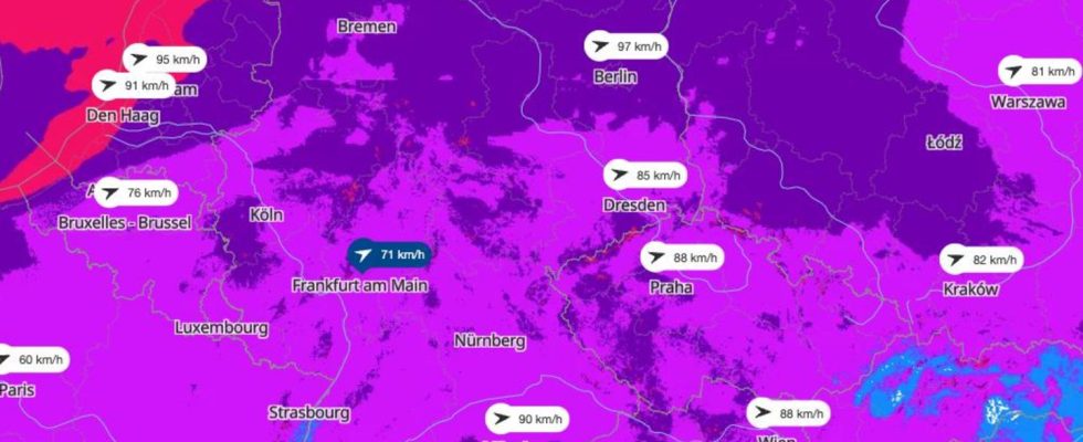
Map I: Where wind speeds are highest
The map above shows the wind speeds in Germany. The view is provided by the portal wetter.de, which, like stern, belongs to RTL Deutschland. Clicking on the map leads to wetter.de.
Map II: Storm warnings for today
The map above shows the thunderstorm warnings for today according to DWD. The view is also provided by the wetter.de portal.
Map III: See live where squalls are currently occurring
The interactive map below shows where gusts are currently occurring. You can also view the forecast for a later date using the timeline at the bottom of the graphic. At the top right, the level displayed can be changed to, for example, thunderstorms.
The service is provided by Windy.com. The makers use the model from the “European Center for Medium-Range Weather Forecasts” for their representations and forecasts.
Sources:DWD

Climate change
What the weather was like in Germany 50 years ago – and what it will be like in 2070
In the gallery: Was the weather in the 1970s like it is today? No. Even if some people feel otherwise: the data is crucial. And they also point to the future.