storm
Warning of squalls: These maps show where the wind is strongest today
The DWD has issued a warning for squalls. The maps in the article show where the strongest gusts occur
© wetter.de
In the north, the weather will be rough on Friday: there is a warning of squalls, and there is also a risk of a storm surge on the Baltic Sea coast.
The German Weather Service (DWD) warned on Friday of hurricane-like gusts on the Schleswig-Holstein Baltic Sea coast. These could reach wind speeds of up to 110 kilometers per hour, according to the warning situation report on the DWD website. As can be seen from the associated map with regional locations, the warning applies from Friday at 12:00 p.m. to Saturday at 2:00 a.m. At the same time, there is a storm surge warning for the Baltic Sea coast. You can find more information about flooding here.

The maps below provide an overview of the weather situation:
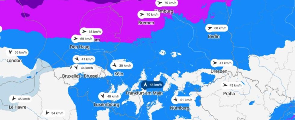
Map I: Where wind speeds are highest
The map above shows the wind speeds in Germany. The view is provided by the portal wetter.de, which, like stern, belongs to RTL Deutschland. Clicking on the map leads to wetter.de.
Map II: Storm warnings for today
The map above shows the thunderstorm warnings for today according to DWD. The view is also provided by the wetter.de portal.
Map III: See live where squalls are currently occurring
The interactive map below shows where gusts are currently occurring. You can also view the forecast for a later date using the timeline at the bottom of the graphic. At the top right, the level displayed can be changed to, for example, thunderstorms.
The service is provided by Windy.com. The makers use the model from the “European Center for Medium-Range Weather Forecasts” for their representations and forecasts.
Sources:DWDwith DPA
Climate change
What the weather was like in Germany 50 years ago – and what it will be like in 2070
In the gallery: Was the weather in the 1970s like it is today? No. Even if some people feel otherwise: the data is crucial. And they also point to the future.