Archaeological discoveries were not what the United States had in mind when it used spy satellites to take aerial photos of the Middle East in the 1960s and 1970s. But now these recordings are shaking up supposed certainties about the history of the Romans in the Middle East. Researchers have discovered 396 previously unknown Roman camps in what is now Syria, where the Roman Empire once met neighboring areas in the east. Until now it was considered likely that the fortifications there had served as a defensive wall against enemies. But the newly discovered structures lead their discoverers Jesse Casana, David Goodman and Carolin Ferwerda from Dartmouth College in Hanover, USA, to conclude that this wall was not as impermeable as thought. The fortresses therefore served more for trade and securing traffic routes in all directions.
The Romans first expanded into the region in the early second century AD. Emperor Augustus had recognized the Euphrates as the eastern border of the empire. However, under the emperors Trajan and later Septimius Severus, the Romans established themselves in Mesopotamia. The French landscape archaeologist, Jesuit missionary and pilot Antoine Poidebard had been the main researcher of their camps there. In the mid-1930s, he surveyed 116 buildings in the region from his double-decker and later examined some of them in more detail. According to Poidebard, these fortresses, most of which were probably built between the second and sixth centuries AD, were part of a defensive line to protect the eastern provinces of the empire from raids. However, new discoveries now suggest that this border was fluid, a place of “trade by caravan, communication and military transport”, like them now in the specialist journal Antique to report.
“Huge potential for future discoveries in the Middle East and beyond”
The aerial photographs now being evaluated come from the world’s first espionage satellite program, which was launched by the USA during the Cold War between the Western and Eastern blocs. The US secret service released these early satellite images over 20 years ago. Since then, archaeologists have used the images to search for ancient structures.
“Since the 1930s, historians and archaeologists have debated the strategic or political purpose of this fortification system,” Casana, Goodman and Ferwerda write in their report. “But few scholars have questioned Poidebard’s basic observation that a series of fortresses defined the Roman eastern frontier.” However, the 396 newly discovered sites are spread over such a large area that they no longer support this theory.
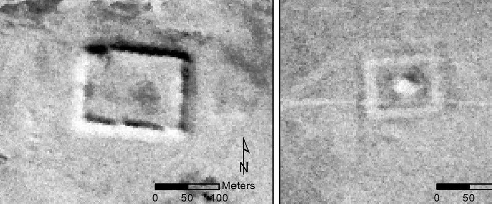
In their analysis, the researchers benefited from the fact that Roman camps were usually laid out according to a similar, rectangular pattern. In this way, they were able to filter out the 10,000 questionable structures discovered in the satellite images that apparently came from the Roman military. The new analysis also shows how quickly archaeologists have to hurry if they want to examine the structures on site. Of the 116 structures that Poidebard described in the 1930s, the team was only able to identify 38 with certainty in the images taken a few decades later. This suggests “that the archaeological sites have been destroyed to a significant extent, and it is unlikely that this process has slowed in recent decades.” At the same time, the team hopes to release further spy images with possibly finer resolution and more viewing angles of the earth’s surface. Analysis of such data holds “tremendous potential for future discoveries in the Middle East and beyond.”