After several days of Israeli bombing on the largest refugee camp in the Gaza Strip, satellite images, unveiled on Wednesday, November 1, reveal the “growing horror” pointed out by UN experts.
Potential “war crimes”, according to the UN High Commission for Human Rights. For several days, successive Israeli strikes have devastated the largest refugee camp in the Gaza Strip, in response to Hamas attacks on the soil of the Jewish state on October 7.
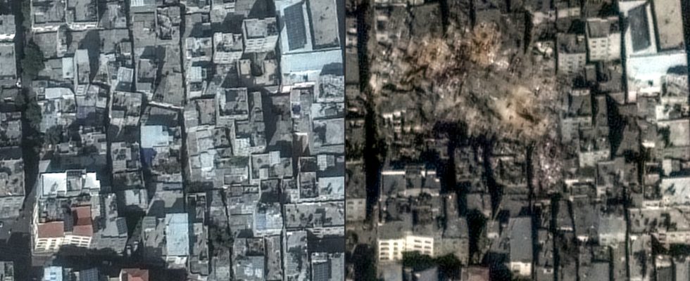
The Jabaliya camp, in the north of the Gaza Strip, shelters some 116,000 refugees and is gradually being transformed into a field of ruins. UN Secretary General Antonio Guterres said he was “appalled” by the situation while France was “deeply concerned”.
While Hamas reported “dozens” of deaths on Wednesday – a figure which could not immediately be confirmed – the Israeli army claimed to have eliminated the head of Hamas’ anti-tank unit, Muhammad. Atzar.
Visible damage
This Wednesday, satellite images from Maxar Technologies made it possible to assess, thanks to a comparison between October 31 and November 1, the extent of these airstrikes.
In these visualizations, significant material damage is visible, including a huge crater in the middle of the buildings.
The UN announced on Thursday that four of its schools in the Gaza Strip housing war-displaced people were hit by bombings on Thursday.
The UN agency for Palestinian refugees (UNRWA) said two of the affected schools were in the refugee camps of Jabaliya and Chati (north) and two others in Boureij, further south, and that the bombings reportedly left 23 dead.