Météo France kept nine departments in the East and South-East on orange vigilance for a heat wave on Tuesday, while 22 departments are on orange alert for thunderstorms from 3 p.m. The organization warns of a risk of “exceptional” thunderstorms with heavy rain, hail and strong gusts.
In detail, the nine departments on orange alert for heat wave are: Ain, Alpes-de-Haute-Provence, Alpes-Maritimes, Côte-d’Or, Isère, Jura, Loire, Rhône and Saône-et-Loire. Temperatures will rise again today to 39 degrees in Rhône-Alpes and 40 degrees in Provence-Alpes-Côte d’Azur.
THE 22 departments on orange alert to thunderstorms are: Ain, Allier, Aveyron, Cantal, Côte-d’Or, Doubs, Jura, Loire, Haute-Loire, Lozère, Haute-Marne, Meurthe-et -Moselle, Moselle, Puy-de-Dôme, Bas-Rhin, Haut-Rhin, Rhône, Haute-Savoie, Haute-Saône, Saône-et-Loire, Vosges and the Territory of Belfort .

–
Meteo France
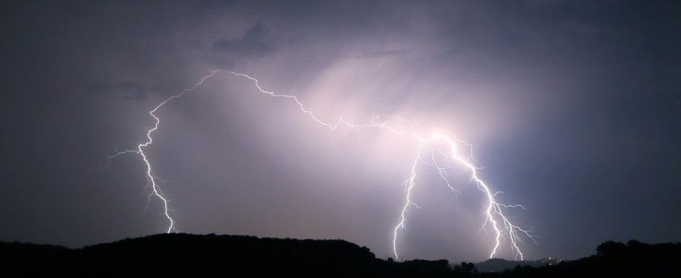
A risk of “exceptional”, “extreme” thunderstorms
From Auvergne to the North-East, “the storms could be exceptional”, warns Météo France. These potentially very violent storms will develop from Auvergne to Alsace, warn the organization. “These storms could start at midday and last until the end of the night, towards the north-eastern facade of France, going from Haute-Savoie to the German and Luxembourg border” explains Tristan Amm, forecaster at Météo France. This extreme episode could be accompanied by “very intense and brief rains, a very impressive rumble of thunder, hail which can damage homes, sometimes with hailstones of several centimeters, and strong gusts which can locally exceed 100-120 km / h under thunderstorms”, he details on franceinfo
.
The potentially violent phenomenon is “due to a very hot and humid air mass, which will become unstable over the hours and cause these storms, says Tristan Amm, there is extremely hot air in the low layer over France and elsewhere, and cold air at altitude which comes up against the northwest and allows the formation of all these storms.
The Keraunos meteorological observatory warns, for its part, of a risk of “extreme” thunderstorms.
Parks and gardens closed, TER traffic interrupted in several regions
The SNCF announces this Tuesday on Twitter the interruption of the circulation of the TER “on different axes” until 7 p.m. due to weather conditions. The axes concerned are from 2:30 p.m.: Lyon – Bourg-en-Bresse; Lyon – Paray-le-Monial; Saint-Etienne – Le Puy-en-Velay. From 2.30 p.m. to 7 p.m.: Lyon – Macon; Lyon – Ambérieu; Lyon – Saint-Etienne; Lyon–Roanne; Saint-Etienne–Roanne; Saint-Etienne-Montbrison “It is possible that traffic will resume after 7 p.m. but this remains to be confirmed”indicates the SNCF.
In Burgundy-Franche-Comté, TER traffic is interrupted on five lines
from 3 p.m. this Tuesday: Besançon – Saint-Amour; Besancon-Clerval; Dole-Vallorbe; Besancon – Morteau; Vesoul-Clermont. Some lines will also be stopped this Tuesday evening
in the two Alsatian departments.
Parks and gardens will close due to storms like in Nancy
or Strasbourg. The city and the Eurometropolis will prevent access to the following parks: Pourtalès, Orangerie, Contades, Citadelle, Schulmeister, and Albert Schweitzer and municipal cemeteries from 3 p.m.
In Dijon, the city has also decided to close its parks and gardens. Even if the first storms have already passed over the extreme north of the department, without causing any damage, other precipitation is expected for the end of the afternoon and the evening, recalls France Bleu Bourgogne.