Status: 02/20/2022 10:25 p.m
After the hurricane “Zeynep”, “Antonia” is the next severe storm to hit northern Germany. A storm surge warning is also in effect. Rail traffic in the north will continue to be massively obstructed – even on Monday.
The series of storms does not stop for the time being. During the course of Sunday, the wind from storm “Antonia” freshened up and could cause dangerous storms, especially on Monday night. “It gets interesting from 9 p.m. on Sunday evening,” said a meteorologist from the German Weather Service (DWD) in Offenbach. For a large part of the Baltic Sea coast in Mecklenburg-Western Pomerania, there is a storm warning of hurricane gusts with speeds between 105 and 120 km/h from midnight – provisionally until 8 a.m. in the morning. The situation in the north is not expected to relax significantly until Tuesday.
Further information
Storm surge warning for the North Sea coast early Monday morning
There is also for the German North Sea coast the risk of a storm surge. The responsible Federal Maritime and Hydrographic Agency (BSH) reports: “On Monday, the night high water and the morning high water on the East Frisian coast will be 1 to 1.5 meters higher than the average high water, on the North Frisian coast and in the Weser and Elbe area 1.5 to 2 meters higher than the mean flood and in the Hamburg Elbe area 2 to 2.5 meters higher than the mean flood.” The storm surge danger exists until around 7:20 a.m. on Monday.
Hanover – Hamburg railway line “extremely affected”
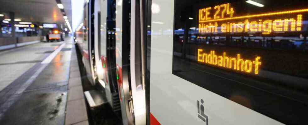
After the storm “Zeynep” caused severe damage in northern Germany, especially in the night to Saturday, the clean-up work continues. Due to storm damage, rail travelers must still expect train cancellations and delays. According to Deutsche Bahn, the railway line between Hanover and Hamburg is “extremely affected”. The storm knocked down rows of trees there and caused damage to the overhead lines for kilometers. Some of the catenary masts would have to be completely repositioned. In the Uelzen area, the overhead line construction had to be completely rebuilt over a length of 600 meters. Bahn employees are in constant use.
Long-distance trains are heading north again
Deutsche Bahn still advises against traveling to and from Hamburg. However, long-distance trains have been running again between Hamburg and Hanover since Sunday morning – via Bremen with a travel time extension of one hour. Long-distance trains from Stuttgart and Munich via Cologne – Dortmund to Bremen and Hamburg have been running hourly since midday.
On Sunday evening, Deutsche Bahn announced that there were no long-distance trains between Hamburg and Rostock/Stralsund. This also applies to the Berlin Rostock/Stralsund and Norddeich Mole/Emden and Cologne routes.
Deutsche Bahn recommends that travelers find out about the Internet service from Deutsche Bahn or contact the free special hotline on 08000 99 66 33. Passengers who would like to postpone their trip planned for the period from February 17 to 21, 2022 can either use their already booked long-distance ticket flexibly up to and including February 28 or cancel it free of charge.
Lower Saxony: No private operator trains after 9 p.m
The regional train services of the private operators metronom, enno and erixx in Lower Saxony will gradually be phased out until 9 p.m. on Sunday. The companies announced this on Sunday afternoon. After 9 p.m. there are no more trains, and an emergency bus service runs on all routes until Monday. According to current estimates, train traffic will probably not resume until Monday afternoon.
Schleswig-Holstein: Nordbahn and AKN run less
The Nordbahn shared theirs on Sunday afternoon home page with the fact that reconnaissance trips on the lines of the RB63 and RB82 will start on Monday from 6 a.m. due to the renewed storm warning. The first train journeys are cancelled, a line replacement service has been set up. There are also restrictions on the other lines – probably until Monday afternoon. Because of the announcement of the new storm, train traffic may have to be stopped altogether.
The AKN also shared on their home page with the fact that there could be severe restrictions due to the severe gusts of wind that have been announced.
Severe damage from storm “Zeynep”

The North Sea island of Wangerooge lost about 90 percent of its beach because of the storm.
On the night of Saturday, a number of people in northern Germany were injured by the hurricane “Zeynep”. In Lower Saxony, in the Wurster North Sea Coast municipality, there was even a fatal accident during the storm: a man fell ten meters from a collapsing roof while doing repair work. The North Sea island of Wangerooge lost about 90 percent of its beach because of the storm. There is hardly any sand left over a distance of one kilometer, said Wangerooges island mayor Marcel Fangohr. The sandy beach was also damaged on the North Sea island of Langeoog. “In parts there is no longer a beach at all, the edge goes all the way to the dunes,” said the island’s mayor, Heike Horn.
Hamburg: First very severe storm surge since 2013
On Saturday, for the first time since 2013, Hamburg experienced a very severe storm surge with more than 3.5 meters above the mean high tide: the water level at the St. Pauli gauge reached 3.75 meters above the mean high tide at around 5.30 a.m. That is why parts of the Speicherstadt and Hafencity were also flooded. In the areas flooded by the storm surge, individual vehicles had to be recovered. According to the fire brigade, cars were drifting in the Elbe water that had burst its banks in Hafencity. Emergency services were able to rescue two people from a vehicle with a rubber dinghy, and they were taken to a hospital with severe hypothermia.
Ferry traffic still with restrictions
Because of the storm situation, not all ferries in the north are running as usual. The Wyker Dampfschiffs-Reederei (WDR) announced that it was driving on the Föhr-Amrum line with an adjusted timetable – also on Monday. Passengers should check before boarding via the WDR website to inform. There are still cancellations on Monday on the Cuxhaven-Helgoland route and back. There is more information on the website of the shipping company Cassen Eils. The Elbe ferry from Glückstadt to Wischhafen announced on Sunday evening, due to the predicted storm and high water on Monday, to only start shipping at 10 a.m.
Because of the next storm “Antonia”, travelers between Rostock and Denmark must expect disabilities again on Monday. As the ferry company Scandlines announced on Sunday, the trips between the Hanseatic city of Rostock and the Danish port of Gedser have been canceled until Monday noon.
Further information


