5.7 terapixels
This interactive Mars map invites you to take a walk over our neighboring planet
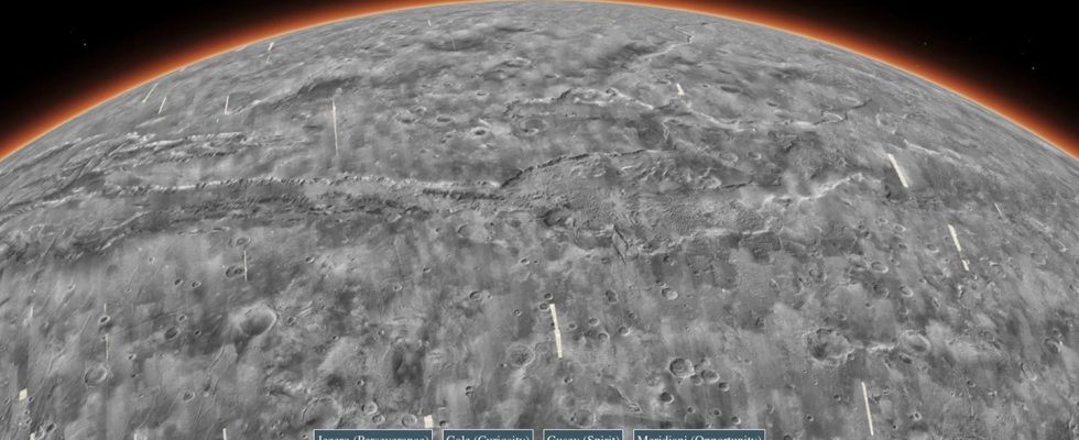
The “Global CTX Mosaic of Mars” invites you to take a virtual walk across Earth’s neighbors. Click here for the interactive version.
© JPL/Caltech/ESRI/Nasa
A new map of Mars offers the opportunity to explore the red planet in detail. Printed out, it would cover a stadium.
Mars may not be our closest neighbor in the solar system, but no other planet (besides our homeland, Earth) has been explored as thoroughly as the red planet. A number of probes and rovers have given us a pretty good picture of what our outer neighbor is like.
A new interactive map of Mars now offers everyone the opportunity to take a (at least) virtual walk across Mars. The Global CTX Mosaic of Mars released by NASA’s Jet Population Laboratory (JPL) is the most detailed map of the Martian landscape to date. “Cliffs, impact craters and dust swirl trails are captured in fascinating detail in a new red planet mosaic,” the JPL said. The map was composed of 110,000 black-and-white images taken by the Mars Reconnaissance Orbiter. The images cover around 25 square meters of surface per pixel. Production lasted six years.

The mosaic is the highest-resolution global image of Mars, writes the JPL. And further: A printout of the 5.7 terapixel image is large enough to cover the Rose Bowl Stadium in California. The interactive map is freely accessible and is intended to be used by science as well as the public (you can find the link above under the picture). As JPL scientist Laura Kerber says, “It’s both a beautiful artifact and useful for science.”
In the video: A new map of Mars also comes from Abu Dhabi
Just a few days ago, researchers from New York University Abu Dhabi and the Center for Space and Science in the United Arab Emirates provided completely new insights into the structure of the red planet. Using data from the United Arab Emirates’ Mars orbiter, they have created a map that shows geological features on Mars in a level of detail never seen before. Thanks to special camera technology, the Mars orbiter al-Amal not only provides images of the surface, but also of the lower layers of the Martian atmosphere. As the researchers from New York University Abu Dhabi explain in a statement, the new map shows the polar ice caps, mountains, volcanoes, remnants of ancient rivers, lakes, valleys and impact craters. More about this in the video:
