Seine-Maritime, the North, the Rhône delta and valley, the Paris basin and, to a lesser extent, the west of France. According to Citepa, the organization responsible for quantifying greenhouse gas emissions in France, it is in these regions that the highest emitting municipalities in France are located. This observation can be drawn thanks to a dataset that the organization published in December 2023. Represented in the map below, it lists the emissions of these gases responsible for global warming from each French municipality, by relating to their surface.
Industrial municipalities are logically the most emitting
In addition to pointing out these few territorial black spots, the Citepa data confirms in particular that the municipalities where the most greenhouse gases are emitted are those which have a strong industrial or energy tropism.
Thus, the two French municipalities with the highest emissions are Fos-sur-Mer (Bouches-du-Rhône) and Dunkirk (North), two towns where ArcelorMittal metallurgical sites are located. These two municipalities respectively emit 9 and 8.4 million tonnes of CO2 equivalent per year, the equivalent, for each of them, of the emissions of a country like Albania.
The rest of the classification reveals municipalities which host oil refineries, notably Gonfreville-L’Orcher (Seine-Maritime, 4th), Martigues (Bouches-du-Rhône, 5th) or Port-Jérôme-sur-Seine (Seine- Maritime, 6th). Le Havre (9th) also suffers from its powerful industrial fabric.
Note that, taken together, the ten most polluting municipalities in France alone account for 8% of French emissions and that many of them host factories appearing in the list of the 50 most polluting industrial sites, which the government intends to decarbonize. as a priority.
Read also : How much greenhouse gas is emitted in your municipality?
Large cities by definition very polluting
Large French cities, densely populated and hosting a large number of activities, are also very well represented in the top 10 most polluting cities in France.
Paris, with its 2.1 million inhabitants and its vast employment pool, is thus the 3e French municipality in terms of greenhouse gas emissions. Its 5.6 million tonnes of CO2 equivalent are nevertheless almost 40% lower than the emissions of Fos-sur-Mer. But they still correspond to the combined emissions from Liberia and Lesotho. A non-negligible total which explains why we have not reduced the emissions of cities to their number of inhabitants, which would have had the consequence of reducing the importance of the latter’s emissions compared to small municipalities hosting a factory. or significant breeding.
In fact, the cities of Marseille (7th), Toulouse (8th) and Lyon (10th) also appear in the top 10 French municipalities where the most greenhouse gases are emitted.
The West, as a symbol
This predominance of urban or highly industrial municipalities in the most polluting municipalities in France is confirmed if we focus on those which, in the West, quickly appear later in the ranking.
Thus, the largest city in the West, Nantes, and the Mayen commune of Saint-Pierre-la-Cour, which hosts a Lafarge group cement plant, appear at the gates of the top 10 (14th and 15th respectively). A little further away come the very industrial Saint-Jean-de-Folleville (Seine-Maritime, 30th) and Rennes (34th), the 2e city in the Great West.
But, notes Colas Robert, expert at Citepa, if these values confirm the national plan, they should not make us forget that these Regions have “a particular profile due to its demographic growth and an agricultural specialization focused on livestock”. This is in particular what explains why, even when they do not reach peaks, the quantities of greenhouse gases emitted in each municipality rarely drop to very low levels.
The pollution of the town says nothing about that of its inhabitants
Note that these figures do not say much, if anything, about the individual attitude of the inhabitants of the municipalities concerned.
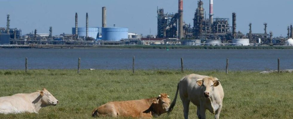
This data actually takes into account emissions at the precise location where they took place. For example: a resident of Nantes who goes in a thermal car to Angers to eat a piece of red meat in a restaurant (two highly emitting practices) would not see his emissions linked to his home in Nantes. Those linked to the steak he tasted would be linked to the place of breeding of the cow from which it was taken (since that is where it emitted methane), while those linked to its Nantes-Angers journey are distributed throughout the route he followed.
It emerges in particular from this method that the municipalities which see major roads pass have a higher total emissions than other municipalities of their ilk, which is particularly visible on the map from Citepa, which reminds us that transport contributes alone account for a third of French broadcasts. The same goes for municipalities where there are numerous cattle farms (as is the case in the West in particular, or even in part of Auvergne).
It is therefore impossible to say by looking at these data whether the inhabitants of a municipality emit more greenhouse gases than those of the neighboring municipality.
Read also : INTERVIEW. Greenhouse gases: a “link between population and emissions” but to be “qualified”
An even larger carbon footprint
Furthermore, Citepa data does not take into account greenhouse gas emissions linked to goods consumed in France but produced abroad. They therefore do not allow us to deduce the average carbon footprint of the inhabitants of a territory, not even that of the territory as a whole.