Deal of a lifetime
Auction coup: Man buys old nautical chart for $239,000 – it’s actually worth millions
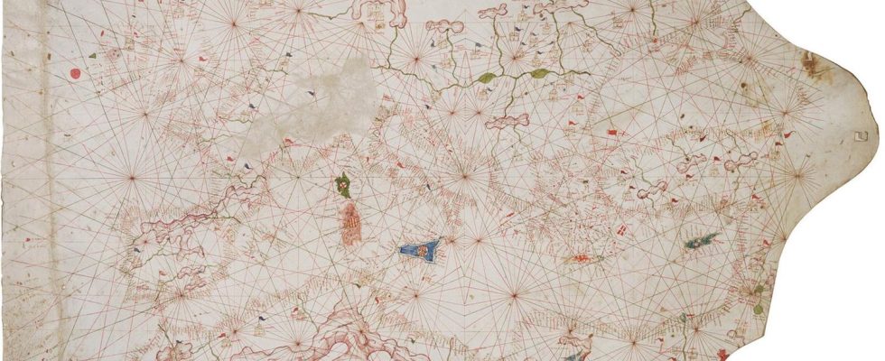
A portolan is a book with nautical information, including landmarks, lighthouses, harbor conditions and currents.
© Christie’s

A card dealer from San Diego may have made the deal of a lifetime last year. Because Christie’s auction house apparently dated a card completely wrong, he only paid a fraction of what it was actually worth.
When it comes to particularly rare and old valuables, it obviously helps if you have very detailed knowledge. This is shown by the case of Alex Clausen, a card dealer and expert from San Diego, USA. When the auction house Christie’s auctioned off parts of the collection of billionaire couple Ann and Gordon Getty last fall, an old nautical chart caught his eye. The auction house stated that it was a mapping of Europe dating from the years 1500 to 1525. The estimate was 100,000 to 150,000 US dollars in the room. Clausen and a business partner paid $239,400. Why?
Alex Clausen was sure that the Portolan map, which is particularly characterized by the visible network of lines, must be a much older example. The Los Angeles Times describes why he thought that. Accordingly, Granada in southeastern Spain was marked on the map with a different flag than the other Spanish kingdoms on the Iberian Peninsula.

A wrong card at Granada got the ball rolling
This means that the time period that Christie’s stated as the possible period in which the old nautical chart was created no longer fits – Granada was only a bastion of the Moorish kingdom until 1492, after the capitulation of the last Nasrid ruler Muhammad XII. it belonged to Spain. The map cannot therefore have been drawn this way after the end of the 15th century.
Clausen initially assumed that the map was probably created around 1420, it is said. After discussions with other experts, the number 1350 was even mentioned. Clausen needed to know more – and drove to New York, where the card had been issued before it was sold.
On the edge of the card you can see a kind of king – that’s what Clausen was after. Christie’s wrote that the figure was an image of King Solomon holding a compass in his hand. It turned out that it was Claudius Ptolemy, a cartographer from the second century. Appropriately, next to the figure it says in Latin: “In these mountains, King Ptolemy uses a world compass and constructs a mappa mundi (medieval world map) using astrology, longitude and latitude.” Another mistake from Christie’s.

Most recently, it was noticed that the borders on mainland Europe point to a time before the end of the Hundred Years’ War (1337 to 1453) – and there were still Crusader fortresses in the east. The auction house’s information could not be correct – Clausen and his partner struck.
Final date: 1360 – final price: $7.5 million
After purchasing the card for a price above the original estimate, he sent it to a laboratory in New York. Pigments should be analyzed there and carbon should be analyzed. The result: The map was created at the earliest in the 1320s to 1350s and at the latest in the 1390s to 1420s. Further research, including historical articles from the nineteenth century, the experts agreed on a year of creation: 1360. Jackpot.

Aside from the fun that Clausen and his partners had during the research, the card also turned out to be an absolute bargain. It is currently being offered through Barry Lawrence Ruderman’s antique trade as “the fourth oldest surviving ‘complete’ portolan map of Europe” under the nickname “Rex Tholomeus”. You have to ask the shop for the price; the “Los Angeles Times” talks about 7.5 million US dollars, which is now being asked for.
source: Los Angeles Times, Christie’s, Barry Lawrence Ruderman