The intermediate stations of certain TGV lines will not be served this Thursday
TER traffic will be interrupted on Thursday in four regions affected by the storm. Concerning TGVs, they will continue to carry out:
- Paris – Rennes and Paris – Lille, without serving intermediate stations located outside high-speed lines.
- Paris – Le Mans, from Thursday 2 p.m. if nothing prevents it. Services to Nantes and La Rochelle will not be provided
- Paris – Tours, Poitiers, Angoulême, Bordeaux and South Aquitaine, without restriction.
Actions to take to stay safe when the storm arrives
The arrival of the storm is accompanied by many risks, linked to the forecasts of strong wind gusts, flooding waves and heavy precipitation. Falling branches or even entire trees are likely, as are flooding.
BFMTV.com takes stock in this article on the precautions to take to stay safe in the coming days.
Storm Ciaran ticks the boxes of a ‘weather bomb’
Storm Ciaran was described as a probable “weather bomb” by François Gourand, forecaster at Météo-France.
“We use (this term, Editor’s note) when a depression strengthens rapidly, with a deepening of 24 hectopascals in less than 24 hours. The depression (Ciaran) seems to meet the criteria of a meteorological bomb”, he explained this Monday at a press conference.
This term highlights the speed at which a disturbance forms but not its “intensity” underlines the forecaster, as we detail in this article dedicated to the notion of “meteorological bomb”.
Waves of 8 to 10 meters towards Brittany on Thursday
“The Atlantic coast will be affected by very strong waves, of the order of 8 to 10 meters towards Brittany” this Thursday, indicated Météo-France, citing the risk of wave-submersion.
15% of France potentially affected by gusts over 100km/h
During the passage of storm Ciaran, around 15% of mainland French territory is likely to experience gales of more than 100 km/h, Météo-France indicated during a press conference this afternoon.
Possible red alert for strong winds for Thursday
Météo France raised the possibility that a red alert for violent winds would be triggered for Thursday, mainly for the first half of the day.
Without predicting which departments could actually be classified red, the agency specified this afternoon that Finistère, Côtes d’Armor and La Manche should be the most affected by the winds.
Finistère and Morbihan on orange rain-flood alert for Wednesday
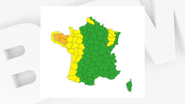
The departments of Finistère and Morbihan are placed on orange rain-flood vigilance for the day of Wednesday, in addition to the orange vigilance for violent winds which already concerned them, as well as the Côtes d’Armor, Météo France announces.
Storm Ciaran formed off the coast of Canada and is now set to cross the Atlantic
Storm Ciaran formed on the other side of the Atlantic, off the coast of Newfoundland, and will strengthen over the next 24 hours, said François Gourand, forecaster at Météo-France, during a press conference this afternoon.
He confirmed that the storm would be near France late Wednesday.
TER traffic also interrupted in Hauts-de-France
TER train traffic will also be interrupted in Hauts-de-France on Thursday, in addition to the Brittany, Centre-Val de Loire, Normandy and Pays de la Loire regions.
Gusts and flood waves expected in the west and north of France
Gusts of up to 170km/h are expected on the Breton and Normandy coasts from Wednesday evening. The passage of the storm should also cause gales that could exceed 130 km/h in Brittany. Gusts of more than 100 km/h are expected elsewhere in the North-West.
Submersion waves of up to 6 to 8 meters are expected on the Atlantic coast, while waves of around 6 meters are expected on the Channel coast.
TER traffic interrupted in 4 regions Thursday
Due to the passage of storm Ciaran, SNCF announces “a total interruption of traffic” on “all TER lines in the Brittany, Pays de Loire, Normandy and Center Val de Loire Regions, with the exception of the Paris line Bercy-Nevers which is circulating normally.
Three Breton departments placed on orange vigilance on Wednesday
As storm Ciaran approaches, Météo France has already placed three Breton departments on orange alert on Wednesday due to the expected violent winds. These are Finistère, Morbihan and Côtes-d’Armor.
This vigilance could change in the coming hours.

Storm Ciaran expected Wednesday evening, gusts up to 170 km/h
Hello and welcome to this live broadcast dedicated to the arrival of storm Ciaran, which will hit France via the Breton tip from Wednesday evening, before progressing over the rest of France until midday on Thursday.
Significant wind gusts are expected from Wednesday evening: up to 170 km/h on the North-West coast and up to 130 km/h inland.

