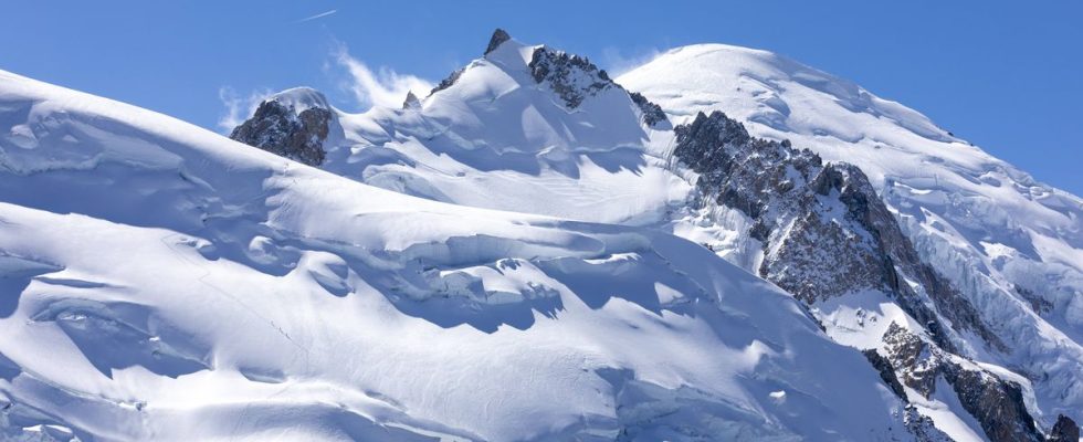
The figure of 4,807 meters is written in all geography books. However, the summit of Mont Blanc continues to evolve. As proof, in 2007, it reached almost 4,811 meters, compared to 4,807.81 precisely at the last score, in 2021.
Every two years, since 2001, the expert surveyors of Haute-Savoie have given themselves the mission of measuring “the roof of Europe”, the new altitude of which will be revealed this Thursday. How do we collect such precise data? How long does it take or how many people are needed? 20 minutes make the point.
Who was part of the expedition?
Twenty-two people, grouped into eight teams, left on September 14 to climb the summit of Mont-Blanc. Including seven guides. The team included five female surveyors “recruited from the four corners of France” but “sufficiently seasoned in the mountains”. The group was supervised by Liv Sansoz, world climbing champion, now a high mountain guide who put together a short three-day training session for them in order to climb in the best conditions. Finally, Olympic champion Martin Fourcade, ambassador of this new measure, was also there.
This “human and technical” challenge required three days of climbing, ten hours of final ascent for 2,500 meters of elevation gain, knowing that the group took with them ten kilos of equipment and a drone.
How is the summit of Mont Blanc measured?
The least we can say is that the technologies and methods used have evolved considerably. At the very beginning, experts used the “triangulation” method. “They stationed themselves on different peaks lower in the valleys and based themselves on the known altitude of Lake Geneva. With optical instruments, they then calculated the angles” between two reference points, relates Denis Borrel, expert surveyor and president of the Mont-Blanc measurement commission. This was without counting on a few errors. “At the time, we thought that Lake Geneva was located 800 meters from sea level when in reality it was 350 meters. There was already an error of 500 meters at the base,” he smiles.
“Then some went up with barometers that measured pressure and temperature. Then from the 1960s, there were more precise triangulations thanks in particular to lasers,” continues Denis Borrel. Today, expert surveyors rely on “a constellation of satellites” and “permanent GPS stations” located in the Chamonix valley which allow them to have a “centimeter position in real time” by carrying out point surveys. per point. But climbing to the top remains necessary.
The objective of the expedition is also to measure the “summit cap” in order to obtain a “cubature” (volume of ice and snow above 4,800 m) and to compare it to previous years. In their expedition, the surveyors embarked a drone to “model the ice cap in three dimensions” in record time. Ten minutes on the clock. They also used a mobile GPS, placed on the snowy summit above 30 meters of ice layer, in order to record “maximum data” for 1.5 to two hours. “This provides protection in case there is a wind of more than 50 km/h or fog. With this in mind, the drone could not achieve its goals,” specifies Denis Borrel.
What will this data be used for?
The new data will then be transmitted to glaciologists and meteorologists who will analyze them in order to “know whether or not there is an impact of global warming at that altitude”.
If the “retreat of the glaciers is proven”, the expert surveyor recalls that they are located at “3,000-3,500 meters”. Much lower than the summit. “In the past, the skullcap was a fridge. Usually, the temperature rarely reaches zero but this was the case once this year, where the mercury rose to 10°C over a period of two-three hours during the day. These measurements will allow you to know if it melts or shrinks on one side or the other. Or if it goes back up,” explains Denis Borrel.
Why do we measure the peak in September?
Measurements were taken at the end of spring but experts prefer to retain those recorded in mid-September. “You would think that in the spring the peak would be higher because of the snowfall. But this is not the case because the storms are much more severe in winter and therefore the summit is more planed, answers Denis Borrel. This is why measurements in September are preferable. »