Story
New Museum of Marble Map of Ancient Rome
The huge marble map (Forma Urbis Romae) of ancient Rome in the Archaeological Park of the Monte Celio Museum. photo
© Gregorio Borgia/AP/dpa
The original consisted of a total of 150 marble slabs and was 13 meters high and 18 meters wide: a huge marble map of Rome from the third century. Parts of it are now open to the public.
Italy’s capital has a new museum – dedicated to the remains of a huge marble map of ancient Rome that hasn’t been seen for many decades. In the Museum of Forma Urbis – the name of the map – near the Colosseum, fragments of a monumental and quite precise city plan from the third century, which was made under Emperor Septimius Severus (145-211), have been on display since Friday.
The huge original, made up of a total of 150 marble slabs, was 13 meters high and 18 meters wide. The scale of the reproduction was 1:240. In the Middle Ages the plan, which was part of a temple complex, was destroyed. Remains of it have been repeatedly discovered during excavations over the past few centuries – a total of almost 1,200 fragments, but ultimately only a little more than a tenth of the original map. It wasn’t until 2014 that archaeologists brought fragments back to light.
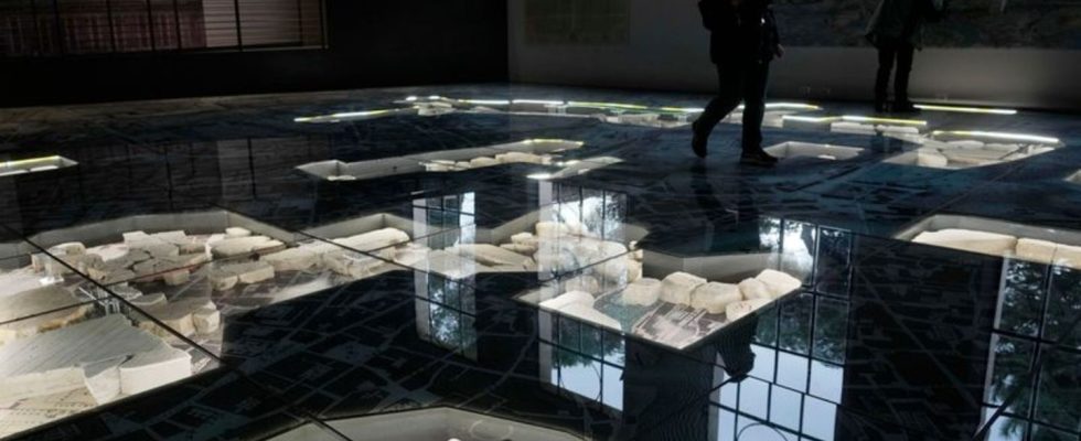
With the help of computer simulations, an attempt was made to place the recovered marble pieces as precisely as possible in their old position on a new plan. The basis for this is one Map of Rome made in 1748 by surveyor Giovanni Battista Nolli. The Italian is considered the author of the first precise city plan of the Eternal City. The map is housed in the floor of the new museum so you can walk over it.
The last time a large portion of the marble pieces was visible to the public was in 1939. In recent decades they have been stored in another museum. The new museum is part of an archaeological park on the Celio, one of the seven hills of Rome.