
Press
Germany continues to be hit by heavy rain. Due to the extreme weather, there is a risk of flooding, especially in the west. The news ticker.
Update from 1:18 p.m.: The weather situation remains tense in Germany. There are now several official danger reports for Saarland. Accordingly, there is a risk of flooding as a result of the extreme rainfall. It is assumed that the water levels at the gauges in the Saar catchment area will rise very sharply, the State Office for Environmental and Occupational Safety in Saarbrücken announced in a flood situation report on Friday (May 17th).
While the water levels on the Blies, Nied and Prims are expected to partially fall again on Saturday night, according to the forecast, the peak on the Saar is expected during Saturday morning. Until then, developed land, buildings and cellars could flood in some places, the state office said. The German Weather Service (DWD) has announced heavy, continuous rain until Saturday night, especially in the areas west of the Rhine. After that the rain should slowly subside.
Weather in Germany: Flood warning for the Hornbach and the Schwarzbach catchment area
Update from May 17th: 10:45 a.m.: The extreme rainfall continues to have a firm grip on western Germany. Rivers in the federal states of Baden-Württemberg, Rhineland-Palatinate, North Rhine-Westphalia and Saarland are affected by flood warnings due to persistent rainfall. As the cross-state flood portal (LHP) reports, there is even a warning of major flooding for the Hornbach and the Schwarzbach catchment area in Rhineland-Palatinate.
The Felsalbe, a tributary of the Hornbach in the West Palatinate, has already reached a level of more than 290 centimeters, which corresponds to a 20-year flood. “Rapidly rising, unusually high water levels are to be expected. Flooding of built-up areas and traffic disruptions are also possible,” informs the LHP. According to the portal, in some cases even increases up to the level of once-in-a-century floods are possible.
Extreme storms in Germany – purple warning level for the west of the country
Update from May 17th, 5:30 a.m.: On Thursday evening (May 16th) and on Friday night (May 17th) there were severe storms in large parts of Germany. In Nuremberg the fire department had to rescue two people from their car in a flooded underpass. According to the German Weather Service (DWD), the highest weather warning level applied, especially for parts of Bavaria and Baden-Württemberg. According to Kachelmannwetter, up to 60 millimeters of rain fell locally in the Swabian Alb.
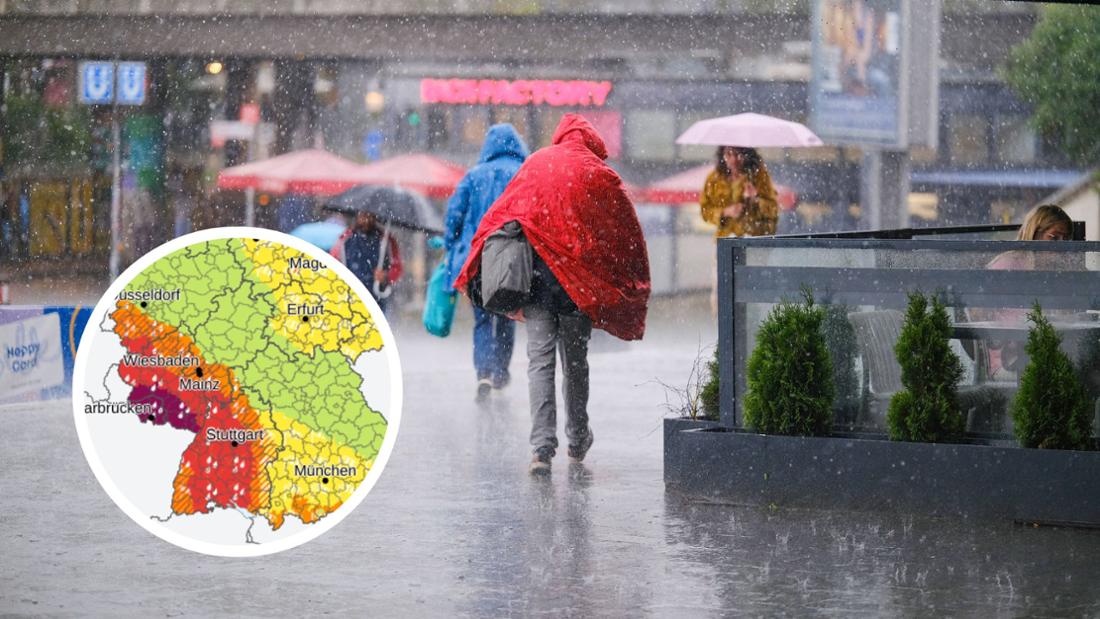
The highest warning level purple (level 4) from the DWD remains current in the morning. According to the DWD, heavy and sometimes extremely heavy rainfall is expected, particularly in the extreme southwest, Saarland and Rhineland-Palatinate, but also in large parts of Baden-Württemberg and southern Hesse. Thunderstorms and strong to stormy gusts are still possible in the south and east.
Storms in Germany: Red alert in the southwest – “Be very careful”
Update from May 16th, 5:15 p.m.: The warning area has now expanded. The orange to red alert now applies in dozens of regions in Germany. These include the following federal states:
- Baden-Württemberg
- Rhineland-Palatinate
- Saarland
- Bavaria – especially in the north, southwest and in the Munich area
- North Rhine-Westphalia – especially in the west
- Hesse – especially in the south
- Thuringia – below Erfurt
“If you have to expose yourself to the weather, be very careful,” advises the DWD. Meteorologist Karsten Brandt from donnerwetter.de said Picture-Newspaper: “The storm started on Thursday and lasted for a very long time. Filled cellars and slipping slopes are possible. A very difficult situation.” The weather situation is expected to remain tense until the weekend.
Red alert for several regions – extreme weather is rushing towards Germany today
Update from May 16th, 12:23 p.m.: The weather map turns red in parts of Germany. According to the DWD, the red alert applies particularly in Saarland, Rhineland-Palatinate and Baden-Württemberg and is therefore a level 3 severe weather warning. This is advance information about “heavy, heavy, continuous rain” that is expected to occur from 6 p.m. coming from the southwest. There is an acute risk of flooding. Also A huge thunderstorm complex is approaching Bavaria.
In the east and north of the country there is an official warning of gusts of wind on Thursday. In coastal regions and in the low mountain ranges, strong gusts of wind with speeds between 70 and 85 km/h are possible.
Update from May 16, 10:20 a.m.: Baden-Württemberg was again hit by a thunderstorm with heavy rain on Thursday night. But things remained largely quiet, the police headquarters in the southwest said in the morning, according to the dpa with. “Despite the severe weather warning,” the situation remained “relaxed,” said a spokesman for the Ludwigsburg police.
However, according to the DWD, new thunderstorms will appear during the day – with a high potential for severe, heavy rain and stormy gusts. The maximum temperature values therefore range from 14 to 21 degrees. According to the information, persistent, severe rain is expected in some areas on Friday night.
It’s expected to stay rainy on Friday: The DWD is forecasting heavy, long-lasting rain in the southwest. The precipitation is expected to move northward during the day. The temperatures are between 12 and 18 degrees at most. The weather is expected to calm down at night. In the north it remains cloudy and rainy, in the rest of the country it continues to clear up, according to the DWD.
Weather alarm in Germany: Model maps show heavy rain – “you have to be very careful”
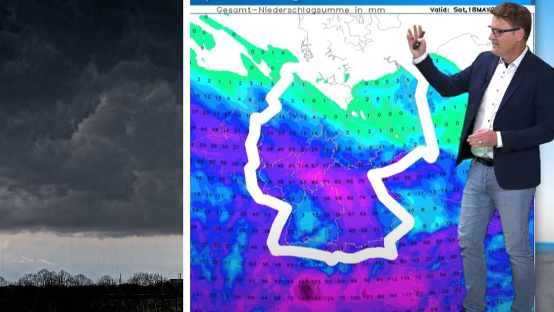
First report from May 15th: Frankfurt – Full cellars, flooded streets. Germany is threatened with serious storms, warns meteorologist Dominik Jung von Weather.net. The Weather-Expert warns: Flood alarm is in effect until Whit Saturday. Dangerous heavy rain is particularly heading towards the southwest.
The model maps show up to 100 liters of rain per square meter, and in some places it can even be more. “That means full basements, flooded streets. You really have to be very careful until Saturday. “It’s getting bad here,” says Jung. Danger applies in:
- North Rhine-Westphalia
- Hesse
- Rhineland-Palatinate
- Saarland
- Baden-Württemberg
- Bavaria (partly)
And the weather models agree Danger of floods agreed, heavy rain is coming to Germany. All maps glow pink around the Eifel, the French forecast even puts the precipitation warning well into the middle of the country – with extensions as far as Brandenburg.
“Where the storms occur, it can be violent”: Flash floods are threatening in Germany
“It won’t affect everyone, but where the storms are, it can be severe,” says Jung. The flash floods only occur locally and usually only last two to three hours, but in some cases there is a danger to life, according to the weather expert. The storm situation has the south of Germany in trouble. Hoch Uwe only ensures sunny days in the east and north, but it stays here Fall in the weather at Pentecost out of.
The German Weather Service (DWD) also warns of local storms. On Wednesday (May 15th) thunderstorms will appear from the edge of the Alps and the foothills from the early afternoon, move northwestwards and coalesce in the evening. That means: BavariaBaden-Württemberg, Rhineland-Palatinate, southern Hesse and the southwest of North Rhine-Westphalia are affected.
Weather expert feared severe storm damage: “The water comes and goes, dirt and damage remains”
The DWD does not rule out local heavy rain of up to 60 liters per square meter. And the situation will not change at least until Friday (May 17th). In some cases there is a threat of storms and heavy, continuous rain. The dangerous situation therefore also applies until at least Saturday (May 18th).
The storm should be over by the weekend. Jung states: “The water comes and goes, dirt and damage remains.” The meteorologist fears severe storm damage, but calms things down a bit and makes it clear: it shouldn’t be as bad as it was back then in the Ahr Valley. (moe)