Actually, there is not much that is special about measuring point number 16,000. Like thousands of its sisters, which are scattered all over Germany in forests, meadows and fields, it shows how high – or low – the groundwater level is at this point. This measuring point is located in the Ebersberger Forest, where there are two other stations. But there is one thing that makes 16,000 special: It is the groundwater measuring point in the district, where the sharpest decline in groundwater was measured in the last 32 years: minus 1.01 percent per year.
This emerges from data that the SZ together with the research network Corrective local evaluated. The groundwater measurements of the last 32 years were collected at a total of eight measuring points in the Ebersberg district – and thousands more almost throughout Germany – in order to determine any long-term trends. The result: 16,000 is not alone, there is a tendency to decline in all places, but it is strong in two places.
The measuring points are all located in the north of the district
Looking at the Map, on which the measuring points are entered, you can see that they are only in the northern part of the district. For this reason and because groundwater reservoirs do not adhere to district borders, it is only possible to make limited statements about “the groundwater level” in the entire district. However, the data for other measuring points on the Munich gravel plain, the largest aquifer in southern Germany, above which Ebersberg is also located, look similar. At least that’s what Klaus Moritz from the Rosenheim Water Management Office can report. And this data does not bode well.
Between the years 1990 and 2021, the groundwater level at the measuring point in the district with the lowest decline fell by 0.60 percent per year. At measuring point number 16 014, the sister of 16 000, which is also in the Ebersberg Forest, the decline is one percent per year. At the other measuring points, the level fell between 0.74 and 0.88 percent per year. One percent decrease corresponds to a drop in the groundwater level of 0.04 meters per year. That doesn’t sound like much at first – extrapolated to 32 years, however, this corresponds to a decrease of 1.28 meters.
According to the data collected, the groundwater level has fluctuated over the past 32 years. The highest level at measuring point 16,000 was 519.8 meters above sea level and was measured in 2004. Soon after, however, things went downhill rapidly, and the next year – ie 2005 – the lowest level for this period was recorded at 515.8 meters above sea level. Groundwater levels recovered somewhat over the next decade, but have been falling rapidly since the mid-2010s. Currently is noisy Bavarian State Office for the Environment the groundwater level, at 515.75 meters above sea level, is even below the low of 2005.
Ebersberg is one of the 127 districts – from the twelve federal states for which data from around 5500 measuring points are available – in which there are sharply falling measuring levels, i.e. a decrease of less than one percent per year. 49 percent of the evaluated measuring points also reached their low between 2018 and 2021.
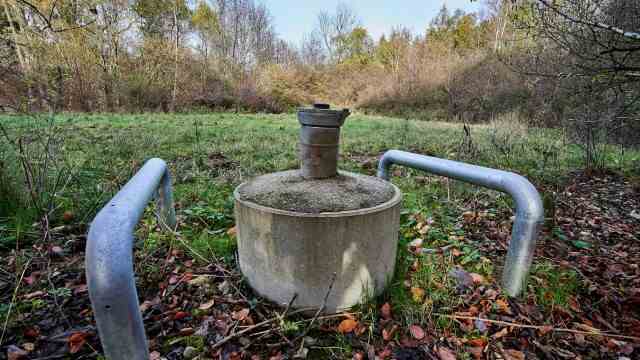
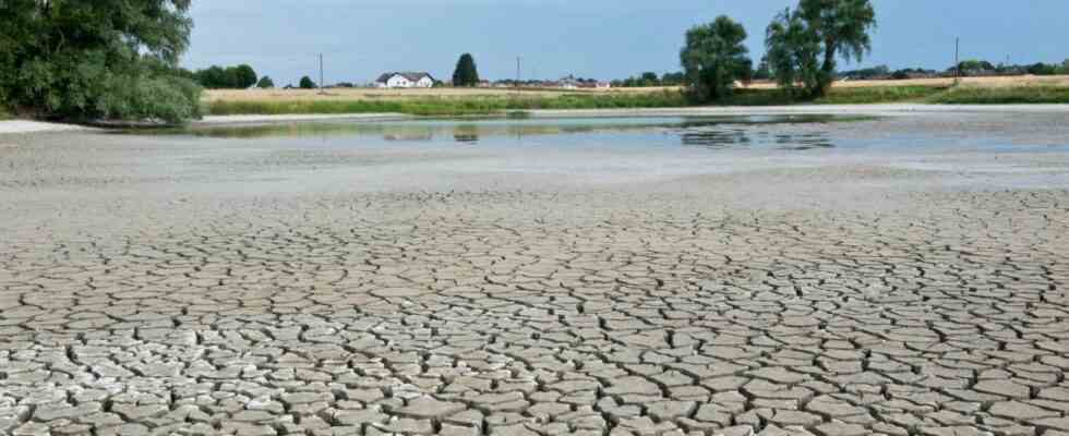
The groundwater measuring point 16,000 at Heilig-Kreuz-Geäume in the Ebersberg Forest seems inconspicuous. But over the past 32 years, it has seen the highest average drop in groundwater in the county.
(Photo: Peter Hinz-Rosin)
Thilo Kopmann, CEO of the water supply and disposal service provider Vemo München Ost, operates several wells in the district and is also aware of the low water levels. “2022 was a very dry year,” says Kopmann. He says that wet years would come again. However, it is questionable to what extent these can counteract the long-term trend.
So why are the levels falling? From a purely mathematical point of view, the extraction is simply more than what seeps back into the ground. Large industries and agriculture, thermal power plants and private households – the thirst for water is great everywhere.
One of the main reasons for falling groundwater levels is climate change
However, consumption is not the biggest problem. “The Munich gravel plain is not overexploited,” says Klaus Moritz. The reason for the sinking is trivial: the past few years have been very dry due to global warming, less precipitation and higher evaporation ensure less groundwater formation. “Since 2003, the years have always been medium-humid at most, mostly rather dry.” In addition, Moritz continues, other factors influencing the groundwater, such as sealing and the diversion of water from arable land, are also fading.
In addition, instead of continuous rainfall, heavy rain events occur more frequently, even in winter, as Thilo Kopmann explains. During this time of the year, the groundwater reservoirs refilled. “If we get another dry winter, we have a problem.” If the amount of precipitation is high but accumulated for a short period of time, less groundwater forms. “80 percent then flows off as surface water,” Kopmann continues.
The biggest adjustment screw is climate protection
Due to the global dimension of the groundwater problem, there are only a few ways to prevent the levels from falling. Restricting water consumption, both privately and economically, can provide relief. Otherwise, the biggest adjustment screw is climate protection when it comes to preserving groundwater.
“Groundwater has a long memory. We would now need several years with above-average levels of moisture for the levels to recover,” emphasizes Klaus Moritz. However, most climate models assume that current trends will continue.
So do we need deeper wells? “It’s very controversial,” says Thilo Kopmann. The wells of the Vemo are currently at a depth of 40 to 50 meters. “Of course you could also go down to 200 to 250 meters,” says Kopmann. But that has been forbidden so far, and quite rightly so: “These groundwater reserves are the services of general interest for future generations. We have to think twice about tapping into them.” However, Kopmann cannot rule out that this step will be necessary in the future. According to Klaus Moritz, there is still no acute shortage of water for the local water supply.
The water cent could lead to lower withdrawals of water
Another political measure is currently also being discussed in Bavaria. Unlike in most federal states, there is no so-called water withdrawal fee in Bavaria: fees that are incurred by the respective federal state when groundwater is withdrawn. In addition to Bavaria, only Hesse and Thuringia do not have such a regulation.
In the federal states in which there is such a fee, this is between 1.5 cents per cubic meter in Saxony to 31 cents per cubic meter in Berlin. Bavaria’s Prime Minister Markus Söder (CSU) had in his Government statement 2021 also announced that they would introduce a water cent for Bavaria to provide an incentive for lower water consumption. So far, however, nothing has come of it.
If the protection of the groundwater does not take place or takes place too late, measuring point number 16,000 will experience dry times. It was set up in 1938, when the level was 518.18 meters above sea level. A historical one depression recorded 16,000 in December 1973 with a reading of 514.97 meters above sea level. That is 0.78 meters from today’s water level. If the trend of the past three decades continues unchecked, this low will be undershot in twenty years.
This research is part of a cooperation between the Süddeutsche Zeitung and Corrective local, a network for local journalism that implements data-driven and investigative research together with local editors. Correctiv Lokal is part of the non-profit research center Correctiv, which is funded by donations. More info at correctiv.org.