Speed limit display
Finally: One of the best functions of Google Maps is now coming to Germany
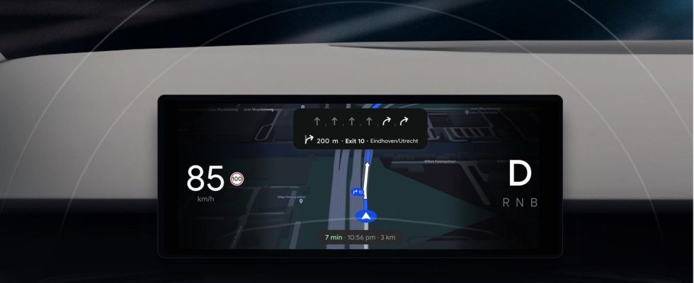
Google Maps – here in the car view – now also shows the top speed
© Google / PR

The navigation solution Google Maps is getting lots of new functions. One of the most important ones has been around for a long time in other countries: Maps now finally shows the speed limit.
You have just entered the highway. And now you’re wondering: How fast can I drive here exactly? If there are no signs, you can only orientate yourself to the other road users. In other countries, Google also helps: in Spain, for example, the Maps app has been showing the top speed for years. Now the feature is coming too Germany.
Late at the speed limit
Google announced this in a recent blog post. Accordingly, the feature is slowly being rolled out for the iPhone and Android apps and will reach all users in a few weeks. Companies don’t have to: If you use a current version of the app, the function will turn on by itself at some point.

Teaser image: Getty Images / tobyfraley
Germany is quite late with the speed limit in Google Maps. Google had already introduced it in other countries in 2019. Although the data was also confirmed for Germany, it was never introduced here. This meant that Apple’s map app was even able to overtake Google: the speed had been displayed in Apple’s navigation solution since last spring (you can find out more here).
Immersive driving
The focus of the post was actually a different function: With the so-called Immersive View, Google wants to make the routes even clearer. If you select it, the app switches to a new view in which the route is essentially placed in a 3D view of the real world. In the view generated from street view and satellite images, you can then see exactly where the path leads. And familiarize yourself with the locations in advance.
But you probably shouldn’t drive in this view. To make orientation better while driving, Google has announced an even more detailed map that will be released soon. Individual lanes of a motorway are then clearly visible; the route marked in blue then leads over the correct lanes in the standard view.
Information for electric cars and more
Other functions include expanded information for drivers of electric cars. Google Maps not only lists charging stations, but can also show, if desired, whether they are compatible with your own car. A display showing when the charging station was last used should help sort out defective charging stations.
AI functions from Google Lens are integrated directly into the app and are intended to help you orientate yourself more quickly in unfamiliar places. Information such as nearby restaurants or ATMs is displayed directly in the camera image.
Source:Google