News Weather
From Wednesday to Thursday, an active disturbance circulates over a large northern half bringing a lot of rain, but also an episode of snow and freezing rain from Normandy and the Paris Basin to the north-eastern borders, with many disturbances to be expected in the transports.
Between Wednesday and Thursday, France is at the heart of a conflict between air of subtropical origin which rises from the Bay of Biscay and colder air which descends from Northern Europe. Temperatures are particularly contrasting between the north and the south on Wednesday afternoon with temperatures close to 0°C in Nord-Pas-de-Calais while we will approach the 20°C mark in the south of Aquitaine .
Here is the chronology of the announced winter deterioration:
During the night from Tuesday to Wednesday, a disturbance from the Bay of Biscay gradually invades the west and north of the country. It is accompanied by mild air at altitude which overcomes much colder air near the ground, which causes an episode of freezing rain which begins in the evening in Normandy then reaches Ile-de-France during the night. France, Picardy and the Grand Est region. Extreme caution is recommended if you have to travel at night, particularly on icy secondary roads.
Wednesday morning, the disturbance will move up to the Nord-Pas-de-Calais region where the layer of cold air will be thicker. It will generally be snow, but it is not excluded to temporarily have a little Freezing Rain, particularly in the southern part of the region. Further south, a mild spell will occur and the rain will replace the freezing rain in Normandy and Ile-de-France in the Grand Est. In Picardy, the Somme could be slow to see the thermometer rise and still experience freezing rain for a good part of the morning. The mild weather will be more effective in the Oise and Aisne with mainly rain.
Wednesday afternoon, it will snow north of an approximate line going from Abbeville to Cambrai. As the afternoon progresses, the cold air will gain ground towards the south, so that by the end of the afternoon, the snow will affect the regions north of a line going from Le Havre to Saint-Quentin and Vervins.
Wednesday evening, the situation will become complicated with snow which will continue to progress towards the south and intensify between Upper Normandy, Picardy and the Ardennes. It will easily hold to the ground giving 2-3 centimeters per hour. The snow will weaken in Nord-Pas-de-Calais and will eventually evacuate to the south. On the other hand, the snow will gain ground towards Lower Normandy, Ile-de-France and the north of Champagne where the soils will begin to whiten at the end of the evening.
During the night from Wednesday to Thursday, it will snow from Normandy to the Grand Est via Picardy and Ile-de-France. Snowfall will be moderate with average intensities of 1 to 2 cm per hour and locally up to 3 cm per hour from the Ardennes to the north of Lorraine.
Thursday morning, the disruption will evacuate Normandy, Ile-de-France and Picardy, but with snow-covered roads, traffic conditions will be complicated on secondary road networks and untreated axes. The disruption will remain quite active in the Grand Est region as far as Burgundy with traffic conditions which could be delicate on secondary networks.
Thursday afternoon, the disturbance will slide towards the south and give snow in the plains, from Berry to the north of Auvergne-Rhône-Alpes up to Limousin. The quantities will be less than in the northern regions and the snow will mainly hold on the lower heights.
The entire Auvergne-Rhône-Alpes region will experience an episode of snow at low altitude in the evening before the disturbance clears out during the night from Thursday to Friday.
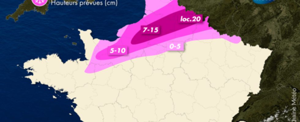
What snow depths should we expect?
Wednesday, it is between Upper Normandy and northern Picardy that we expect the highest snowfall levels. The snow will fall steadily between the end of the afternoon and the evening with more than 10 cm on the ground and locally 15 to 20 cm on the most exposed heights or plateaus. Note that with the northeast wind which will blow in the evening, some formations of snowdrifts are not excluded on the small country roads.
THURSDAY, it is in the Grand Est region that the snow depths will be the highest, particularly between the Ardennes and the north of Lorraine with 10 to 15 cm of snow on the ground. In the rest of the region, snow depths will generally be between 5 and 10 cm. In Ile-de-France, snow depths will often be between 5 and 8 cm (3 to 5 cm in Paris under the effect of the urban heat island).
Over the entire snow episode, Upper Normandy, Picardy and the north of the Grand Est region will be the snowiest. This episode comes after a winter of 2022-2023 where snow was notable for its absence or rarity in these regions.