
The intense tropical cyclone Batsirai will be closest to our coasts this Thursday, February 3, around 6 or 7 am. Reunion is still on red hurricane alert, since 7 p.m. yesterday. Follow our live here.
•
Cyclone Batsirai is closest to Reunion this Thursday, February 3 around 6 or 7 a.m., about 180km away. At 4 a.m., he was 210 km from our shores. The intense tropical cyclone slowed to 9 km/h. On red hurricane alert since 7 p.m. last night, Reunion is confined. The population must not go out and must keep informed of the evolution of the situation.
Follow our live on the situation here:
6:50 a.m. Degraded weather in the heights of Saint-Louis.
If the center of Saint Louis is generally preserved from bad weather this Thursday morning, this is not really the case in the heights of the town. “It’s been a flood since yesterdayconfides to us a resident of uproar (St. Louis River). We are in it!” Meteo France confirms that the rains concern in particular the heights of the South and the interior of the island where the accumulations are the most marked (611 mm in 24 hours in No Bellecombe and 403mm to Great Elbow).
6:40 a.m. The situation remains under control in Saint-Joseph.
What is the weather like in the Sud Sauvage commune? In Saint-Joseph, there is a lot of wind and rain but there is no major damage to report.“, indicates Emeline K/Bidipermanently elected to Saint Joseph. The Langevin river and that of Battlements remain on yellow alert for risk of flooding. In addition, a total of 19 people are currently accommodated in the various accommodation centers in the municipality.
Most homes are without water. Saint Joseph is indeed one of the municipalities where preventive cuts were decided after the placement of The meeting on red alert. Power cuts are also to be deplored in certain sectors.
6:25 a.m. Batsirai will stay near our shores for several hours
According to Weather France Reunionthe cyclone Batsirai will stay several hours off The meeting.
“The time of closest passage is not fundamental, because the system is moving slowly and will be 180 or 200 km from our coasts for several hours.Explain Philippe Caroffchief forecaster at Weather France Reunion. He does not stand still, but moves very slowly. It will still get very slightly closer to the north of the island and the weather conditions will remain degraded“.
“It will be closest in the morning, but we are affected by the periphery of the system so it does not change anythingcontinues Philippe Caroff. In terms of rains, the biggest is to come, because they will arrive with the rear part of the phenomenon which will be very active. In other sectors, the weather will deteriorate in areas of the Port and possession at the end of the day. The northeastern half of the island will be affected by the rains to come at the end of the afternoon“.
Batsirai’s position at 6:30 a.m. this Thursday.
•
6:20 a.m. A family of ten poisoned with carbon monoxide
Firefighters have carried out around twenty interventions since Reunion was on red alert. A night which was therefore relatively calm on the side of Sdis 974. No reckless behavior to deplore last night. The Reunionese respect the instructions given to them to remain confined. A family of ten people nevertheless had to be taken care of by the emergency services for carbon monoxide poisoning, following the use of a generator.
6:10 a.m. Batsirai’s trajectory
At 4 o’clock in the morning, Batsirai was located 200 km from the coast of Reunion. It continues to approach and still moves at a speed of 9km/h.
“It will be closest around 6 or 7 a.m.indicates Ludovic Carreforecaster at Meteo France. It should pass as close as possible, about 180 km from our coasts. It might weaken, but will still be very intense“.
Look at the predicted trajectory:
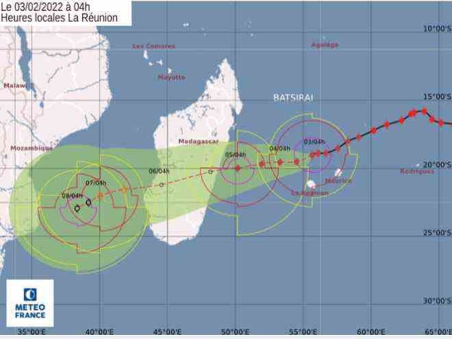
Batsirai’s forecast trajectory at 4 o’clock.
•
5:45 a.m. SOS, panel adrift, in Saint-Denis.
Still on South Boulevard, at St Denis. Not sure that this traffic sign always points in the right direction…
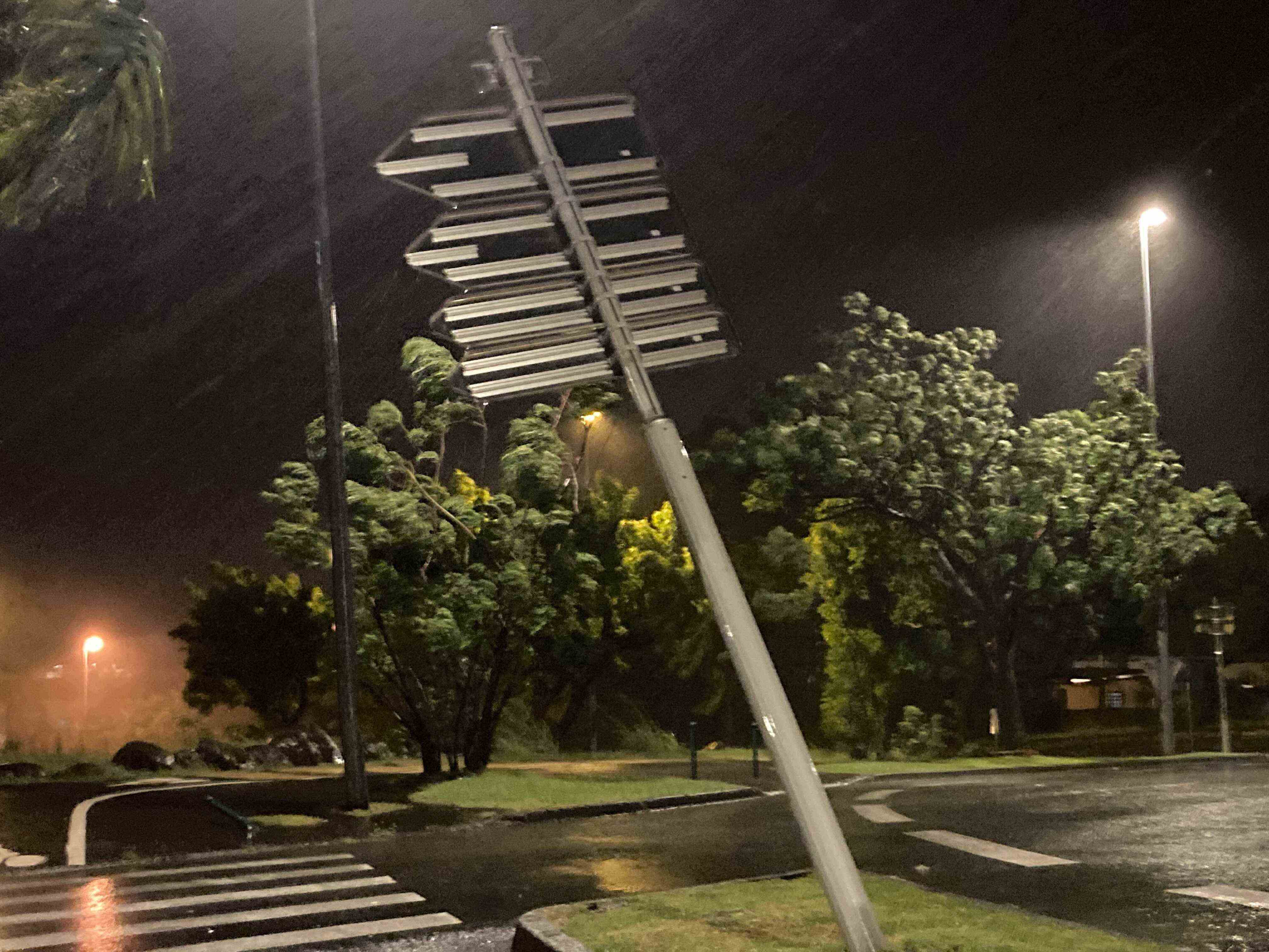
South Boulevard of Saint Denis
•
5:40 a.m. Météo France announces gusts greater than 110 km / h on the coast and 150 km / h in the heights
AT St Denison the South bourlevard, near flowery fieldthis tree also suffered the repeated assaults of the wind during this night from Wednesday to Thursday.
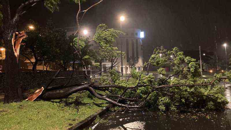
South Boulevard of Saint Denis
•
5:35. The ravages of the wind on the southern boulevard, in Saint-Denis.
This billboard visible on the south blvdat St Denis, did not resist strong gusts of wind. As a reminder, The meeting is still on red alert. Reunionese must therefore remain confined to their homes.
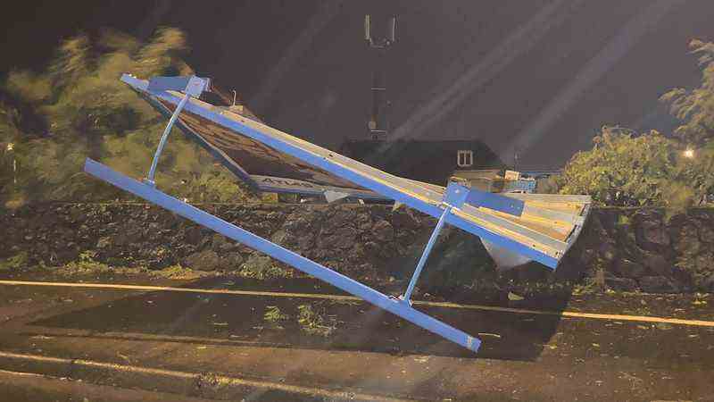
South Boulevard of Saint Denis
•
5:20 a.m. Find the lists of accommodation centers and emergency numbers
The municipalities on the island have opened emergency accommodation centers for people whose accommodation does not provide a sufficient level of security.
Click here to find in our article the list of accommodation centers and emergency numbers.
Watch the report below St. Benedict :
Batsiraï: Saint-Benoit opens its living and accommodation center
5:05 a.m. “It’s quiet in Saint-Paul”
“We didn’t have much rain, no wind, the night was calmexplains Emmanuel Séraphin, mayor of Saint-Paul. Currently, nine people are in the accommodation and living centers“. Yesterday, the town hall had taken the lead in installing an artificial dike.
5:00 a.m. Discover the front pages of the newspapers devoted to the passage of Batsirai this Thursday, February 3, 2022.
No newspapers distributed this Thursday, red alert obliges. But it is possible to consult them online. “Batsirai shakes Reunion“, title the Day-to-day which looks back on the damage and losses already deplored by farmers. “The prefect has not ruled out maintaining the red alert until Friday“, is it further clarified. “The prefecture on the front line, the town halls mobilized, a life-size test for the NRL“, enumerates on his side The Island Diary in its special edition Batsirai. It is true that the passage of the intense tropical cyclone will make it possible to judge the solidity of the work of art still under construction, in extreme conditions.
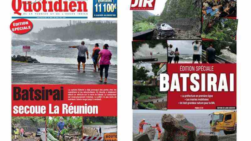
Headlines from Reunion Thursday, February 3, 2022
•
4h50. Roads closed, Reunion confined
Do not leave your home for the duration of the red alert. Several axes are closed: the coastal road, the RN5 Route de Cilaos, part of the RD48 Route de Salazie, the RD5 in Saint-Paul and finally the Ouaki raft between Saint-Louis and Saint-Pierre. These roads are only accessible for rescue.
4:40. Live on Réunion La 1ère radio, TV, internet
All night long, Réunion La 1ère accompanies you on radio, TV and on the internet. You can reach us on 02 62 99 2000.
4:30. Batsirai 200 km at 4 hours
Located 200 km from the Reunion coast this morning at 4 a.m., Batsirai continues to approach. According to Ludovic Carré, forecaster at Météo France, “the system always moves at a speed of 9km/h”. “It will be closest around 6 or 7 in the morning, he indicates. It should pass as close as possible, about 180 km from our coasts. It might weaken, but will still be very intense.”
Wind gusts of up to 110 km/h are expected in the next few hours. Even 120 km/h in Cilaos, 150 km/h on the highest peaks. If the western region is protected for the moment, gusts of wind will appear during the day
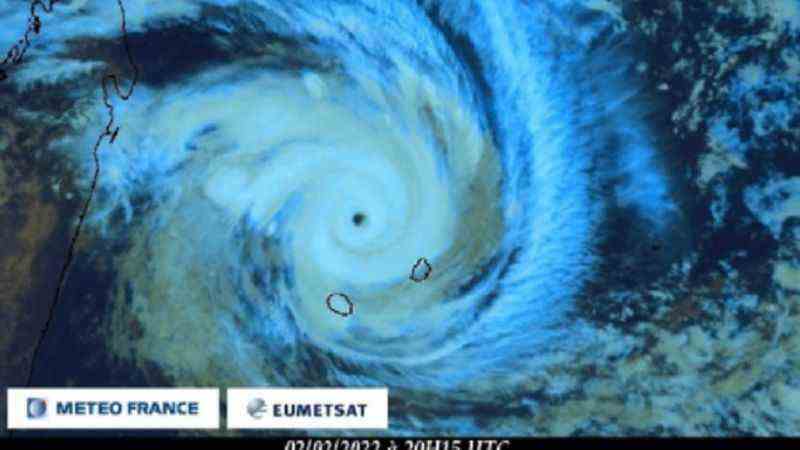
Batsirai at 4 a.m.
•
4:04. Reunion is on red alert
Do not go out under any circumstances, Reunion is confined during the red alert. Write down the emergency telephone numbers: the town hall of your municipality; 15 in the event of a medical problem (or 112 in the event of difficulty) and 18 for other requests for help. Traffic is prohibited, except for emergency services and services working on crisis management. The public information unit (CIP) is open to the single crisis number: 09 70 80 90 40.
4:03. Send us your photos and videos
From home and with caution, you can send us our photos and videos on WhatsApp number: 06 93 66 93 72.
4:02. Already power cuts
Power cuts are already taking place in the South, notably in Le Tampon, Saint-Joseph and Petite-Ile. The other municipalities affected are: Les Avirons, Saint-Leu, Etang-Salé, Sainte-Suzanne, Saint-André, Saint-Benoit and Saint-Denis. The deteriorating weather conditions during the day impacted 28,000 customers. Thanks to the mobilization of EDF teams and partner companies, 18,000 customers have been resupplied and 10,000 are being repaired.
To report an emergency situation presenting a risk to the person, contact the breakdown service: 0800 333 974
4h. Monitoring of water cuts
In several municipalities on the island, the distribution companies decided to cut off the water at the time of the passage on red alert, at 7 p.m. on Wednesday. The water is cut off at St Leu, at Avirons, at Entre Deux, at Le Tampon, at St Philippe and on part of St Joseph. It should also be interrupted tonight at Etang Salé. Preventive cuts have also been put in place in the east at Ste Rose and Plaine des Palmistes.
The aim is to prevent the pumping installations from being damaged during the passage of the cyclone (essentially the electrical and electronic part of the infrastructures) in order to be able to restart distribution as soon as the red alert is lifted. The idea is that it is better to deprive subscribers of water for a few hours than for several days if the installations have to be repaired.
Find our previous live from 00h to 5h by clicking here.
Find our previous live from 5 p.m. to 12 a.m. by clicking here.