
Seeing the crooked road is one thing, standing on the crooked road is another. The state road 2071 has a slope of 13 degrees at its most dangerous point between Schäftlarn and Straßlach-Dingharting – that is twice as much as the maximum permitted. The difference in height from one side of the road to the other is more than half a meter. Even when standing you have the feeling of slipping away. If the road were icy and slippery, cars would probably just slide down into the forest. That is why the road has been closed for a long time. And they will keep the Weilheim State Building Authority busy for a while.
Martin Herda and his employees received many calls with complaints this summer, “over a hundred”, he estimates. The friendly, sporty man in his late 30s and his department of the Weilheim road construction department can’t help it. Climate change with its heavy weather events is to blame for the landslide in 2071. The heavy rain this year caused damage not only on the way from Schäftlarn to Straßlach-Dingharting, but also in the entire Bad Tölz-Wolfratshausen district.
There were two mudslides at Walchensee, where brown waterfalls pushed waves of debris into the streets in front of them. The Rissbach swept a lot of slopes with it and came dangerously close to a road, in other places rocks fell on roads. The state building authority in Weilheim hired geologists around a year and a half ago and founded the “Geo-Risks Department”. “This is to be expanded further over the next few years,” says Herda.
However, there seems to be little patience among the people who would like to use the state road again in 2027. Some have simply pushed aside the no-through-traffic signs in the past few months and driven on the street anyway. According to the police, this can be a criminal offense if other road users are at risk. Martin Herda also shows the construction site in the hope of awakening understanding for the road closure.
The route is usually traveled around 3000 times a day. “That is relatively average, not too much, not too little,” says Herda. In April, however, the road had to be closed on one side, and in July after the heavy rain events even completely. Since then, many motorists have had to accept a 20-minute detour via Grünwald. That causes annoyance.
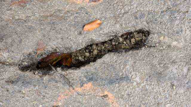
After the heavy rain, the asphalt shows several cracks that look like wounds.
(Photo: Harry Wolfsbauer)
The construction site is above the Gasthaus zum Bruckenfischer, behind the Isar Canal, after the first left turn. Twigs and leaves lie on the asphalt, the street cleaning apparently hasn’t been there for a long time. Excavators drive around on a section of road that is around 50 meters long. The asphalt has cracks in some places that look like wounds. In a slight curve the road leans strangely to one side. The reason for the inclined roadway is the special rock at this point: under a solid layer of Nagelfluh there is an erosion-prone mixture of clay, sand and the somewhat coarser silt. As the precipitation has increased in recent years, this layer has started to move and slowly dragged the road surface with it.
The movements are not new. The road construction authority has been taking measurements for 20 years, and the asphalt on the route has been renewed again and again. In 1979 there was even a sudden slide in the road. Herda shows photos of it: The road suddenly simply sagged into the depths. Half of the lane slid down a meter and a half. It looks like a stone waterfall.
So that something like this does not happen again in view of the heavy rainfall, the road construction authority has now started construction work. Despite the flora and fauna habitat, the authority has received a permit for this. “There is imminent danger,” explains Herda.
The aim of the construction work is to “drain” the Isar slope below the road. Construction workers dug eleven shafts along the lower side of the road, each five meters deep, and filled them with around ten centimeters wide boulders. In the future, the water should run off through these “Schroppenstützplatten”. In addition, they should support the road on its lower side.
On the upper side, on the slope side, the construction workers have dug a trench for drainage. The state road is to be extended by about one meter at this point. The road should therefore be more likely to be loaded on the slope side. Behind it, another layer of gravel is to be created, in which the water will seep and be diverted along the road. The drainage should lead the water a few meters along the road and then through under it, to one of the stretcher support discs on the opposite side. In addition, the road has to be straightened: along the slope side, asphalt has to be removed, in some places a layer of 30 centimeters.
Herda expects this work to be completed by the end of October. Then the road can be opened on one side and driven on again with the help of a traffic light control. However, it could take a while before the construction work is fully completed.
The Schroppen support discs were installed in August. The road construction authority has since intensified its measurements to test the effect of the measure. It turned out: the sliding movement was decelerated. But not stopped. Herda and his team will set up further measuring stations in November, also in depth, and commission an engineering office to find a long-term solution. This should then be implemented next spring. After the construction work in spring, the road should be accessible from both sides again.
It is unlikely that the state road will then remain free forever. The 2027 is at risk of erosion over a distance of 600 meters above the Isar Canal. “Overall, the slope is to be seen as a sliding body,” says Herda. He and his team will work on a solution.