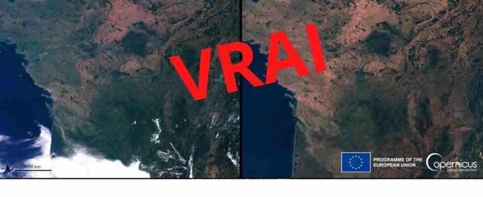
For the past few days, satellite images showing France have been circulating on social networks. These are two photographs side by side, in a “before/after” format with France in July 2021, green as a whole and that of 2022 with a decimated nature, in more orange colors.
The majority of Internet users who shared them specify that these images come from Copernicus, the European Union’s Earth observation program which brings together the Member States, the European Space Agency (ESA), the European Organization for exploitation of meteorological satellites (EUMETSAT), the European Center for Medium-Range Weather Forecasts (ECMWF), EU agencies and Mercator Ocean. The uncut images also display the name of the organization with the European logo at the bottom right.
These images caused a lot of reaction on social networks. If many deplore the dilapidation of the hexagonal greenery, others appear more skeptical. On the one hand, there are those who doubt the veracity of these images in view of the radical change observed in just one year. On the other, those who see it as proof that the year 2022 is only an exceptionally dry year and that the green visible in 2021 shows that global warming is not as strong as we can say. 20 minutes make the point.
FAKE OFF
These images are very real. Contacted by 20 minutesCopernicus confirms that these photographs come from the program, which also displays them on his websitealso responding to doubts about the date of the pictures.
We presented these images to Météo-France to understand such a difference between the two years. “We cannot draw any conclusions from images taken at a time T, only a year apart, explains a spokesperson, they should be compared with those of all previous years over the same period. »
The year 2022 is breaking drought records, the country having experienced (and is still experiencing) an unprecedented wave of fires, and rainfall was very poor in July over almost all of France. On average, over the country, the accumulation of aggregate precipitation amounts to 9.7 mm, ie a deficit of about 84%. July 2022 is the driest month of July over the period 1959-2022 on a national scale and the second driest month, all months combined, behind March 1961. This explains the orange color of the July 2022 photograph: nature burns.
These extreme conditions are however in line with the trend observed in recent years. Confirming global warming. Experts are also announcing that this summer will probably not be hotter than those to come.
It’s actually the month of July 2021 which has been an exception in recent years. The country has experienced an average excess of precipitation of more than 20%, an excess observed over a large part of the territory according to Météo-France: “From the Belgian border to Brittany and to the north of New Aquitaine as well as from the Grand-Est to north of Auvergne-Rhône-Alpes, the rain accumulations often exceeded one and a half times the normal. »
The summer of 2021 was recorded as the coldest and wettest summer since 2014 due to a “cold drop” that had stationed over part of Europe causing deadly flooding in Germany and Belgium. Paul Marquis, independent meteorologist, interviewed in our columns in September 2021 had also qualified last summer as a “pause in global warming”. Proponents of the “exceptional year” theory were therefore on the right track, but they read the cards backwards.