European Center for Medium-Range Weather Forecasts (ECMWF)
The sun will make its big comeback in France on Monday, with peak temperatures expected on Wednesday August 9.
WEATHER – A rise in temperatures “ vertiginous “. After a rather cool fortnight for the season in the northern half of France, a heat peak is expected this Wednesday, August 9, with mercury peaking between 30 and 36 degrees in the south of France, forecasts Météo France. But the high temperatures should not last, because as of Thursday, thunderstorms could break out.
On the southern half, “The sun will shine without counting from morning to evening”continues the forecaster, in its Tuesday bulletin. With one exception: low clouds will darken the sky on the coast of Provence-Alpes-Côte d’Azur, especially on the creeks. For the north, the weather will be more gloomy but will clear up in the afternoon, with peaks of 29 degrees expected.

Cold, hot, cold again, but what is the weather playing for this summer? Is it normal for temperatures to rise above seasonal norms so quickly after several days well below? Are we living a summer ” atypical ” ? Patrick Galois, forecasting engineer at Météo France, answered questions from HuffPost.
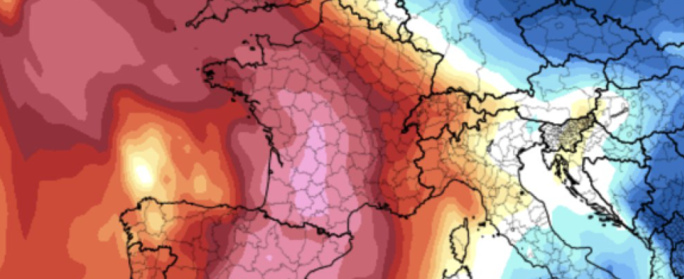
What meteorological phenomenon explains the arrival of heat In France ?
It is an effect of “pendulum” of air masses. We will go from a very cool air mass to a completely reversed situation in the middle of next week. The Azores anticyclone will rise towards France, and lead to a mass of warm air of subtropical origin, which will be particularly impressive in the south-west of France, where temperatures may rise by 15 to 20 degrees. compared to this weekend.
The peak of heat will be reached in the southwest this Wednesday, with temperatures exceeding 35 ° C, and even approaching 40 °C at the foot of the Pyrenees, next to the Basque Country or Béarn.
From Wednesday, this mass of hot air will rise over the whole of France while attenuating, and the 30 ° C could be crossed in certain departments further north. It will be warmer in the east on Thursday, and in the south-east on Friday, while temperatures will drop in the north of the Loire.
A further rise in temperatures is also expected for the long weekend of August 15, with summer heat sometimes exceeding 35°C.
After a gloomy weather marked by the depressions “Patricia” and “Antoni” this week, the heat arrived in France in a few days. Is such a sudden change in weather frequent?
We are indeed going to go from one extreme to the other: after a peak of freshness from Friday to Sunday, with temperatures 10 degrees below seasonal norms in the northeast, we will have temperatures 8 degrees above normal.
France is located in temperate latitudes, at the crossroads between the cold air masses of polar origin, and the warm ones that come from tropical regions. It is therefore normal to have a succession of cold and then hot episodes. This is typical of the variability of temperate climates like France.
The summer of 2023 seems very mixed. We experienced very hot weather in the Mediterranean in July, then cool temperatures in the northwest at the start of August. Are we living an atypical summer?
No, the summer of 2023 is not atypical, because there is no such thing as a typical summer. In 2022, we had a succession of heat wave episodes, with a summer that ended on the second step of the hottest summers after 2003. But let’s remember that in 2021, it was quite the opposite: a very wet, flooding in July and August. Summers can be very changeable from year to year.
What would you say to a Frenchman who doubts climate change after these few cool days in France?
Already, it’s not really freshness over time. In France, the month of July was warmer than normal, by around 0.8 degrees (compared to the period 1850-1900, editor’s note). The strong heat took refuge around the Mediterranean, so much so that some cities experienced their hottest month on record, such as Hyères, in the Var, or Calvi, in Haute-Corse.
Then, we must not confuse weather and climate. The weather has always been changeable, and it makes sense that, at times, temperatures are below normal. It is necessary to observe the climate on a larger spatial and temporal scale. For example, we experienced the hottest month ever observed on the planet, with intense heat waves on the American continent, in eastern Asia… And in the Mediterranean, temperatures approached 50 degrees. .
Right now, while the southern hemisphere is in the winter season, countries like Argentina are breaking heat records in the middle of winter. The few cool days in part of Europe do not call into question climate change.
See also on The HuffPost :